Pierson Township, Michigan

Last updated

Pierson Township, Michigan
USA Michigan location map.svg
Red pog.svg
Pierson Township
Usa edcp location map.svg
Red pog.svg
Pierson Township
Coordinates: 43°19′42″N85°30′30″W / 43.32833°N 85.50833°W / 43.32833; -85.50833
Country United States
State Michigan
County Montcalm
Area
[1]
  Total36.2 sq mi (94 km2)
  Land34.6 sq mi (90 km2)
  Water1.6 sq mi (4 km2)
Elevation
965 ft (294 m)
Population
 (2020) [2]
  Total3,363
  Density97.1/sq mi (37.5/km2)
Time zone UTC-5 (Eastern (EST))
  Summer (DST) UTC-4 (EDT)
ZIP codes
49339 (Pierson)
49329 (Howard City)
49343 (Sand Lake)
Area code 616
FIPS code 26-117-64040 [3]
GNIS feature ID1626900 [4]
Website www.piersontwp.org

Pierson Township is a civil township of Montcalm County in the U.S. state of Michigan. The population was 3,363 at the 2020 census. [2] The village of Pierson is located within the township.

Contents

History

The historical tribes inhabiting the region were the Ottawa, Chippewa and Potawatomi. Settlers began arriving in the 1830s.

Geography

The township is in far western Montcalm County, bordered to the west by Newaygo County and to the south by Kent County. The village of Pierson is in the southern part of the township. U.S. Route 131 crosses the township, leading north 27 miles (43 km) to Big Rapids and southwest the same distance to Grand Rapids.

According to the U.S. Census Bureau, the township has a total area of 36.2 square miles (94 km2), of which 34.6 square miles (90 km2) are land and 1.6 square miles (4.1 km2), or 4.37%, are water. [1] Several natural lakes, including Whitefish Lake and Little Whitefish Lake, are in the western part of the township.

Demographics

Historical population
CensusPop.Note
1870 755
1880 1,572108.2%
1890 1,410−10.3%
1900 1,250−11.3%
1910 1,129−9.7%
1920 929−17.7%
1930 802−13.7%
1940 8050.4%
1950 8576.5%
1960 96412.5%
1970 1,26130.8%
1980 1,70134.9%
1990 2,17728.0%
2000 2,86631.6%
2010 3,21612.2%
2020 3,3634.6%
U.S. Decennial Census [5]

As of the census [3] of 2000, there were 2,866 people, 1,015 households, and 795 families residing in the township. The population density was 82.6 inhabitants per square mile (31.9/km2). There were 1,343 housing units at an average density of 38.7 per square mile (14.9/km2). The racial makeup of the township was 96.27% White, 0.07% African American, 0.87% Native American, 0.28% Asian, 0.10% Pacific Islander, 0.59% from other races, and 1.81% from two or more races. Hispanic or Latino of any race were 1.36% of the population.

There were 1,015 households, out of which 40.8% had children under the age of 18 living with them, 68.1% were married couples living together, 5.9% had a female householder with no husband present, and 21.6% were non-families. 16.9% of all households were made up of individuals, and 5.7% had someone living alone who was 65 years of age or older. The average household size was 2.82 and the average family size was 3.18.

In the township the population was spread out, with 30.4% under the age of 18, 6.9% from 18 to 24, 30.5% from 25 to 44, 23.4% from 45 to 64, and 8.8% who were 65 years of age or older. The median age was 35 years. For every 100 females, there were 103.1 males. For every 100 females age 18 and over, there were 102.8 males.

The median income for a household in the township was $48,519, and the median income for a family was $50,573. Males had a median income of $36,921 versus $27,344 for females. The per capita income for the township was $19,216. About 3.4% of families and 5.0% of the population were below the poverty line, including 3.4% of those under age 18 and 5.7% of those age 65 or over.

Education

Tri County Area Schools serves the township. Tri County High School and Tri County Middle School are in the township. [6] [7] [8]

Related Research Articles

<span class="mw-page-title-main">Montcalm County, Michigan</span> County in Michigan, United States

Montcalm County is a county in the U.S. state of Michigan. As of the 2020 Census, the population was 66,614. The county is geographically located in the West Michigan region of the Lower Peninsula. The county seat is Stanton, and the largest city is Greenville. The county is named for General Marquis Louis-Joseph de Montcalm, military commander of French troops during the French and Indian War. The county was set off in 1831 and organized in 1850.

<span class="mw-page-title-main">Leroy Township, Ingham County, Michigan</span> Civil township in Michigan, United States

Leroy Township is a civil township of Ingham County in the U.S. state of Michigan. The population was 3,530 at the 2010 census.

<span class="mw-page-title-main">Rolland Township, Michigan</span> Civil township in Michigan, United States

Rolland Township is a civil township of Isabella County in the U.S. state of Michigan. The population was 1,210 at the 2000 census.

<span class="mw-page-title-main">Oakfield Township, Michigan</span> Civil township in Michigan, United States

Oakfield Township is a civil township of Kent County in the U.S. state of Michigan. The population was 5,782 at the 2010 census.

<span class="mw-page-title-main">Spencer Township, Michigan</span> Civil township in Michigan, United States

Spencer Township is a civil township of Kent County in the U.S. state of Michigan. The population was 3,960 at the 2010 census.

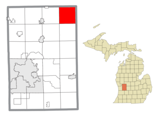
Bloomer Township is a civil township of Montcalm County in the U.S. state of Michigan. As of the 2020 census, the township population was 6,352, up from 3,904 in 2010.

Bushnell Township is a civil township of Montcalm County in the U.S. state of Michigan. As of the 2020 census, the township population was 1,516.

<span class="mw-page-title-main">Carson City, Michigan</span> City in Michigan, United States

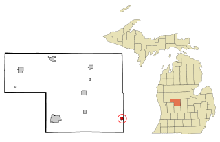
Carson City is a city in Montcalm County of the U.S. state of Michigan. The population was 1,120 at the 2020 census.

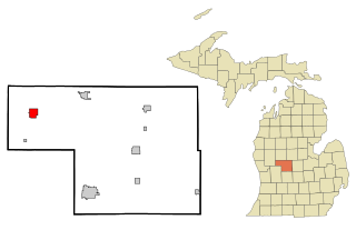
Douglass Township is a civil township of Montcalm County in the U.S. state of Michigan. The population was 2,239 at the 2020 census.

Eureka Township is a charter township of Montcalm County in the U.S. state of Michigan. The population was 4,211 at the 2020 census, up from 3,959 in 2010.

Fairplain Township is a civil township of Montcalm County in the U.S. state of Michigan. The population was 1,802 at the 2020 census.

Ferris Township is a civil township of Montcalm County in the U.S. state of Michigan. The population was 1,331 at the 2020 census.

<span class="mw-page-title-main">Howard City, Michigan</span> Village in Michigan, United States

Howard City is a village in Montcalm County in the U.S. state of Michigan. The population was 1,835 at the 2020 census. The village is within Reynolds Township.

Montcalm Township is a civil township of Montcalm County in the U.S. state of Michigan. The population was 3,394 at the 2020 census, up from 3,350 in 2010.

<span class="mw-page-title-main">Pierson, Michigan</span> Village in Michigan, United States

Pierson is a village in Montcalm County of the U.S. state of Michigan. The population was 229 at the 2020 census, up from 172 in 2010. The village is within Pierson Township.

Reynolds Township is a civil township of Montcalm County in the U.S. state of Michigan. The population was 4,279 at the 2000 census.

Crystal Township is a civil township of Montcalm County in the U.S. state of Michigan. As of the 2020 census, the township population was 2,619.

Evergreen Township is a civil township of Montcalm County in the U.S. state of Michigan. The population was 2,941 at the 2020 census.

Home Township is a civil township of Montcalm County in the U.S. state of Michigan. As of the 2020 census, the township population was 2,716.

Richland Township is a civil township of Montcalm County in the U.S. state of Michigan. The population was 2,868 at the 2000 census.

References

  1. 1 2 "2023 U.S. Gazetteer Files: Michigan". United States Census Bureau. Retrieved November 28, 2023.
  2. 1 2 "P1. Race – Pierson township, Michigan: 2020 DEC Redistricting Data (PL 94-171)". U.S. Census Bureau. Retrieved November 28, 2023.
  3. 1 2 "U.S. Census website". United States Census Bureau . Retrieved January 31, 2008.
  4. U.S. Geological Survey Geographic Names Information System: Pierson Township, Michigan
  5. "Decennial Census Official Publications". U.S. Census Bureau. Retrieved November 28, 2023.
  6. "2010 CENSUS - CENSUS BLOCK MAP: Pierson township, MI." U.S. Census Bureau. Retrieved on October 20, 2017.
  7. Home. Tri County High School. Retrieved on October 20, 2017. "Tri County High School 21338 Kendaville Rd. Howard City, MI 49329"
  8. Home. Tri County Middle School. Retrieved on October 20, 2017. "Tri County Middle School 21350 Kendaville Rd. [...] Howard City, MI 49329"