Montcalm County is a county in the U.S. state of Michigan. As of the 2020 Census, the population was 66,614. The county is geographically located in the West Michigan region of the Lower Peninsula. The county seat is Stanton, and the largest city is Greenville. The county is named for General Marquis Louis-Joseph de Montcalm, military commander of French troops during the French and Indian War. The county was set off in 1831 and organized in 1850.

Isabella County is a county located in the U.S. state of Michigan. As of the 2020 Census, the population was 64,394. Its county seat is Mount Pleasant. The area was known as Ojibiway Besse, meaning "the place of the Ojibwa". Isabella County contains the Isabella Indian Reservation, on which members of the Saginaw Chippewa Tribal Nation live.

Ionia County is a county located in the U.S. state of Michigan. As of the 2020 census, the population was 66,804. The county seat is Ionia. The Ionia County Courthouse was designed by Claire Allen, a prominent southern Michigan architect.
Arcada Township is a civil township of Gratiot County in the U.S. state of Michigan. As of the 2020 census, the township population was 1,671.
Hamilton Township is a civil township of Gratiot County in the U.S. state of Michigan. As of the 2020 census, the township population was 427.
New Haven Township is a civil township of Gratiot County in the U.S. state of Michigan. The population was 1,064 at the 2020 census.
Washington Township is a civil township of Gratiot County in the U.S. state of Michigan. The population was 813 at the 2020 census.
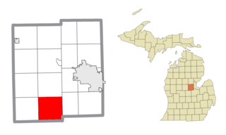
Porter Township is a civil township of Midland County in the U.S. state of Michigan. The population was 1,270 at the 2020 census.
Bloomer Township is a civil township of Montcalm County in the U.S. state of Michigan. As of the 2020 census, the township population was 6,352, up from 3,904 in 2010.
Bushnell Township is a civil township of Montcalm County in the U.S. state of Michigan. As of the 2020 census, the township population was 1,516.
Douglass Township is a civil township of Montcalm County in the U.S. state of Michigan. The population was 2,239 at the 2020 census.
Eureka Township is a charter township of Montcalm County in the U.S. state of Michigan. The population was 4,211 at the 2020 census, up from 3,959 in 2010.
Fairplain Township is a civil township of Montcalm County in the U.S. state of Michigan. The population was 1,802 at the 2020 census.
Ferris Township is a civil township of Montcalm County in the U.S. state of Michigan. The population was 1,331 at the 2020 census.
Montcalm Township is a civil township of Montcalm County in the U.S. state of Michigan. The population was 3,394 at the 2020 census, up from 3,350 in 2010.
Pine Township is a civil township of Montcalm County in the U.S. state of Michigan. The population was 1,870 according to the 2020 census.
Sidney Township is a civil township of Montcalm County in the U.S. state of Michigan. The population was 2,538 at the 2020 census.

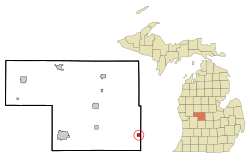
Stanton is a city in the U.S. state of Michigan. The population was 1,348 at the 2020 census. It is the county seat of Montcalm County.
Crystal Township is a civil township of Montcalm County in the U.S. state of Michigan. As of the 2020 census, the township population was 2,619.
Richland Township is a civil township of Montcalm County in the U.S. state of Michigan. The population was 2,646 at the 2020 census, down from 2,778 in 2010.