Big Rapids, Michigan | |
---|---|
Coordinates: 43°41′56″N85°28′52″W / 43.69889°N 85.48111°W | |
Country | United States |
State | Michigan |
County | Mecosta |
Area | |
• Total | 4.56 sq mi (11.82 km2) |
• Land | 4.45 sq mi (11.51 km2) |
• Water | 0.12 sq mi (0.30 km2) |
Elevation | 925 ft (282 m) |
Population | |
• Total | 7,727 |
• Density | 1,738.36/sq mi (671.13/km2) |
Time zone | UTC-5 (Eastern (EST)) |
• Summer (DST) | UTC-4 (EDT) |
ZIP code | 49307 |
Area code | 231 |
FIPS code | 26-08300 [3] |
GNIS feature ID | 1619197 [4] |
Website | cityofbr |
Big Rapids is a city and the county seat of Mecosta County, Michigan. The population was 7,727 at the 2020 census, [2] down from 10,601 in 2010. [5] The city is located within Big Rapids Township, but it is politically independent. Big Rapids is home of the main campus of Ferris State University, a four-year public university.
Big Rapids was settled in 1855 by brothers George and Zera French. It became the seat of Mecosta County in 1859. The village was platted in 1859. It was incorporated as a city in 1869. [6]
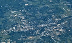
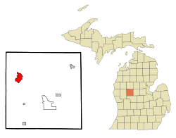
Big Rapids is in northwestern Mecosta County in central Michigan. It is 56 miles (90 km) north of Grand Rapids and 42 miles (68 km) south of Cadillac, both via U.S. Route 131. The city sits along the Muskegon River, which passes Ferris State University and the local middle school on its way southwest to Lake Michigan. As with most of the area, Big Rapids lies on an ancient sea bed and has a sandy subsoil which lies above an iron ore base.
According to the United States Census Bureau, the city has a total area of 4.56 square miles (11.81 km2), of which 4.45 square miles (11.53 km2) are land and 0.12 square miles (0.31 km2), or 2.56%, are water. [1]
The city levies an income tax of 1 percent on residents and 0.5 percent on nonresidents. [7]
The Fred Meijer White Pine Trail, a 92-mile (148 km) multi-use trail from Grand Rapids to Cadillac, passes through Big Rapids.
Census | Pop. | Note | %± |
---|---|---|---|
1870 | 1,237 | — | |
1880 | 3,552 | 187.1% | |
1890 | 5,303 | 49.3% | |
1900 | 4,686 | −11.6% | |
1910 | 4,519 | −3.6% | |
1920 | 4,558 | 0.9% | |
1930 | 4,671 | 2.5% | |
1940 | 4,987 | 6.8% | |
1950 | 6,736 | 35.1% | |
1960 | 8,686 | 28.9% | |
1970 | 11,995 | 38.1% | |
1980 | 14,361 | 19.7% | |
1990 | 12,603 | −12.2% | |
2000 | 10,849 | −13.9% | |
2010 | 10,601 | −2.3% | |
2020 | 7,727 | −27.1% | |
U.S. Decennial Census [9] |
Big Rapids' population peaked in the 1980s. Since the 1980s, Big Rapids has lost over 46% of its population. [3] There are a number of reasons for the decline, one being the decline in enrollment at Ferris State University. [10] Quality of life concerns have also played a role. Mecosta County (like most rural areas) [11] struggles with poor education, lack of high-paying jobs, and high rates of substance abuse. [12]
As of the census of 2020, there were 7,727 people, 3,085 households, and 1,044 families living in the city. The population density was 1,738.4 inhabitants per square mile (671.2/km2). There were 3,590 housing units at an average density of 806.7 inhabitants per square mile (311.5/km2). The racial makeup of the city was 83% White, 5.8% African American, 0.5% Native American, 2.1% Asian, 1.4% from other races, and 7.2% from two or more races. Hispanic or Latino of any race were 5.1% of the population.
There were 3,085 households, of which 22.3% had children under the age of 18 living with them, 21.5% were married couples living together, 10% had a female householder with no husband present, 2.4% had a male householder with no wife present, and 66.2% were non-families. 42.3% of all households were made up of individuals, and 13.5% had someone living alone who was 65 years of age or older. The average household size was 2.09 and the average family size was 2.91.
The median age of the city was 22 years. 12.8% of residents were under the age of 18; 51.2% were between the ages of 18 and 24; 17.6% were from 25 to 44; 10.7% were from 45 to 64; and 7.7% were 65 years of age or older. The gender makeup of the city was 53.7% male and 46.3% female.
As of the census [13] of 2010, there were 10,601 people, 3,330 households, and 1,323 families living in the city. The population density was 2,431.4 inhabitants per square mile (938.8/km2). There were 3,623 housing units at an average density of 831.0 per square mile (320.9/km2). The racial makeup of the city was 88.0% White, 6.8% African American, 0.7% Native American, 1.5% Asian, 0.6% from other races, and 2.5% from two or more races. Hispanic or Latino of any race were 2.4% of the population.
There were 3,330 households, of which 22.2% had children under the age of 18 living with them, 22.9% were married couples living together, 12.7% had a female householder with no husband present, 4.2% had a male householder with no wife present, and 60.3% were non-families. 36.5% of all households were made up of individuals, and 9.8% had someone living alone who was 65 years of age or older. The average household size was 2.22 and the average family size was 2.88.
The median age in the city was 21.8 years. 12.5% of residents were under the age of 18; 54% were between the ages of 18 and 24; 15.9% were from 25 to 44; 11.2% were from 45 to 64; and 6.5% were 65 years of age or older. The gender makeup of the city was 51.0% male and 49.0% female.
This climatic region has large seasonal temperature differences, with warm to hot (and often humid) summers and cold (sometimes severely cold) winters. According to the Köppen Climate Classification system, Big Rapids has a humid continental climate, abbreviated "Dfb" on climate maps. [14]
Climate data for Big Rapids Water Treatment Plant, Michigan (1991–2020 normals, extremes 1896–present) | |||||||||||||
---|---|---|---|---|---|---|---|---|---|---|---|---|---|
Month | Jan | Feb | Mar | Apr | May | Jun | Jul | Aug | Sep | Oct | Nov | Dec | Year |
Record high °F (°C) | 61 (16) | 64 (18) | 85 (29) | 89 (32) | 93 (34) | 99 (37) | 103 (39) | 101 (38) | 97 (36) | 88 (31) | 76 (24) | 66 (19) | 103 (39) |
Average high °F (°C) | 28.2 (−2.1) | 31.4 (−0.3) | 42.0 (5.6) | 54.8 (12.7) | 67.6 (19.8) | 77.2 (25.1) | 81.3 (27.4) | 79.0 (26.1) | 71.6 (22.0) | 58.1 (14.5) | 44.1 (6.7) | 33.2 (0.7) | 55.7 (13.2) |
Daily mean °F (°C) | 20.4 (−6.4) | 21.8 (−5.7) | 30.9 (−0.6) | 42.9 (6.1) | 55.4 (13.0) | 65.1 (18.4) | 69.2 (20.7) | 67.0 (19.4) | 59.3 (15.2) | 47.2 (8.4) | 35.8 (2.1) | 26.3 (−3.2) | 45.1 (7.3) |
Average low °F (°C) | 12.7 (−10.7) | 12.2 (−11.0) | 19.8 (−6.8) | 30.9 (−0.6) | 43.2 (6.2) | 53.0 (11.7) | 57.1 (13.9) | 55.0 (12.8) | 46.9 (8.3) | 36.3 (2.4) | 27.5 (−2.5) | 19.3 (−7.1) | 34.5 (1.4) |
Record low °F (°C) | −30 (−34) | −36 (−38) | −24 (−31) | 1 (−17) | 20 (−7) | 28 (−2) | 32 (0) | 32 (0) | 16 (−9) | 10 (−12) | −8 (−22) | −18 (−28) | −36 (−38) |
Average precipitation inches (mm) | 2.43 (62) | 1.97 (50) | 2.57 (65) | 3.95 (100) | 3.76 (96) | 3.36 (85) | 3.48 (88) | 4.24 (108) | 3.02 (77) | 3.76 (96) | 3.05 (77) | 2.33 (59) | 37.92 (963) |
Average snowfall inches (cm) | 17.8 (45) | 16.0 (41) | 7.7 (20) | 1.5 (3.8) | 0.0 (0.0) | 0.0 (0.0) | 0.0 (0.0) | 0.0 (0.0) | 0.0 (0.0) | 0.2 (0.51) | 3.8 (9.7) | 14.3 (36) | 61.3 (156) |
Average precipitation days (≥ 0.01 in) | 16.5 | 12.9 | 11.6 | 13.5 | 13.0 | 10.7 | 10.5 | 11.3 | 11.5 | 14.7 | 13.7 | 14.9 | 154.8 |
Average snowy days (≥ 0.1 in) | 13.8 | 10.0 | 5.1 | 1.4 | 0.0 | 0.0 | 0.0 | 0.0 | 0.0 | 0.2 | 3.4 | 9.8 | 43.7 |
Source: NOAA [15] [16] |
Osceola County is a county in the U.S. state of Michigan. As of the 2020 United States Census, the population was 22,891. The county seat is Reed City.
Mecosta County is a county located in the U.S. state of Michigan. As of the 2020 Census, the population was 39,714. The county seat is Big Rapids.
Alma is the largest city in Gratiot County in the U.S. state of Michigan. The population was 9,488 at the 2020 census. It was incorporated as the Village of Alma in 1872 and became a city in 1905.
Iron River is a city in Iron County in the U.S. state of Michigan. As of the 2020 census, the city population was 3,007. The city is situated at the southeast corner of Iron River Township, but is administratively autonomous. Iron River is the birthplace and home of four-time US Olympian and 2022 gold medalist Nick Baumgartner.
Rockford is a city in Kent County in the U.S. state of Michigan. The population was 5,719 at the 2010 census.
Barryton is a village in Mecosta County in the U.S. state of Michigan. The population was 405 at the 2020 census, up from 355 in 2010. The village is located in Fork Township on M-66.
Big Rapids Township is a charter township of Mecosta County in the U.S. state of Michigan. As of the 2000 census, the township population was 3,249.
Canadian Lakes is an unincorporated community in Mecosta County in the U.S. state of Michigan. The area is mostly within the southwest portion of Morton Township, southwest of Mecosta and east of Stanwood.
Colfax Township is a civil township of Mecosta County in the U.S. state of Michigan. The population was 1,975 at the 2000 census.
Green Charter Township is a charter township of Mecosta County in the U.S. state of Michigan. As of the 2000 census, the township population was 3,209. The township was organized in 1858, before Mecosta County was detached from Newaygo County.
Hinton Township is a civil township of Mecosta County in the U.S. state of Michigan. As of the 2000 census, the township population was 1,035. John Hinton was the first white settler here in 1855. The township was named for him when it was organized in 1860. A post office named Hinton operated from July 1862 until October 1863.
Mecosta is a village in Mecosta County in the U.S. state of Michigan. The population was 457 at the 2010 census. The village is within Morton Township. Mecosta Township, which is also in Mecosta county, is located several miles to the west.
Mecosta Township is a civil township of Mecosta County in Michigan. The population was 2,435 in accordance with the 2000 census. The Village of Mecosta, which is also in Mecosta County, is in Morton Township, several miles to the east.
Morley is a village in Deerfield Township, Mecosta County in the U.S. state of Michigan. The population was 493 at the 2010 census.
Morton Township is a civil township of Mecosta County in the U.S. state of Michigan. The population was 3,597 at the 2000 census.
Stanwood is a village in Mecosta County of the U.S. state of Michigan. The population was 211 at the 2010 census. The village is within Mecosta Township.
Lakeview is a village in Cato Township in Montcalm County of the U.S. state of Michigan. The population was 1,007 at the 2010 census. The village is within Cato Township.
Newaygo is a rural city in Newaygo County in the U.S. state of Michigan. The population was 2,471 at the 2020 census.
Deerfield Township is a civil township of Mecosta County in the U.S. state of Michigan. The population was 1,630 at the 2000 census.
Wheatland Township is a civil township of Mecosta County in the U.S. state of Michigan. The population was 1,474 at the 2000 census.