Fork Township, Michigan

Last updated

Fork Township, Michigan
USA Michigan location map.svg
Red pog.svg
Fork Township
Location within the state of Michigan
Usa edcp location map.svg
Red pog.svg
Fork Township
Fork Township (the United States)
Coordinates: 43°46′5″N85°8′23″W / 43.76806°N 85.13972°W / 43.76806; -85.13972
Country United States
State Michigan
County Mecosta
Area
[1]
  Total35.2 sq mi (91 km2)
  Land34.8 sq mi (90 km2)
  Water0.4 sq mi (1 km2)
Elevation
981 ft (299 m)
Population
 (2020) [2]
  Total1,627
  Density46.8/sq mi (18.1/km2)
Time zone UTC-5 (Eastern (EST))
  Summer (DST) UTC-4 (EDT)
ZIP Codes
49305 (Barryton)
49679 (Sears)
48632 (Lake)
FIPS code 26-107-29680 [3]
GNIS feature ID1626298 [4]
Website forktownshipmichigan.com

Fork Township is a civil township of Mecosta County in the U.S. state of Michigan. The population was 1,627 at the 2020 census. [2]

Contents

History

Fork Township was organized in 1867. [5]

Communities

Geography

Fork Township occupies the northeast corner of Mecosta County, with Osceola County bordering the township to the north, Isabella County bordering it to the east, and Clare County touching the township's northeast corner. The village of Barryton is in the southern part of the township. State highway M-66 crosses the township from south to north.

According to the United States Census Bureau, Fork Township has a total area of 35.2 square miles (91 km2), of which 34.8 square miles (90 km2) are land and 0.4 square miles (1.0 km2), or 1.20%, are water. [1] The township is drained by the North Branch and West Branch of the Chippewa River, which is formed by their confluence in Barryton.

Demographics

As of the census [3] of 2000, there were 1,678 people, 669 households, and 487 families residing in the township. The population density was 48.0 inhabitants per square mile (18.5/km2). There were 950 housing units at an average density of 27.2 per square mile (10.5/km2). The racial makeup of the township was 97.62% White, 0.77% African American, 0.48% Native American, and 1.13% from two or more races. Hispanic or Latino of any race were 1.37% of the population.

There were 669 households, out of which 29.1% had children under the age of 18 living with them, 58.9% were married couples living together, 9.1% had a female householder with no husband present, and 27.1% were non-families. 23.3% of all households were made up of individuals, and 11.4% had someone living alone who was 65 years of age or older. The average household size was 2.50 and the average family size was 2.91.

In the township the population was spread out, with 25.4% under the age of 18, 6.4% from 18 to 24, 24.3% from 25 to 44, 26.1% from 45 to 64, and 17.8% who were 65 years of age or older. The median age was 41 years. For every 100 females, there were 96.9 males. For every 100 females age 18 and over, there were 94.6 males.

The median income for a household in the township was $28,750, and the median income for a family was $31,486. Males had a median income of $27,105 versus $21,397 for females. The per capita income for the township was $14,124. About 11.9% of families and 14.8% of the population were below the poverty line, including 22.4% of those under age 18 and 5.2% of those age 65 or over.

Related Research Articles

<span class="mw-page-title-main">Lake Charter Township, Michigan</span> Charter township in Michigan, United States

Lake Charter Township is a charter township of Berrien County in the U.S. state of Michigan. The population was 2,972 at the 2010 census.

<span class="mw-page-title-main">Dwight Township, Michigan</span> Civil township in Michigan, United States

Dwight Township is a civil township of Huron County in the U.S. state of Michigan. The population was 930 at the 2000 census.

<span class="mw-page-title-main">Gilmore Township, Isabella County, Michigan</span> Civil township in Michigan, United States

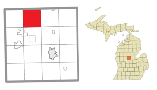
Gilmore Township is a civil township of Isabella County in the U.S. state of Michigan. The population was 1,376 at the 2000 census.

<span class="mw-page-title-main">Nottawa Township, Isabella County, Michigan</span> Civil township in Michigan, United States

Nottawa Township is a civil township of Isabella County in the U.S. state of Michigan. The population was 2,225 at the 2020 census.

<span class="mw-page-title-main">Rolland Township, Michigan</span> Civil township in Michigan, United States

Rolland Township is a civil township of Isabella County in the U.S. state of Michigan. The population was 1,210 at the 2000 census.

<span class="mw-page-title-main">Barryton, Michigan</span> Village in Michigan, United States

Barryton is a village in Mecosta County in the U.S. state of Michigan. The population was 405 at the 2020 census, up from 355 in 2010. The village is located in Fork Township on M-66.

Chippewa Township is a civil township of Mecosta County in the U.S. state of Michigan. As of the 2020 census, the township population was 1,227.

Colfax Township is a civil township of Mecosta County in the U.S. state of Michigan. The population was 1,962 at the 2020 census.

Grant Township is a civil township of Mecosta County in the U.S. state of Michigan. As of the 2020 census, the township population was 702.

Green Charter Township is a charter township of Mecosta County in the U.S. state of Michigan. As of the 2020 census, the township population was 3,219. The township was organized in 1858, before Mecosta County was detached from Newaygo County.

Hinton Township is a civil township of Mecosta County in the U.S. state of Michigan. As of the 2020 census, the township population was 1,054.

Mecosta Township is a civil township of Mecosta County in Michigan. The population was 2,435 in accordance with the 2000 census. The Village of Mecosta, which is also in Mecosta County, is in Morton Township, several miles to the east.

<span class="mw-page-title-main">Lakeview, Michigan</span> Village in Michigan, United States

Lakeview is a village in Cato Township in Montcalm County of the U.S. state of Michigan. The population was 1,007 at the 2010 census. The village is within Cato Township.

<span class="mw-page-title-main">Pierson, Michigan</span> Village in Michigan, United States

Pierson is a village in Montcalm County of the U.S. state of Michigan. The population was 172 at the 2010 census. The village is within Pierson Township.

Croton Township is a civil township of Newaygo County in the U.S. state of Michigan. The population was 3,042 at the 2000 census. Known as the "Party Capital" of Mid-Michigan, Croton lies on the banks of the majestic Muskegon River. Nestled between the Croton Dam and Hardy Dam, an artificial lake is created which plays hosts to world-class fishing, boating, and natural scenery. Often, referred to as "Michigan's Secret Paradise" Croton is lauded as a quiet get away, especially during the warm summer months.

<span class="mw-page-title-main">Brockway Township, Michigan</span> Civil township in Michigan, United States

Brockway Township is a civil township of St. Clair County in the U.S. state of Michigan. As of the 2010 Census, the township population was 2,022.

Aetna Township is a civil township of Mecosta County in the U.S. state of Michigan. As of the 2020 census, the township population was 2,241.

Austin Township is a civil township of Mecosta County in the U.S. state of Michigan. As of the 2020 census, the township population was 1,715.

Deerfield Township is a civil township of Mecosta County in the U.S. state of Michigan. The population was 1,785 at the 2020 census.

Wheatland Township is a civil township of Mecosta County in the U.S. state of Michigan. The population was 1,474 at the 2000 census.

References

Notes

  1. 1 2 "2022 U.S. Gazetteer Files: Michigan". United States Census Bureau. Retrieved September 13, 2023.
  2. 1 2 "P1. Race – Fork township, Michigan: 2020 DEC Redistricting Data (PL 94-171)". U.S. Census Bureau. Retrieved September 13, 2023.
  3. 1 2 "U.S. Census website". United States Census Bureau . Retrieved January 31, 2008.
  4. U.S. Geological Survey Geographic Names Information System: Fork Township, Michigan
  5. Romig 1986, p. 203.
  6. Romig 1986, p. 149.

Sources