In 1836 Charles Noble knew that Michigan would be seeking a central location for a new capital when it became a state. He purchased an area of forest, cleared 20 acres (81,000 m2), and founded Mason Center. The "Center" was soon dropped. In 1847, however, the state chose Lansing Township 12 miles (19km) northward to be its capital due to its potential for water power. Noble managed to make Mason the county seat instead. Ingham County's first downtown courthouse was built in 1843, and was replaced in 1858, and the economy thrived in the first decades based on sawmills, carriage and cart factories, copper shops, a steam flourmill and a buffalo robe manufacturer. In 1865, Mason was incorporated as a village; in 1875 the town became a city. In the 1800s, Mason was the center of Ingham County activity, even more than was Lansing, the state capital. In 1877, Lansing attempted to take the status of county seat for itself, but the two cities made an agreement that moved some county offices and courts to Lansing in exchange for Mason remaining the county seat. As a result, Michigan is the only state in the country with a capital city that is not also a county seat.
Up into the early 1900s, the local Ojibwa tribe had a visible presence in the town. In the 1900s, The Wyeth Corporation began producing baby formula in Mason, but that was discontinued in the 1990s. Today, it is home to the headquarters of Dart Container Corporation. Michigan Packaging Company, Gestamp Hardtech, and Ingham Intermediate School District also have facilities in the Mason area. Cattle can still be seen grazing within the city limits.[5]
Geography
According to the United States Census Bureau, the city has a total area of 5.13 square miles (13.29km2), of which 5.10 square miles (13.21km2) is land and 0.03 square miles (0.08km2) is water.[6]Sycamore Creek flows through the city.[7]
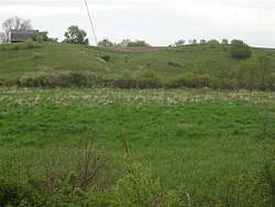
A part of the Mason Esker
Mason sits upon the Mason Esker, which is one of the longest eskers in the western hemisphere.[8]
The Capital Area Transportation Authority (CATA) provides bus service from Lansing to Mason. Route 46 runs weekdays from downtown Lansing to the southside of Mason. The Mason Connector runs weekdays and Saturday from south Lansing to Mason.[9]
Jewett Field is a general aviation airport located southeast of Mason. Scheduled passenger air carrier flights are provided by Capital Region International Airport located at the northwest corner of Ingham County.
As of the census[11] of 2010, there were 8,252 people, 3,278 households, and 2,032 families residing in the city. The population density was 1,618.0 inhabitants per square mile (624.7/km2). There were 3,574 housing units at an average density of 700.8 per square mile (270.6/km2). The racial makeup of the city was 90.2% White, 5.9% African American, 0.4% Native American, 0.9% Asian, 0.8% from other races, and 1.7% from two or more races. Hispanic or Latino of any race were 3.7% of the population.
There were 3,278 households, of which 30.4% had children under the age of 18 living with them, 44.8% were married couples living together, 13.3% had a female householder with no husband present, 3.9% had a male householder with no wife present, and 38.0% were non-families. 32.6% of all households were made up of individuals, and 11.6% had someone living alone who was 65 years of age or older. The average household size was 2.29 and the average family size was 2.91.
The median age in the city was 37.8 years. 21.8% of residents were under the age of 18; 9.6% were between the ages of 18 and 24; 29.5% were from 25 to 44; 25.7% were from 45 to 64; and 13.5% were 65 years of age or older. The gender makeup of the city was 50.8% male and 49.2% female.
2000 census
As of the census[3] of 2000, there were 6,714 people, 2,806 households, and 1,826 families residing in the city. The population density was 1,466.6 inhabitants per square mile (566.3/km2). There were 2,961 dwelling units at an average density of 646.8 per square mile (249.7/km2). The racial makeup of the city was 95.98% White, 0.64% African American, 0.46% Native American, 0.71% Asian, 0.74% from other races, and 1.46% from two or more races. Hispanic or Latino of any race were 2.73% of the population.
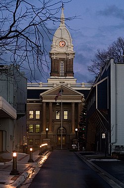
Ingham County Courthouse
There were 2,806 households, out of which 33.0% had children under the age of 18 living with them, 48.7% were married couples living together, 12.5% had a female householder with no husband present, and 34.9% were non-families. 30.4% of all households were made up of individuals, and 11.0% had someone living alone who was 65 years of age or older. The average household size was 2.38 and the average family size was 2.96.
In the city, the population was spread out, with 25.6% under the age of 18, 8.3% from 18 to 24, 30.7% from 25 to 44, 22.0% from 45 to 64, and 13.4% who were 65 years of age or older. The median age was 36 years. For every 100 females, there were 89.8 males. For every 100 females age 18 and over, there were 85.0 males.
The median income for a household in the city was $41,790, and the median income for a family was $53,519. Males had a median income of $41,081 versus $26,266 for females. The per capita income for the city was $20,866. About 1.3% of families and 4.1% of the population were below the poverty line, including 1.7% of those under age 18 and 7.6% of those age 65 or over
Economy
The Mason area is home to Dart Container Corporation, the largest manufacturer of foam cups and containers in the world. Dart is known for being vertically integrated, and is one of the largest privately owned corporations in Michigan. Dart Container also owns Solo.
↑Field Manual of Soil Engineering. Michigan. State Highway Dept. 1952. p.8. The longest esker in Michigan is called the Mason esker and it extends from the outskirts of Lansing to a point beyond Mason
This page is based on this Wikipedia article Text is available under the CC BY-SA 4.0 license; additional terms may apply. Images, videos and audio are available under their respective licenses.