Bad Axe, Michigan

Last updated
Bad Axe, Michigan
Bad Axe, Michigan along M-142.jpg
Looking west along M-142 toward M-53
Bad Axe, MI location.png
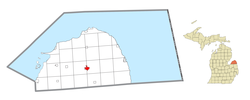
Location within Huron County
USA Michigan location map.svg
Red pog.svg
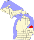
Bad Axe
Location within the state of Michigan
Coordinates: 43°48′10″N82°59′59″W / 43.80278°N 82.99972°W / 43.80278; -82.99972
Country United States
State Michigan
County Huron
Incorporated1905 (city)
Government
   Mayor Kathleen Particka
Area
[1]
  Total2.33 sq mi (6.03 km2)
  Land2.33 sq mi (6.03 km2)
  Water0.00 sq mi (0.00 km2)
Elevation
758 ft (231 m)
Population
 (2020)
  Total3,021
  Density1,297.68/sq mi (501.09/km2)
Time zone UTC-5 (Eastern (EST))
  Summer (DST) UTC-4 (EDT)
ZIP code(s)
48413
Area code 989
FIPS code 26-04740 [2]
GNIS feature ID0620421 [3]
Website Official website

Bad Axe is a city in the U.S. state of Michigan and the county seat of Huron County [4] in the Thumb region of the Lower Peninsula. The population was 3,021 at the 2020 census, making it the largest community in Huron County and second largest in the Upper Thumb, after Caro.

Contents

History

The city was established in 1905. [5] The city's unusual name [6] dates to the time of its settlement. While surveying the first state road through the Huron County wilderness in 1861, Rudolph Papst and George Willis Pack made camp at the future site of the city and found a much-used and badly damaged axe. At Pack's suggestion, Papst used the name “Bad Axe Camp” in the minutes of the survey and on a sign he placed along the main trail. [7] [8] The first post office in Bad Axe was established in 1870. [9]

Geography

According to the United States Census Bureau, the city has an area of 2.26 square miles (5.85 km2), all land. [10]

Climate

This climatic region has large seasonal temperature differences, with warm to hot (and often humid) summers and cold (sometimes severely cold) winters. According to the Köppen Climate Classification system, Bad Axe has a humid continental climate, abbreviated "Dfb" on climate maps. [11]


Demographics

Historical population
CensusPop.Note
1880 190
1890 842343.2%
1900 1,24147.4%
1910 1,55925.6%
1920 2,14037.3%
1930 2,3329.0%
1940 2,62412.5%
1950 2,97313.3%
1960 2,9980.8%
1970 2,9990.0%
1980 3,1846.2%
1990 3,4849.4%
2000 3,462−0.6%
2010 3,129−9.6%
2020 3,021−3.5%
U.S. Decennial Census [12]

2010 census

As of the census [13] of 2010, there were 3,129 people, 1,358 households, and 760 families residing in the city. The population density was 1,384.5 inhabitants per square mile (534.6/km2). There were 1,546 housing units at an average density of 684.1 per square mile (264.1/km2). The city's racial makeup was 95.1% White, 0.8% African American, 0.9% Native American, 1.5% Asian, 0.4% from other races, and 1.2% from two or more races. Hispanic or Latino of any race were 2.4% of the population.

There were 1,358 households, of which 27.5% had children under the age of 18 living with them, 36.8% were married couples living together, 14.7% had a female householder with no husband present, 4.4% had a male householder with no wife present, and 44.0% were non-families. 38.7% of all households were made up of individuals, and 17% had someone living alone who was 65 years of age or older. The average household size was 2.16 and the average family size was 2.81.

The median age in the city was 42.9 years. 21.3% of residents were under the age of 18; 8.3% were between the ages of 18 and 24; 23.2% were from 25 to 44; 26.6% were from 45 to 64; and 20.5% were 65 years of age or older. The city's gender makeup was 46.5% male and 53.5% female.

2000 census

As of the census [2] of 2000, there were 3,462 people, 1,418 households, and 877 families residing in the city. The population density was 1,617.3 inhabitants per square mile (624.4/km2). There were 1,545 housing units at an average density of 721.8 per square mile (278.7/km2). The city's racial makeup was 97.57% White, 0.26% African American, 0.26% Native American, 0.58% Asian, 0.38% from other races, and 0.95% from two or more races. Hispanic or Latino of any race were 1.53% of the population.

There were 1,418 households, of which 31.7% had children under the age of 18 living with them, 45.3% were married couples living together, 12.9% had a female householder with no husband present, and 38.1% were non-families. 33.5% of all households were made up of individuals, and 15.1% had someone living alone who was 65 years of age or older. The average household size was 2.31 and the average family size was 2.95.

In the city, the population was spread out, with 24.2% under the age of 18, 8.5% from 18 to 24, 27.5% from 25 to 44, 21.6% from 45 to 64, and 18.3% who were 65 years of age or older. The median age was 39 years. For every 100 females, there were 87.5 males. For every 100 females age 18 and over, there were 85.1 males.

The city's median household income was $32,125, and the median family income was $42,650. Males had a median income of $34,758 versus $20,288 for females. The city's per capita income was $17,465. About 9.3% of families and 14.1% of the population were below the poverty line, including 16.1% of those under age 18 and 14.3% of those age 65 or over.

Education

Bad Axe is served by Bad Axe Public Schools, which consist of: [14]

The district's George E. Greene Elementary School was shut down in 2011; Ascent High School, an alternative high school, is in its former building. The Bad Axe Elementary School is currently in the building which the district's Intermediate School occupied.

Media

Radio

Local radio stations licensed to serve Bad Axe are commercial broadcasters WLEW-AM and WLEW-FM.

Newspapers

Broadcast television

Huron County lies inside the Flint/Tri-Cities Television Market. Only stations available on Comcast in the Bad Axe area are listed below.

Infrastructure

Transportation

Notable people

Climate data for Bad Axe, Michigan (1991–2020 normals, extremes 1925–present)
MonthJanFebMarAprMayJunJulAugSepOctNovDecYear
Record high °F (°C)64
(18)
66
(19)
85
(29)
89
(32)
92
(33)
100
(38)
103
(39)
101
(38)
97
(36)
91
(33)
80
(27)
69
(21)
103
(39)
Mean daily maximum °F (°C)28.3
(−2.1)
30.2
(−1.0)
40.0
(4.4)
53.3
(11.8)
66.1
(18.9)
76.0
(24.4)
80.3
(26.8)
78.5
(25.8)
72.0
(22.2)
58.7
(14.8)
45.3
(7.4)
34.0
(1.1)
55.2
(12.9)
Daily mean °F (°C)21.9
(−5.6)
22.9
(−5.1)
31.6
(−0.2)
43.2
(6.2)
55.3
(12.9)
65.4
(18.6)
69.9
(21.1)
68.5
(20.3)
61.5
(16.4)
50.0
(10.0)
38.4
(3.6)
28.5
(−1.9)
46.4
(8.0)
Mean daily minimum °F (°C)15.6
(−9.1)
15.6
(−9.1)
23.3
(−4.8)
33.1
(0.6)
44.6
(7.0)
54.8
(12.7)
59.5
(15.3)
58.5
(14.7)
51.0
(10.6)
41.3
(5.2)
31.4
(−0.3)
22.9
(−5.1)
37.6
(3.1)
Record low °F (°C)−23
(−31)
−22
(−30)
−15
(−26)
8
(−13)
22
(−6)
28
(−2)
35
(2)
34
(1)
26
(−3)
15
(−9)
−7
(−22)
−8
(−22)
−23
(−31)
Average precipitation inches (mm)1.96
(50)
1.88
(48)
1.83
(46)
3.19
(81)
3.34
(85)
3.17
(81)
3.67
(93)
3.36
(85)
3.16
(80)
2.90
(74)
2.36
(60)
2.07
(53)
32.89
(835)
Average precipitation days (≥ 0.01 in)14.711.210.211.612.210.49.710.010.713.312.413.5139.9
Source: NOAA [15] [16]

Related Research Articles

<span class="mw-page-title-main">Huron County, Michigan</span> County in Michigan, United States

Huron County is a county in the U.S. state of Michigan. As of the 2020 Census, the population was 31,407. The county seat is Bad Axe. Huron County is at the northern tip of the Thumb, which is a sub region of Mid Michigan. It is a peninsula, bordered by Saginaw Bay to the west and Lake Huron to the north and east, and has over 90 miles (140 km) of shoreline, from White Rock on Lake Huron to Sebewaing on the Saginaw Bay. Huron County's most prominent industry is agriculture, as with most of the other Thumb counties. Huron County enjoys seasonal tourism from large cities such as Detroit, Flint, and Saginaw. Much of the tourism is in the Port Austin and Caseville area.

<span class="mw-page-title-main">Greenbush Township, Alcona County, Michigan</span> Civil township in Michigan, United States

Greenbush Township is a civil township of Alcona County in the U.S. state of Michigan. The population was 1,270 at the 2020 census. The population in 2021 is estimated to be 1,281.

<span class="mw-page-title-main">Cheboygan, Michigan</span> City in Michigan, United States

Cheboygan is a city in the U.S. state of Michigan. It is the county seat and largest settlement of Cheboygan County. At the 2020 census, Cheboygan had a population 4,770.

<span class="mw-page-title-main">Colfax Township, Huron County, Michigan</span> Civil township in Michigan, United States

Colfax Township is a civil township of Huron County in the U.S. state of Michigan. The population was 1,954 at the 2000 census.

<span class="mw-page-title-main">Harbor Beach, Michigan</span> City in Michigan, United States

Harbor Beach is a city in Huron County in the U.S. state of Michigan. The population was 1,604 at the 2020 census.

<span class="mw-page-title-main">Sebewaing, Michigan</span> Village in Michigan, United States

Sebewaing (SEE-bah-wing) is a village in Huron County in the U.S. state of Michigan. The population was 1,721 at the 2020 census. The village is within Sebewaing Township. This community is known as the Sugar Beet Capital, due to the Michigan Sugar slicing mill located within the village and the yearly Michigan Sugar Festival. The Sebewaing area, the Thumb, and the state of Michigan overall are major beet sugar producers, mostly for domestic consumption. Sebewaing is also the first gigabit village in the state of Michigan. In 2014–15, Sebewaing completed its fiber to the home network, offering up to gigabit/second speeds over their fiber optic network.

<span class="mw-page-title-main">Sheridan Township, Huron County, Michigan</span> Civil township in Michigan, United States

Sheridan Township is a civil township of Huron County in the U.S. state of Michigan. The population was 736 at the 2000 census.

<span class="mw-page-title-main">Verona Township, Michigan</span> Civil township in Michigan, United States

Verona Township is a civil township of Huron County in the U.S. state of Michigan. The population was 1,349 at the 2000 census.

Au Sable is an unincorporated community and census-designated place (CDP) in Iosco County, Michigan. The population of the CDP was 1,453 at the 2020 census. The community is located within Au Sable Township at the mouth of the Au Sable River along Lake Huron.

<span class="mw-page-title-main">Mount Clemens, Michigan</span> City in Michigan, United States

Mount Clemens is a city in the U.S. state of Michigan. The population was 15,697 at the 2020 census. It is the seat of government of Macomb County.

<span class="mw-page-title-main">Lake City, Michigan</span> City in Michigan, United States

Lake City is a city in the U.S. state of Michigan. It is the county seat of Missaukee County, and is the largest city within the county. The city is located in the Northern Lower Peninsula of Michigan. As of the 2020 census, the population of Lake City was 829. Lake City has been nicknamed "Michigan's Christmas Tree Capital", due to the high number of farms near the city.

<span class="mw-page-title-main">Berlin Charter Township, Michigan</span> Charter township in Michigan, United States

Berlin Charter Township is a charter township of Monroe County in the U.S. state of Michigan. At the 2020 census, the township population was 9,890.

<span class="mw-page-title-main">South Rockwood, Michigan</span> Village in Michigan, United States

South Rockwood is a village in Monroe County in the U.S. state of Michigan. The population was 1,587 at the 2020 census. The village is located within Berlin Charter Township.

<span class="mw-page-title-main">Atlanta, Michigan</span> Census-designated place in Michigan, United States

Atlanta is a census-designated place and unincorporated community in the U.S. state of Michigan. It is the county seat of Montmorency County. The community had a population of 720 at the 2020 census, down from 827 in 2010. Atlanta has been nicknamed the "Elk Capital of Michigan".

<span class="mw-page-title-main">Sandusky, Michigan</span> City in Michigan, United States

Sandusky is a city in the U.S. state of Michigan. The population was 2,679 at the 2010 census. It is the county seat of Sanilac County, as well as the most populous city in the county.

<span class="mw-page-title-main">Vassar, Michigan</span> City in Michigan, United States

Vassar is a city in Tuscola County in the U.S. state of Michigan. Founded March 1, 1849. The population was 2,727 at the 2020 census and 2,697 in 2010. The city is located on the western edge of Vassar Township but is administratively autonomous.

<span class="mw-page-title-main">Flat Rock, Michigan</span> City in Michigan, United States

Flat Rock is a city in Wayne County, Michigan, United States, with a small portion of the city extending into Monroe County. At the 2020 census, the population was 10,541.

<span class="mw-page-title-main">Milford, Michigan</span> Village in Michigan, United States

Milford is a village in Oakland County in the U.S. state of Michigan. The population was 6,175 at the time of the 2010 census. The village is located within Milford Township. The village is known for being the home of the Milford General Motors Proving Ground.

<span class="mw-page-title-main">Port Sanilac, Michigan</span> Village in Michigan, United States

Port Sanilac is a village in Sanilac Township, Sanilac County in the U.S. state of Michigan. The population was 567 at the 2020 census.

Campbell is a town in Steuben County, New York, United States. The population was 3,163 at the 2020 census. The name is from Robert Campbell, an early landowner. The town is centrally located in the county and is northwest of Corning.

References

Notes

  1. "2020 U.S. Gazetteer Files". United States Census Bureau. Retrieved May 21, 2022.
  2. 1 2 "U.S. Census website". United States Census Bureau . Retrieved 2008-01-31.
  3. U.S. Geological Survey Geographic Names Information System: Bad Axe, Michigan
  4. "Find a County". National Association of Counties. Archived from the original on 2011-05-31. Retrieved 2011-06-07.
  5. "City of Bad Axe, Michigan". City of Bad Axe, Michigan. Retrieved August 25, 2012.
  6. Don Voorhees (4 October 2011). The Super Book of Useless Information: The Most Powerfully Unnecessary Things You Never Need to Know. Penguin Group US. p. 67. ISBN   978-1-101-54513-3.
  7. Local History – How Bad Axe got its Name
  8. "Profile for Bad Axe, Michigan, MI". ePodunk. Retrieved August 24, 2012.
  9. Romig 1986, p. 38.
  10. "US Gazetteer files 2010". United States Census Bureau. Archived from the original on 2011-02-20. Retrieved 2012-11-25.
  11. Climate Summary for Bad Axe, Michigan
  12. "Census of Population and Housing". Census.gov. Retrieved June 4, 2015.
  13. "U.S. Census website". United States Census Bureau . Retrieved 2012-11-25.
  14. Bad Axe Public Schools > Home
  15. "NowData - NOAA Online Weather Data". National Oceanic and Atmospheric Administration. Retrieved September 3, 2021.
  16. "Station: Bad Axe, MI". U.S. Climate Normals 2020: U.S. Monthly Climate Normals (1991-2020). National Oceanic and Atmospheric Administration. Retrieved September 3, 2021.

Sources