Hubbardston, Michigan

Last updated
Hubbardston, Michigan
Ionia County Michigan Incorporated and Unincorporated areas Hubbardston Highlighted.svg
Location of Hubbardston, Michigan
Coordinates: 43°05′39″N84°50′31″W / 43.09417°N 84.84194°W / 43.09417; -84.84194 Coordinates: 43°05′39″N84°50′31″W / 43.09417°N 84.84194°W / 43.09417; -84.84194
Country United States
State Michigan
Counties Ionia, Clinton
Area
[1]
  Total1.53 sq mi (3.96 km2)
  Land1.45 sq mi (3.76 km2)
  Water0.07 sq mi (0.19 km2)
Elevation
[2]
712 ft (217 m)
Population
 (2020)
  Total369
  Density253.96/sq mi (98.07/km2)
Time zone UTC-5 (Eastern (EST))
  Summer (DST) UTC-4 (EDT)
ZIP code
48845
Area code 989
FIPS code 26-39660 [3]
GNIS feature ID2398553 [2]

Hubbardston is a village in the U.S. state of Michigan. It is mostly in North Plains Township in Ionia County, and partially in Lebanon Township in Clinton County. Its population was 395 at the 2010 census.

Contents

Geography

According to the United States Census Bureau, the Hubbardston has an area of 1.62 square miles (4.20 km2), of which 1.54 square miles (3.99 km2) is land and 0.08 square miles (0.21 km2) is water. [4]

Demographics

Historical population
CensusPop.Note
1900 450
1910 4500.0%
1920 368−18.2%
1930 344−6.5%
1940 39113.7%
1950 335−14.3%
1960 38113.7%
1970 4035.8%
1980 4214.5%
1990 404−4.0%
2000 394−2.5%
2010 3950.3%
2020 369−6.6%
U.S. Decennial Census [5]

2010 census

As of the 2010 census, [6] Hubbardston had 395 people, 136 households, and 107 families. Its population density was 256.5 inhabitants per square mile (99.0/km2). There were 148 housing units at an average density of 96.1 per square mile (37.1/km2). The racial makeup of the village was 97.2% White, 0.3% African American, 0.3% Asian, 1.5% from other races, and 0.8% from two or more races. Hispanic or Latino of any race were 4.3% of the population.

Of its 136 households, 33.1% had children under the age of 18; 55.9% were married couples living together; 14.7% had a female householder with no husband present; 8.1% had a male householder with no wife present; and 21.3% were non-families. 19.9% of households were people living alone; of these, 5.9% were 65 years of age or older. The average household size was 2.69 and the average family size was 2.87.

The village's median age was 41.8 years. 23% of residents were under the age of 18; 8.9% were 18–24; 24.1% were 25–44; 29.1% were 45–64; and 14.9% were 65 or older. 50.9% were male and 49.1% female.

2000 census

As of the census [3] of 2000, there were 394 people, 130 households, and 99 families residing in the village. The population density was 250.2 inhabitants per square mile (96.6/km2). There were 139 housing units at an average density of 88.3 per square mile (34.1/km2). The racial makeup of the village was 98.22% White, 1.02% Native American, and 0.76% from two or more races. Hispanic or Latino of any race were 0.76% of the population.

There were 130 households, out of which 36.9% had children under the age of 18 living with them, 58.5% were married couples living together, 10.8% had a female householder with no husband present, and 23.8% were non-families. 13.8% of all households were made up of individuals, and 4.6% had someone living alone who was 65 years of age or older. The average household size was 2.84 and the average family size was 3.15.

In the village, the population was spread out, with 26.6% under the age of 18, 7.4% from 18 to 24, 28.4% from 25 to 44, 24.6% from 45 to 64, and 12.9% who were 65 years of age or older. The median age was 36 years. For every 100 females, there were 96.0 males. For every 100 females age 18 and over, there were 97.9 males.

The median income for a household in the village was $36,458, and the median income for a family was $38,750. Males had a median income of $34,688 versus $21,500 for females. The per capita income for the village was $12,690. About 8.8% of families and 11.5% of the population were below the poverty line, including 13.2% of those under age 18 and 5.8% of those age 65 or over.

Related Research Articles

<span class="mw-page-title-main">Hubbardston, Massachusetts</span> Town in Massachusetts, United States

Hubbardston is a town in Worcester County, Massachusetts, United States. As of the 2020 U.S. census, the town population was 4,328. It is situated 18 miles north of Worcester and 53 miles west of Boston; it is distinguished in Massachusetts by being unusually high at 1015 feet above sea level.

<span class="mw-page-title-main">Lebanon Township, Michigan</span> Civil township in Michigan, United States

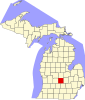
Lebanon Township is a civil township of Clinton County in the U.S. state of Michigan. The population was 605 at the 2010 census.

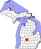
North Plains Township is a large civil township of Ionia County in the U.S. state of Michigan. The population was 1,366 at the 2000 census.

<span class="mw-page-title-main">Applegate, Michigan</span> Village in Michigan, United States

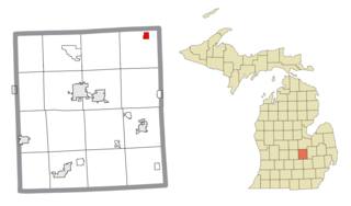
Applegate is a village in Sanilac County of the U.S. state of Michigan. The population was 241 at the 2020 census. Applegate is in the southeast corner of Washington Township on the boundary with Sanilac Township.

<span class="mw-page-title-main">New Lothrop, Michigan</span> Village in Michigan, United States

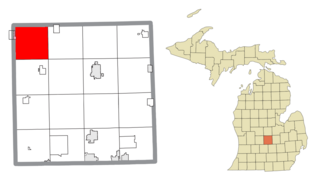
New Lothrop is a village in Shiawassee County in the U.S. state of Michigan. The population was 581 at the 2010 census. The village is located within Hazelton Township.

<span class="mw-page-title-main">Leslie, Missouri</span> Village in Missouri, United States

Leslie is a village in west central Franklin County, Missouri, United States. The population was 171 at the 2010 census.

<span class="mw-page-title-main">Parkway, Missouri</span> Village in Missouri, United States

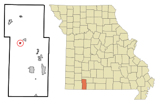
Parkway is a village in Franklin County, Missouri, United States. The population was 439 at the 2010 census.

<span class="mw-page-title-main">Cedar Hill Lakes, Missouri</span> Village in Missouri, United States

Cedar Hill Lakes is a village in Jefferson County, Missouri, United States. The population was 203 at the 2020 census.

<span class="mw-page-title-main">Leawood, Missouri</span> Village in Missouri, United States

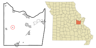
Leawood is a village in Newton County, Missouri, United States. The population was 682 at the 2010 census. It is part of the Joplin, Missouri Metropolitan Statistical Area.

<span class="mw-page-title-main">Velda Village Hills, Missouri</span> Village in Missouri, United States

Velda Village Hills is a village in northeastern St. Louis County, Missouri, United States. The population was 1,055 at the 2010 census.

<span class="mw-page-title-main">McCord Bend, Missouri</span> Village in Missouri, United States

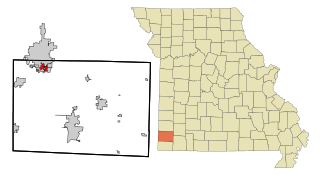
McCord Bend is a village in Stone County, Missouri, United States. The population was 212 at the 2020 census. It is part of the Branson, Missouri Micropolitan Statistical Area.

<span class="mw-page-title-main">Weston, Nebraska</span> Village in Nebraska, United States

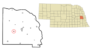
Weston is a village in Saunders County, Nebraska, United States. The population was 324 at the 2010 census.

<span class="mw-page-title-main">Holloway, Ohio</span> Village in Ohio, United States

Holloway is a village in Belmont County, Ohio, United States. The population was 330 at the 2020 census. It is part of the Wheeling metropolitan area. Holloway was laid out in 1883, and named after the local Holloway family.

<span class="mw-page-title-main">Berkey, Ohio</span> Village in Ohio, United States

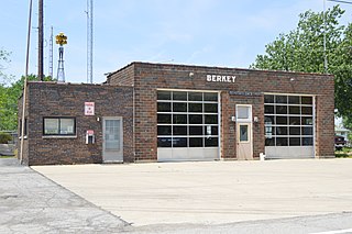
Berkey is a village in Lucas County, Ohio, United States. The population was 237 at the 2010 census.

<span class="mw-page-title-main">Port Jefferson, Ohio</span> Village in Ohio, United States

Port Jefferson is a village in Salem Township, Shelby County, Ohio, United States. The population was 371 at the 2010 census.

<span class="mw-page-title-main">Clearview, West Virginia</span> Village in West Virginia, United States

Clearview is a village in Ohio County, West Virginia, United States. It is part of the Wheeling, West Virginia Metropolitan Statistical Area. The population was 565 at the 2010 census.

<span class="mw-page-title-main">Kekoskee, Wisconsin</span> Village in Wisconsin, United States

Kekoskee is a village in Dodge County, Wisconsin, United States. The population was 161 at the 2010 census.

<span class="mw-page-title-main">Ridgeland, Wisconsin</span> Village in Wisconsin, United States

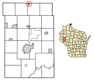
Ridgeland is a village in Dunn County, Wisconsin, United States. The population was 273 at the 2010 census.

<span class="mw-page-title-main">Wilson, Ohio</span> Village in Ohio, United States

Wilson is a village in Belmont and Monroe counties in the U.S. state of Ohio. The population was 129 at the 2020 census. It is part of the Wheeling metropolitan area.

<span class="mw-page-title-main">Wilton, Wisconsin</span> Village in Wisconsin, United States

Wilton is a village in Monroe County, Wisconsin, United States. The population was 504 at the 2010 census. The village is located partially within the Town of Wilton and partially within the Town of Wellington.

References

  1. "2020 U.S. Gazetteer Files". United States Census Bureau. Retrieved May 21, 2022.
  2. 1 2 U.S. Geological Survey Geographic Names Information System: Hubbardston, Michigan
  3. 1 2 "U.S. Census website". United States Census Bureau . Retrieved 2008-01-31.
  4. "US Gazetteer files 2010". United States Census Bureau. Archived from the original on 2012-01-25. Retrieved 2012-11-25.
  5. "Census of Population and Housing". Census.gov. Retrieved June 4, 2015.
  6. "U.S. Census website". United States Census Bureau . Retrieved 2012-11-25.