Midland County is one of 83 counties located in the U.S. state of Michigan. As of the 2020 census, the population was 83,494[2] making it the 24th largest by population in the state. It is the sixth smallest county by area. The county seat is Midland.[3] The name of the county is due to its proximity to the geographical center of the Lower Peninsula. It was founded in 1831; however, it was not until 1855 that the county was effectively organized.[1]
For centuries, the county was home to Native Americans, and Chippewa Indians inhabited the area when the first Europeans made contact.[4]
19th century
In the year of 1831, Midland County's borders had been set.[5] In 1850, Midland County was officially organized.[5] In 1874, the Flint and Pere Marquette Railroad linked Midland to the nationwide railroad network.[4] The City of Midland, the county seat, is officially incorporated in 1887, and 3 years later in 1890, Herbert Henry Dow arrives and founds the Dow Chemical Corporation, today one of the world's largest chemical companies.[4]
Civil War
When the American Civil War broke out in 1861, many men from the county enlisted in the Union Army, many in Company B of the 10th Michigan Volunteer Infantry Regiment, and Company H of the 27th Michigan Volunteer Infantry Regiment, but some ended up in different regiments.[6] Not all of them came back alive and several were wounded. Many veterans of the war are also buried in the county.[7] There were a total of 5 different Posts, or veteran groups, of the Grand Army of the Republic, a Union veterans organization, in Midland County.[8]
In the 20th century the county saw significant growth with the entrenchment of the Dow Chemical Corporation and the establishment of major roads, highways, and a few minor airports. However, in the late 20th century the Pere Marquette Railroad was closed, which cut off passenger train travel from the region.
World War 1
In World War 1, once the US had entered the war in 1917, the Dow Chemical Corporation, based mainly in the city of Midland, was involved with the production of poisonous gases for use during the war, and with the production of ammunition.[9] Additionally, 675 men from Midland joined the US military during the war, and 8 of them died in the line of duty.[10]
World War 2
In World War 2, many men from the county enlisted in the US Military, and several would die. Additionally Dow turned its factories towards supplying the war effort and they would assist in manufacturing explosives, flares, and medicine.[11] There is also a large memorial to veterans from Midland County from this war.
Cold War
During the Cold War, an Army National Guard depot was set up in the city of Midland. In the Vietnam War, Dow and the rest of Midland County were the main suppliers of Napalm used during the conflict.[11] Several men would also die in the Korean War and Vietnam War.
21st century
In the 21st century, the Sons of Union Veterans, the successor to the Grand Army of the Republic, founded the U.S. Grant Camp No. 67, which serves the Midland, Saginaw, and Bay City area.[12][13] During the War on Terror, many men from the county enlisted and few died. The Midland County Veterans Memorial was refurbished. The city of Coleman also built a new war memorial. Curiously, none of these memorials reference the service of Midland men in the Civil War.
In May 2020, Midland County residents in parts of the city of Midland, the village of Sanford, Edenville Township, Midland Township, Tittabawassee, Thomas Township, Saginaw Township, Lincoln Township, Homer Township and Dow Chemical were forced to evacuate due to high flooding which was caused by the breach of the Edenville and Sanford dams.[14]
Geography
Counties adjacent to Midland County
According to the U.S. Census Bureau, the county has a total area of 528 square miles (1,370km2), of which 516 square miles (1,340km2) is land and 12 square miles (31km2) (2.2%) is water.[15] The distance to Saginaw Bay on Lake Huron is less than 40 miles (64km).
The city of Midland, Michigan occupies Midland Charter township. The city's incorporated area extends well into Larkin Township, Homer Township and a small portion of Lincoln Township.
Midland neighborhoods
There are more than 35 neighborhoods within city of Midland according to the neighborhood map on the city's website. There are eight main areas:
Downtown encompasses the central business district and is a hub for commerce, dining, and cultural activities. The Center City includes the historic "Circle", dating from 1938,[16] which was the city's second business district.[17]
North Side neighborhoods north of downtown, often with a mix of residential areas, parks and schools.[18]
Country Club features upscale houses, large lots with trees, highest walkability and bike scores.[19]
Midland West neighborhoods are known as friendly and peaceful with well-maintained properties. It includes the Chippewa and Tittabawassee Rivers, parks and open spaces for recreation, often with a mix of housing styles and mature trees.[20] Upscale Greystone Woods is located there.[21]
East End refers to the area east of downtown, often characterized by a mix of older residential and commercial spaces. A revitalization of Midtown started in 2018, along with Grove Park and surrounding neighborhoods and formation of the Midtown Midland Neighborhood Association.[22][23]
Industrial Park was the former location of Dow Chemical's plants along the Bay City Road corridor. In 2018, Dow Michigan Operations Industrial Park (I-Park), was created on the 2,600 acres (1,100ha; 4.1mi2; 11km2) site that serves multiple companies as a logistics, manufacturing and R&D center for approximately 6,000 employees/contractors. While owned by Dow, it is supported by the Michigan Strategic Fund for modernization that will attract businesses with their utilities, logistics and environmental services.[24]
West Main Street Historic district was established in 1979 to preserve and document Midland's historical structures; specifically blocks and lots within the original Midland plat, offering a glimpse into the city's history. A commission reviews and must approve applications for construction, additions, alterations, repairs, moves, excavations, or demolitions of all properties within the district.[25]
the South is the relatively small area south of the Industrial Park, site of a defunct lumber town (Mapleton) and train depot.[26]
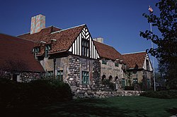
Heritage Park is at the Northwood University campus and an attraction featuring the 1874 Victorian GothicBradley Home; a brine well and the Herbert Dow Museum which is a replication of the Evens Flour Gristmill; and the Carriage House, which contains an operating blacksmith shop and a display of carriages and sleighs, all horse-drawn.[28]
The only other incorporated city in the county is Coleman, Michigan in Warren Township, Michigan. Due to the town's small size (population 1,100) there are no formally defined neighborhoods; commonly recognized areas include the business district, "Stoner's-ville", Little Town, Pere Marquette Senior Estates and an industrial park.[29][30][31]
According to the Midland County website, Pinecrest Farms is a notable development of 160 acres west of the Currie Golf Course. It is a long-term-care facility for the elderly and individuals with mental and/or physical disabilities.[32]
The village of Sanford was founded in 1864 as the first salt well in Michigan. It has a population 813, according to the 2020 census and in the 21st century, life was centered around Sanford Lake, reservoir of the Sanford Dam on the Tittabawassee River.[33]
Midland County has a humid continental climate (Dfb) with hot, rainy summers with cool nights and cold, snowy winters with average highs around freezing.
Climate data for Midland, Michigan (1991–2020 normals, extremes 1970–present)
There are no National or State Parks in Midland County, but Midland City parks number 80+[36] with over 3,000 acres (1,200ha) of park land. Seven are classified as Regional Parks, typically larger than 200 acres (81ha); seven are considered Community Parks, normally over 15 acres (6.1ha); Neighborhood Parks number 19, usually between 5 and 10 acres (2.0 and 4.0ha) located within residential areas; and the 36 Mini-Parks are mostly less than an acre (0.40ha). Other city-owned land includes pathways, undeveloped areas intended for "passive recreation", waterfront areas and protected natural areas.[37]
Walkers, joggers, bikers, and skaters can use the Pere Marquette Rail-Trail, a ribbon of asphalt stretching 30 miles (50km) to the neighboring city of Clare. Midland County's system of natural pathways continues to expand with the recent addition of the Chippewa Trail, which intersects with the Pere Marquette trail. The Chippewa Trail ends at the Chippewa Nature Center.
The Chippewa Nature Center is a protected wildlife area with miles of trails within a territory of more than 1,000 acres (400ha) of deciduous and coniferous woods, rivers, ponds, wetlands (marsh, fen, bog, and swamp) and upland fields.[38]
Midland's Dow Gardens feature 56-acre (23ha) of flower and vegetable gardens, plus an arboretum. These were the original gardens of the Dow homestead and are open for tours.
The 54-acre (22ha)Whiting Forest, home to the longest Canopy walkway in the nation, is connected to Dow Gardens with a series of pedestrian bridges and walks. The canopy walk is suspended up to 40 feet above the ground and is 1,400 feet (430m). Visitors can walk the trails, observe nature and enjoy drinks and snacks in the cafe.[39]
Dahlia Hill is a terraced garden and organization near the Dow Gardens that annually grows over 3,000 Dahlia plants that flower in late summer.[40]
County Parks outside the city include Sanford Lake Park, Veterans Memorial Park, Pine Haven Recreational Area, Manitou Park, Laur Big Salt River Park and River Trails Heritage Park.[43]
U.S. Decennial Census[45] 1790-1960[46] 1900-1990[47] 1990-2000[48] 2010-2018[2]
2020 census
As of the 2020 census, the county had a population of 83,494. The median age was 42.0 years. 21.7% of residents were under the age of 18 and 19.6% of residents were 65 years of age or older. For every 100 females there were 97.8 males, and for every 100 females age 18 and over there were 95.0 males age 18 and over.[49]
56.8% of residents lived in urban areas, while 43.2% lived in rural areas.[51]
There were 34,288 households in the county, of which 28.0% had children under the age of 18 living in them. Of all households, 52.4% were married-couple households, 16.7% were households with a male householder and no spouse or partner present, and 23.8% were households with a female householder and no spouse or partner present. About 27.7% of all households were made up of individuals and 12.3% had someone living alone who was 65 years of age or older.[49]
There were 36,867 housing units, of which 7.0% were vacant. Among occupied housing units, 76.6% were owner-occupied and 23.4% were renter-occupied. The homeowner vacancy rate was 1.1% and the rental vacancy rate was 6.7%.[49]
2000 census
As of the 2000 census, there were 82,874 people, 31,769 households, and 22,683 families residing in the county.[52] The population density was 159 peopleper square mile (61 people/km2). There were 33,796 housing units at an average density of 65 per square mile (25/km2). The racial makeup of the county was 95.50% White, 1.05% Black or African American, 0.40% Native American, 1.49% Asian, 0.03% Pacific Islander, 0.44% from other races, and 1.09% from two or more races. 1.55% of the population were Hispanic or Latino of any race. 28.6% were of German, 11.5% English, 10.2% United States or American, 8.9% Irish and 6.1% Polish ancestry, 96.7% spoke only English, while 1.6% spoke Spanish at home.[52]
There were 31,769 households, out of which 34.90% had children under the age of 18 living with them, 60.10% were married couples living together, 8.10% had a female householder with no husband present, and 28.60% were non-families. 23.50% of all households were made up of individuals, and 9.00% had someone living alone who was 65 years of age or older. The average household size was 2.56 and the average family size was 3.04.[52]
In the county, the population was spread out, with 26.90% under the age of 18, 8.70% from 18 to 24, 29.20% from 25 to 44, 23.20% from 45 to 64, and 12.00% who were 65 years of age or older. The median age was 36 years. For every 100 females there were 96.30 males. For every 100 females age 18 and over, there were 93.30 males.[52]
The median county income for a household was $45,674; family, $55,483. Males had a median income of $45,656 versus $27,470 for females. The per capita income for the county was $23,383. About 5.70% of families and 8.40% of the population were below the poverty line, including 9.50% of those under age 18 and 7.50% of those age 65 or over.[52]
Religion
More than 100 places of worship county-wide represent a variety of denominations and architectural styles, once earning Midland the nickname, City of Beautiful Churches.[53][54] In the 2020 survey of Midland County, Michigan by Association of Religion Data Archives, there were 87 congregations and 36,998 "adherents" to organized religion.[55]
Midland Community Television Network (MCTN) is the City of Midland's public, government, and education access cable television channel group.[59] Midland has no local commercial television station but is part of Nielsen's Flint-Saginaw-Bay City-Midland Designated Market Area which is the 66th largest market in the United States for Television Viewers.[60] Saginaw is the home of CBS affiliate WNEM which maintains its studios and offices inside the city though its license is for Bay City, MI.[61] ABC affiliate WJRT maintains its offices and newsrooms in Saginaw while its studios are in its community of license, Flint.[62] Only NBC affiliate WEYI and Christian station WAQP have the City of Saginaw as their city of record but both maintain their facilities outside of the city.[63][64]Charter Communications operates a cable television network servicing the City of Midland under a franchise agreement.
The Midland Sentinel was founded in 1858, then renamed the Midland Republican in 1881. That weekly newspaper became the Midland Daily News in 1937. Hearst Corporation purchased it in 1979 and as of 2025 it has a circulation of over 5,000 publishing Monday through Friday plus a weekend edition.[66]
The Chemical City Paper began publication as an electronic newspaper in 2022 with goal of "Covering local government, education, business and the arts in Midland". It is founded as a 501(c)3 nonprofit with a nonpartisan viewpoint.[67]
Military
The only military entity in Midland County is the 1460th Transportation Company, Michigan National Guard. The Armory is located at 2847 Airport Road, designed by Alden B. Dow and constructed in the 70s. Few women were in the military at that time, but in 2025 women can serve in every military job.[68] In fall of 2023 work commenced on demolition and construction of a 9,860-square-foot (900m2) addition of office, storage, learning and support spaces. Remodeling the existing facility created separate male/female shower, changing and toilet areas, classrooms, workout and break room at a cost of $5.1 million.[69]
Arts and culture
Historical markers
There are four recognized Michigan historical markers in the county.[70]
Midland has many cultural opportunities in fields ranging from music and theater to science and the arts. The Midland Center for the Arts delivers hands-on exhibits in science, art and technology, at the Alden B. Dow Museum of Science and Art. The center also provides two state-of-the-art auditoriums for audiences of 400 to 1500 to enjoy everything from the Midland Symphony Orchestra and Center Stage Theatre, to professional programming through MATRIX: Midland.[71][72][73]
Midland County Historical Society's Heritage Park provides an opportunity to explore Midland County's history through a variety of avenues. The Herbert D. Doan Midland County History Center houses a research library, gift shop and the interactive Dorothy Dow Arbury Midland County History Gallery, which provides hands on exhibits for exploring Midland County's history. Also located at Heritage Park is the Herbert H. Dow Historical Museum, which explores the history and growth of Dow Chemical Company founded in Midland by Herbert H. Dow.[74][75] Also located on the campus is the Bradley Home Museum and Carriage House; this 1874 house built by Benjamin F. Bradley allows visitors to see an historic home and furnishings of its time. The Carriage House holds an extensive collection of sleighs and carriages, and it has the largest working blacksmith shop in the Mid-Michigan area.[76]
Winner of a 2005 Michigan Cool Cities grant (a grass-roots, volunteer-based training program to revitalize a downtown area), Downtown Midland offers dining, shopping and entertainment for the whole family.[77]
Architecture
Alden B. Dow, son of Dow Chemical founder Herbert Dow was an influential architect who brought modern design to his home town. During his 50-plus-year career, he designed and built more than 130 structures. His creations were dynamic and innovative, influenced by his study with Frank Lloyd Wright and began an architectural heritage that is unprecedented in the United States. Dow's work inspired numerous architects, including Glenn Beach, Jackson Hallett, Francis "Red" Warner and Robert Schwartz who created over 400 Mid-century modern structures.[78] that dominate Midland. Tours of the Alden Dow House and Studio showcase his unique and influential style. Alden Dow designed the Grace A. Dow Memorial Library, Midland's public library named in his mother's honor.[79]
The Greater Midland umbrella organization includes the Midland Community Center (with multiple swimming pools and exercise facilities), the Coleman Family Center in Warren Township and the North Family Center in Mills Township. They each offer programs for family, youth, adult and senior fitness and fun using equipment, individual and group sports and recreation.[82]
Greater Midland also has specialized sport facilities including the Midland Gymnastics Training Center, the Midland Curling Center, and the Midland Community Tennis Center,[83][84] which features 32 courts. The tennis center also hosts a USTA Pro Circuit event and was part of the USTA award to Midland as America's Best Tennis Town 2009.[85]
Traditional golfers have several options available: Currie Municipal Golf Course features East and West courses; Sandy Ridge Golf Course is the newest facility in Midland County;[86] the Midland Country Club is private.
Disc golfers can use the Chippewa Banks Disc Golf Course, an 18-hole course located near downtown Midland. It is free to play and open year-round, sunrise to sunset.[87]
Ice skaters of all ages can use Midland's 107,000-square-foot (9,900m2) Civic Arena, which has two NHL-sized rinks and one Olympic-sized rink.
The Midland BMX bicycle track is located in Midland's Stratford Woods park. Track is closed during inclement weather and when wet. BMX race practices are Tuesdays from 6-8pm; BMX races are Thursdays with registration at 6pm. Closed to the public.[88]
Trilogy Skate Park is a free, 15,000-square-foot (1,400m2) facility constructed in 1999 and offers outdoor fun for both skateboards and in-line skates. Located near The Tridge, lighting is available after dark.[89]
The Dow Championship was introduced to the LPGA Tour schedule in 2019.[90] This event is hosted at the Midland Country Club annually. The tournament was founded with the vision of building community and accelerating the efforts of the Great Lakes Bay Region and Dow's strategy by building a world-class and unique LPGA Tour event that positively impacts people's lives.[90]
Midland is also host to the following professional sports teams.
The county government operates the jail, maintains rural roads, operates the major local courts, keeps files of deeds and mortgages, maintains vital records, administers public health regulations, and participates with the state in the provision of welfare and other social services. The county board of commissioners controls the budget but has only limited authority to make laws or ordinances. In Michigan, most local government functions — police and fire, building and zoning, tax assessment, street maintenance, etc. — are the responsibility of individual cities and townships.
Sheriff
In 2012, Sheriff Jerry Nielsen renamed the Road Patrol Division to the Citizens Assistance Responders Division (CAR). Due to funding cuts, the department no longer had the staff to be proactive and prevent criminal activity. The philosophy changed to respond and provide assistance to citizens.[91] The Sheriff's Department also operates the 250-bed jail that opened in late 2009. The Sheriff's department redesigned their website in 2006 to provide timely information to citizens and encourage them to submit tips and questions.[91]
Midland County is rather conservative for an urban county. It has been a consistent stronghold of the Republican Party, having supported its presidential candidates in every election from 1968 onward and all but twice since 1884. It is one of the few counties where Franklin D. Roosevelt was shut out in all four of his successful campaigns.
The Grace A. Dow Memorial Library serves the city of Midland and most of the townships in Midland County through contract.[99] The Coleman Area Library serves Coleman, Geneva and Warren Townships and Edenville.[100]
There is no regularly scheduled public transportation. Residents can call in advance to schedule pickup or return transport by one government sponsored agency, "Dial-A-Ride", offering transport within the city only. Then there is "County Connection" a private run public transport for those outside the city of Midland but still within Midland County both for a nominal fee. Both also offer reduced fare rides for elderly and youth.[104]
Highways
I-75 Between 1961 and 1973, while much of I-75 between Bay City and Grayling was being constructed, US10 from Bay City to Clare was utilized as "To I-75". The highway skirted the northern side of Midland until 1986 when construction was completed.[105]
US10, a freeway passing the northern edge of Midland, connects with Bay City on the east; Clare and Ludington (as a two-lane highway) to the west.
In 1967, Dow Chemical attained criticality on a 100kW nuclear research reactor at the Midland facility, primarily as a neutron source and to irradiate samples.[106] The reactor continues to operate as of 2023.[107]
In 1968, Consumers Power (now Consumers Energy) began construction of a nuclear power plant in Midland, primarily for Dow Chemical Company. The project's budget was $257 million, with completion anticipated in 1972. Extreme construction problems caused years of delays and costs soared. The Three Mile Island accident in 1979 resulted in a massive change in nuclear regulatory requirements and system redesign. When it was revealed that the containment buildings were settling and foundation cracks were discovered, Dow canceled their contract with Consumers Power, and the project was abandoned in 1984. The $4.1 billion investment nearly bankrupted Consumers Power. However, in 1985, Consumers Power formed a partnership with eight other companies to convert Midland's abandoned nuclear plant into a gas-fired power plant. Transformation of the plant began in 1986 and was completed at a cost of $500 million. The Midland Cogeneration Venture began producing power in 1991 and that success restored faith in Consumers Power.[108][109] The facility now produces 10% of the power consumption for the lower peninsula of Michigan.[110]
The predominant provider of electricity and natural gas in Midland County is Consumers Energy.[111]
Water and sewer
The city of Midland provides sewer and water service to city residents and certain adjoining townships. Due to brackish water in the aquifers, a 65-mile-long (105km), 72-inch-diameter (180cm) underground pipeline and intake structure one mile (1.6km) offshore was constructed in 1948 to supply water from Lake Huron at White Stone Point, north of Au Gres to water treatment plants in Saginaw and Midland.[112] A second 66-inch-diameter (170cm) underground pipeline and intake structure two miles (3.2km) offshore were added by 1996. Together they provide 230million US gallons (870million litres) per day. The intakes have screens to eliminate fish and debris, and chlorine is added to kill zebra mussels and bacteria. The Saginaw-Midland Municipal Water Supply Corporation (SMMWSC) operates the pumping system which is owned by the cities of Saginaw and Midland.[112]
Midland's water plant adds chemicals to disinfect and further purify it. The water is tested continuously to meet federal and state standards. The potable water is pumped to water towers and underground facilities for storage until demand requires it. The city is capable of delivering up to 48million US gallons (180million litres) each day. There is also a 110million US gallons (420million litres) open reservoir on the north side of town for use in an emergency or "flow equalization".[112]
The City of Midland, adopted a policy of "No Annexation, No Water" which has led to the growth of the city as well as the surrounding areas.[113] In unincorporated areas without municipal water, private wells and septic systems are required.[114]
Garbage
The City of Midland, Michigan operates a waste disposal site and landfill for residents and businesses of Midland County. Hazardous waste is accepted quarterly by appointment.[115] City residents have weekly collection of yard waste and household garbage. There is monthly collection of recyclables, large heavy items and brush.[116] Some Midland townships may offer garbage services, but all county residents may dispose of 3 cubic yards (2.3m3) once a month without charge at the landfill.[115]
Telephone & internet
Spectrum, AT&T and Eaglenet Services are the primary suppliers of cable/internet services. Most unincorporated areas must rely on satellite service from Viasat or Hughesnet.[117]
Healthcare
The dominant comprehensive provider of medical care in Midland County is the non-profit MyMichigan Medical Center Midland, affiliated with the University of Michigan and including a 324-bed hospital.[118] Several other entities provide urgent care and family medicine including Pro-Health Urgent Care of Midland, New Hope Urgent Care of Midland and Midland Express Urgent and Family Care.[119]
↑"Station: Midland, MI". U.S. Climate Normals 2020: U.S. Monthly Climate Normals (1991-2020). National Oceanic and Atmospheric Administration. Retrieved September 3, 2021.
This page is based on this Wikipedia article Text is available under the CC BY-SA 4.0 license; additional terms may apply. Images, videos and audio are available under their respective licenses.