Chesterfield Township, Michigan

Last updated
Chesterfield Township, Michigan
Chesterfield Charter Township
Chesterfield Charter Township, MI location.png
Location within Macomb County
USA Michigan location map.svg
Red pog.svg
Chesterfield Township
Usa edcp location map.svg
Red pog.svg
Chesterfield Township
Coordinates: 42°40′15″N82°48′34″W / 42.67083°N 82.80944°W / 42.67083; -82.80944
Country Flag of the United States.svg United States
State Flag of Michigan.svg  Michigan
County Flag placeholder.svg Macomb
Organized1842
Area
[1]
  Total30.6 sq mi (79 km2)
  Land27.6 sq mi (71 km2)
  Water3.0 sq mi (8 km2)
Elevation
591 ft (180 m)
Population
 (2020) [2]
  Total45,376
  Density1,644.3/sq mi (634.9/km2)
Time zone UTC-5 (Eastern (EST))
  Summer (DST) UTC-4 (EDT)
ZIP Codes
48047, 48051
Area code 586
FIPS code [3] 26-15340
GNIS ID [4] 1626074
Website chesterfieldtwp.org

Chesterfield Charter Township is a charter township of Macomb County in the U.S. state of Michigan. As of the 2020 census the population was 45,376. [2]

Contents

The township was organized in 1842, formed from a portion of Macomb Township. In 1989 it gained charter status. The township is part of Metro Detroit. [5]

History

Chesterfield Township was originally established as a general law township in 1842. It became a charter township in 1989. [6]

The original European-American settlement in the area was a hamlet called Chesterfield, first settled in 1830. When the Grand Trunk Railway came through in 1865, it stimulated the development of businesses in the hamlet. It had a post office from 1875 until 1907, but has since lost its specific identity. [7]

Geography

Chesterfield Township is in eastern Macomb County and is bordered on the north by Lenox Township and the village of New Haven; on the east by Ira Township in St. Clair County, and by the village of New Baltimore; on the southeast by Anchor Bay, which is a part of Lake St. Clair; on the south by Harrison Township; and on the west by Macomb Township.

According to the United States Census Bureau, the township has a total area of 30.6 square miles (79 km2), of which 27.6 square miles (71 km2) are land and 3.0 square miles (7.8 km2), or 9.85%, are water. [1]

Much of Chesterfield Township is dominated by suburban subdivisions and shopping developments; its population is increasingly diverse, reflecting area demographic changes. In 2010 some 89% of the population identified as non-Hispanic whites; in the late 20th century, the largely rural township had an even higher percentage of whites. Anchor Bay influences the southeastern part of the community, where many pleasure boats, docks, and marine-related businesses can be found.

Communities

There are nine unincorporated communities in the township and no incorporated villages:

Demographics

As of the 2010 census Chesterfield Township had a population of 43,381. The racial and ethnic composition of the population was 89.5% non-Hispanic white, 5.3% African American, 0.4% Native American, 1.0% Asian, 0.1% non-Hispanics from some other race, 1.8% from two or more races, and 2.4% Hispanic or Latino. [20]

As of the census [3] of 2000, there were 37,405 people, 13,347 households, and 10,076 families residing in the township. The population density was 1,341.7 inhabitants per square mile (518.0/km2). There were 13,967 housing units at an average density of 501.0 per square mile (193.4/km2). The racial makeup of the township was 93.43% White, 2.97% African American, 0.40% Native American, 0.76% Asian, 0.02% Pacific Islander, 0.87% from other races, and 1.56% from two or more races. Hispanic or Latino of any race were 2.52% of the population.

There were 13,347 households, out of which 43.1% had children under the age of 18 living with them, 62.1% were married couples living together, 9.5% had a female householder with no husband present, and 24.5% were non-families. 19.2% of all households were made up of individuals, and 4.7% had someone living alone who was 65 years of age or older. The average household size was 2.78 and the average family size was 3.22.

In the township 29.8% of the population was under the age of 18, 7.9% from 18 to 24, 36.4% from 25 to 44, 19.3% from 45 to 64, and 6.6% was 65 years of age or older. The median age was 33 years. For every 100 females, there were 98.5 males. For every 100 females age 18 and over, there were 95.6 males.

The median income for a household in the township was $61,630, and the median income for a family was $69,554. Males had a median income of $50,834 versus $30,275 for females. The per capita income for the township was $24,410. About 3.9% of families and 4.7% of the population were below the poverty line, including 6.8% of those under age 18 and 3.8% of those age 65 or over.

Government

The township is governed by a board of trustees and a township supervisor.

Fire department

Chesterfield Township is served by a mix of career and part-time firefighters, under the direction of the Public Safety Director, and supervision of a full-time chief. [21] [22] The department staffs two stations 24/7. [23]

Education

Chesterfield Township is primarily covered by two school districts: the Anchor Bay School District, [24] and L’Anse Creuse Public Schools. [25] A small portion of the northern part of the township is also zoned to New Haven Community Schools.

Related Research Articles

<span class="mw-page-title-main">Au Train Township, Michigan</span> Civil township in Michigan, United States

Au Train Township is a civil township of Alger County in the U.S. state of Michigan. As of 2020, its population was 1,019.

<span class="mw-page-title-main">Munising Township, Michigan</span> Civil township in Michigan, United States

Munising Township is a civil township of Alger County in the U.S. state of Michigan. As of 2020, its population was 2,865.

Casco Township is a civil township of Allegan County in the U.S. state of Michigan. The population was 2,823 at the 2010 census.

<span class="mw-page-title-main">Bangor Township, Bay County, Michigan</span> Charter township in Michigan, United States

Bangor Charter Township is a charter township in Bay County in the U.S. state of Michigan. The township's population was 14,641 as of the 2010 Census and is included in the Bay City Metropolitan Statistical Area.

<span class="mw-page-title-main">Beaver Township, Bay County, Michigan</span> Civil township in Michigan, United States

Beaver Township is a civil township of Bay County in the U.S. state of Michigan. The township's population was 2,885 as of the 2010 census. It is included in the Bay City Metropolitan Statistical Area.

<span class="mw-page-title-main">Clinton Township, Macomb County, Michigan</span> Charter township in Michigan, United States

Clinton Township is a charter township in Macomb County in the U.S. state of Michigan. A northern suburb of Metro Detroit, Clinton is about 20 miles (32 km) northeast of downtown Detroit. As of the 2020 census, the township had a population of 100,513, making it the most populous township in the state.

<span class="mw-page-title-main">Harrison Township, Michigan</span> Charter township in Michigan, United States

Harrison Charter Township is a charter township of Macomb County in the U.S. state of Michigan. The population was 24,314 at the 2020 census.

<span class="mw-page-title-main">Ray Township, Michigan</span> Civil township in Michigan, United States

Ray Township is a civil township of Macomb County in the U.S. state of Michigan. As of the 2020 census, the township population was 3,780.

<span class="mw-page-title-main">Shelby Charter Township, Michigan</span> Charter township in Michigan, United States

Shelby Charter Township, officially the Charter Township of Shelby, is a charter township located in Macomb County in the U.S. state of Michigan. The township is an affluent northern suburb of Detroit. As of the 2020 census, the population was 79,408, up from 73,804 in 2010. Shelby Charter Township is one of the fastest-growing communities in Metro Detroit.

<span class="mw-page-title-main">Commerce Township, Michigan</span> Charter township in Michigan, United States

Commerce Township, officially the Charter Township of Commerce, is a charter township of Oakland County in the U.S. state of Michigan. The population was 40,186 at the 2010 census.

<span class="mw-page-title-main">Groveland Township, Michigan</span> Civil township in Michigan, United States

Groveland Township is a civil township of Oakland County in the U.S. state of Michigan. The population was 5,476 at the 2010 census. Groveland Township was established in 1835.

<span class="mw-page-title-main">Highland Township, Oakland County, Michigan</span> Charter township in Michigan, United States

Highland Township, officially the Charter Township of Highland, is a charter township of west Oakland County, Michigan. The population was 19,202 at the time of the 2010 census.

Argyle Township is a civil township of Sanilac County in the U.S. state of Michigan. As of the 2020 census, the township population was 687. Argyle Township was organized in 1872.

Austin Township is a civil township of Sanilac County of the U.S. state of Michigan. As of the 2020 census, the township had a total population 619. The township was organized in 1851.

<span class="mw-page-title-main">Clay Township, Michigan</span> Civil township in Michigan, United States

Clay Township is a civil township of St. Clair County in the U.S. state of Michigan. The population was 8,446 at the 2020 census.

<span class="mw-page-title-main">Cottrellville Township, Michigan</span> Civil township in Michigan, United States

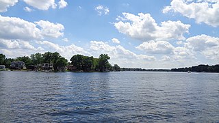
Cottrellville Township is a civil township of St. Clair County in the U.S. state of Michigan. The population was 3,559 at the 2010 Census.

<span class="mw-page-title-main">Kimball Township, Michigan</span> Civil township in Michigan, United States

Kimball Township is a civil township of St. Clair County in the U.S. state of Michigan. As of the 2010 census, the township population was 9,358.

<span class="mw-page-title-main">Wales Township, Michigan</span> Civil township in Michigan, United States

Wales Township is a civil township of St. Clair County in the U.S. state of Michigan. The population was 3,248 at the 2010 Census.

<span class="mw-page-title-main">Ira Township, Michigan</span> Civil township in Michigan, United States

Ira Township is a civil township of St. Clair County in the U.S. state of Michigan. The population was 5,178 at the 2010 Census.

<span class="mw-page-title-main">Washington Township, Macomb County, Michigan</span> Charter township in Michigan, United States

Washington Charter Township, located within Metro Detroit, is a charter township of Macomb County in the U.S. state of Michigan. The population was 28,165 at the 2020 census, up from 25,139 in 2010.

References

Notes

  1. 1 2 "2022 U.S. Gazetteer Files: Michigan". United States Census Bureau. Retrieved July 25, 2023.
  2. 1 2 "P1. Race – Chesterfield township, Macomb County, Michigan: 2020 DEC Redistricting Data (PL 94-171)". U.S. Census Bureau. Retrieved July 25, 2023.
  3. 1 2 "U.S. Census website". United States Census Bureau . Retrieved 2008-01-31.
  4. "Township of Chesterfield". Geographic Names Information System . United States Geological Survey, United States Department of the Interior.
  5. 1 2 Leeson, Michael A. (comp.) (2005) [1882]. "Chesterfield Township". History of Macomb County, Michigan. Ann Arbor, Mich.: University of Michigan Library. pp. 900 ff. Retrieved 2006-12-17.
  6. "Chesterfield Township, Michigan". Chesterfield Township, Michigan. Retrieved August 25, 2012.
  7. Romig 1986, p. 114.
  8. "Anchor Bay Gardens, Michigan". Geographic Names Information System . United States Geological Survey, United States Department of the Interior. & GNIS in Google Map
  9. "Anchor Bay Harbor, Michigan". Geographic Names Information System . United States Geological Survey, United States Department of the Interior. & GNIS in Google Map
  10. "Anchor Bay Shores, Michigan". Geographic Names Information System . United States Geological Survey, United States Department of the Interior. & GNIS in Google Map
  11. "Chesterfield, Michigan". Geographic Names Information System . United States Geological Survey, United States Department of the Interior. & GNIS in Google Map
  12. "Chesterfield Shores, Michigan". Geographic Names Information System . United States Geological Survey, United States Department of the Interior. & GNIS in Google Map
  13. Romig 1986, p. 189.
  14. "Lottivue, Michigan". Geographic Names Information System . United States Geological Survey, United States Department of the Interior. & GNIS in Google Map
  15. "Milton, Michigan". Geographic Names Information System . United States Geological Survey, United States Department of the Interior.
  16. Romig 1986, pp. 114, 189.
  17. Local History Tales Archive Archived 2007-01-13 at the Wayback Machine , Macomb County Historical Commission, Alan Naldrett
  18. "Point Lakeview, Michigan". Geographic Names Information System . United States Geological Survey, United States Department of the Interior. & GNIS in Google Map
  19. "Sebille Manor, Michigan". Geographic Names Information System . United States Geological Survey, United States Department of the Interior. & GNIS in Google Map
  20. 2010 census data for Chesterfield Township
  21. "Chesterfield Township names new public safety director". The Voice. 2022-01-14. Retrieved 2022-05-02.
  22. "Fire and EMS | Chesterfield County, VA". www.chesterfield.gov. Retrieved 2022-05-02.
  23. "Contact Us". Chesterfield Fire Department. Retrieved 2022-05-02.
  24. "Anchor Bay School District". Anchor Bay School District. Archived from the original on July 29, 2012. Retrieved August 24, 2012.
  25. "L'Anse Creuse Public Schools". L’Anse Creuse Public Schools. Retrieved August 24, 2012.

Sources