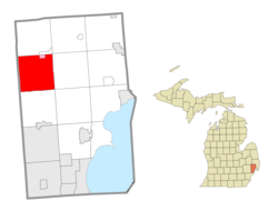
Charter Township of Washington | |
---|---|
Coordinates: 42°45′00″N83°01′56″W / 42.75000°N 83.03222°W | |
Country | United States |
State | Michigan |
County | Macomb |
Government | |
• Type | Council |
• Supervisor | Sebastian "Sam" Previti |
Area | |
• Total | 36.9 sq mi (96 km2) |
• Land | 35.6 sq mi (92 km2) |
• Water | 1.3 sq mi (3 km2) |
Elevation | 781 ft (238 m) |
Population | |
• Total | 28,165 |
• Density | 791.7/sq mi (305.7/km2) |
Time zone | UTC-5 (Eastern (EST)) |
• Summer (DST) | UTC-4 (EDT) |
ZIP Codes | 48065, 48094, 48095, 48306 |
Area code(s) | 248 and 586 |
FIPS code | 26-84120 [3] |
GNIS feature ID | 1627216 [4] |
Website | www |
Washington Charter Township, located within Metro Detroit, is a charter township of Macomb County in the U.S. state of Michigan. The population was 28,165 at the 2020 census, [2] up from 25,139 in 2010.
Washington Township was organized in 1827. [5] It is home to the historic Octagon House, built by Loren Andrus from 1858 to 1860. [6]
Westview Orchards was founded in what is now Washington Township in 1813. [7] The Mount Vernon Cemetery, located at the southeast corner of Mt. Vernon Road and 28 Mile Road, is evidence of a former settlement, named for George Washington’s estate. The village of Mount Vernon once had a post office with William Austin Burt as its first postmaster in 1832. [8]
Washington Township is in northwestern Macomb County and is bordered to the west by Oakland County. The village of Romeo is partially in the northeast part of the township. Ray Township is to the east, Shelby Township is to the south, and Bruce Township is to the north. Washington Township is 28 to 34 miles (45 to 55 km) north of downtown Detroit.
According to the United States Census Bureau, the township has a total area of 36.9 square miles (96 km2), of which 35.6 square miles (92 km2) are land and 1.3 square miles (3.4 km2), or 3.46%, are water. [1]
Weather in Washington Township (an outer suburb of Detroit) is similar to Detroit, generally being only a few degrees cooler allowing for more snow in the winter.
A notable weather event occurred on July 2, 1997, when during the Michigan Tornado Outbreak an F0 tornado touched down at 26 Mile Road and destroyed parts of the East Village Estates trailer park community. Six people were injured during the events. [12]
As of the census [3] of 2010, there were 25,139 people (up from 19,080 in 2000), 9,258 households, and 7,160 families residing in the township. The population density was 699.2 inhabitants per square mile (270.0/km2). There were 9,258 occupied housing units and 612 vacant units. The racial makeup of the township was 94.8% White, 1.6% African American, 0.2% Native American, 1.0% Asian, 0.04% Pacific Islander, 1.0% from other races, and 1.3% from two or more races. Hispanic or Latino of any race were 3.9% of the population.
There were 9,258 households, out of which 32.9% had children under the age of 18 living with them, 64.9% were married couples living together, 8.9% had a female householder with no husband present, and 22.7% were non-families. 19.2% of all households were made up of individuals, and 7.6% had someone living alone who was 65 years of age or older. The average household size was 2.70 and the average family size was 3.11.
In the township the population was spread out, with 25.0% under the age of 18, 7.3% from 18 to 24, 23.3% from 25 to 44, 30.3% from 45 to 64, and 14.1% who were 65 years of age or older. The median age was 41 years. For every 100 females, there were 97.8 males. For every 100 females age 18 and over, there were 94.7 males.
The median income for a household in the township was $68,841 in 2000 and $83,348 in 2016; the median income for a family was $78,988 in 2000 and $94,057 in 2016. In 2000, males had a median income of $60,721 versus $31,213 for females. The per capita income for the township was $38,657. About 5.7% of families and 7.1% of the population were below the poverty line (up from 2.8% of families and 3.7% of all individuals in 2000), including 9.6% of those under age 18 (up from 5.0% in 2000) and 5.9% of those age 65 or over (up from 2.7% in 2000).
The township has a Supervisor-Board style government with an elected supervisor, clerk, treasurer and four trustees. The school districts serving the township residents are Romeo Community Schools, Utica Community Schools, and Rochester Schools from Oakland County. [13]
Macomb County is a county located in the eastern portion of the U.S. state of Michigan, bordering Lake St. Clair, and is part of northern Metro Detroit. As of the 2020 Census, the population was 881,217, making it the third-most populous county in the state. The county seat is Mt. Clemens. Macomb County is part of the Detroit-Warren-Dearborn, MI Metropolitan Statistical Area. The city of Detroit is located on the county's southern border. Macomb County contains 27 cities, townships and villages, including three of the top ten most-populous municipalities in Michigan as of the 2020 census: Warren (#3), Sterling Heights (#4) and Clinton Township (#8). Most of this population is concentrated south of Hall Road (M-59), one of the county's main thoroughfares.
Atlas Township is a civil township of Genesee County in the U.S. state of Michigan. As of the 2020 census, the township population was 8,352, up from 7,993 at the 2010 census.
Lapeer Township is a civil township of Lapeer County in the U.S. state of Michigan. The population was 4,956 at the 2020 Census. The name is an Americanization of the French La pierre, which means "flint" or "flint stone".
Bruce Township is a civil township of Macomb County in the U.S. state of Michigan. As of the 2020 census, the township population was 9,324. The largely rural township is home to the Ford Motor Company Proving Grounds, which sits on 6 square miles (16 km2) of land in the western-central part of the township.
Clinton Township is a charter township in Macomb County in the U.S. state of Michigan. A northern suburb of Detroit, Clinton Township is located about 22 miles (35 km) northeast of downtown Detroit. As of the 2020 census, the township had a population of 100,513, making it the most populous township in Michigan, and the state's 8th-most populous community overall.
Fraser is a city in Macomb County in the U.S. state of Michigan. A northern suburb of Detroit, Fraser is located roughly 15 miles (24.1 km) northeast of downtown Detroit. As of the 2020 census, the city had a population of 14,726.
Harrison Charter Township is a charter township of Macomb County in the U.S. state of Michigan. The population was 24,314 at the 2020 census.
Lake Township is a former civil township located in Macomb County in the U.S. state of Michigan. The small township consisted of 0.6 mi2 (1.7 km2) of the Macomb County portion of the village of Grosse Pointe Shores, which was part of Grosse Pointe Township and mostly located in Wayne County on the western shores of Lake Saint Clair. At the 2000 census, the township population was 80.
Lenox Township is a civil township of Macomb County in the U.S. state of Michigan. As of the 2020 census, the population was 12,119, up from 10,470 in 2010.
Macomb Township is a civil township of Macomb County in the U.S. state of Michigan. The population was 91,663 at the 2020 census, up from 79,580 in 2010. As of 2020 it was the most-populous civil township in the state and the third most-populous township overall after the charter townships of Clinton and Canton.
Mount Clemens is a city in the U.S. state of Michigan. The population was 15,697 at the 2020 census. It is the seat of government of Macomb County.
Ray Township is a civil township of Macomb County in the U.S. state of Michigan. As of the 2020 census, the township population was 3,780.
Roseville is a city in Macomb County in the U.S. state of Michigan. A northern suburb of Detroit, Roseville is located roughly 13 miles (20.9 km) northeast of downtown Detroit. As of the 2020 census, the city had a population of 47,710.
Shelby Charter Township, officially the Charter Township of Shelby, is a charter township located in Macomb County in the U.S. state of Michigan. The township is an affluent northern suburb of Detroit. As of the 2020 census, the population was 79,408, up from 73,804 in 2010. Shelby Charter Township is one of the fastest-growing communities in Metro Detroit.
Sterling Heights is a city in Macomb County in the U.S. state of Michigan. A northern suburb of Detroit, Sterling Heights is located roughly 18 miles (29.0 km) north of downtown Detroit. As of the 2020 census, the city had a population of 134,346, placing Sterling Heights as the second-largest suburb of Detroit, and the fourth-most populous city in Michigan.
Oxford Township, officially the Charter Township of Oxford, is a charter township in Oakland County in the U.S. state of Michigan. The population was 22,419 at the 2020 census.
Springfield Charter Township is a charter township of Oakland County in the U.S. state of Michigan. As of the 2020 census, the township population was 14,703. The township was named for the numerous springs in the area.
Vernon Township is a civil township of Shiawassee County in the U.S. state of Michigan. The population was 4,273 at the 2020 census. The village of Vernon is located within the township. The township also surrounds the city of Durand, but the two are administered autonomously.
Canton Township is a charter township in Wayne County in the U.S. state of Michigan. A western suburb of Detroit, Canton is located roughly 23 miles (37.0 km) west of downtown Detroit, and 15 miles (24.1 km) east of Ann Arbor. As of the 2020 census, the township had a population of 98,659, making it Michigan's second most-populated township and ninth most-populated municipality overall.
Richmond Township is a civil township of Macomb County, Michigan, United States. At the 2020 census, the township population was 3,544, Which makes Richmond Township the least populated township in Macomb County. A portion of the city of Richmond is adjacent to the township, but is administratively autonomous.