Southeast Michigan

Last updated

Southeast Michigan
Michigan Regions.png
Metro Detroit lies within southeast Michigan.
Country Flag of the United States.svg United States
State Flag of Michigan.svg Michigan
Financial District in downtown Detroit DavidStottsitsamongDetroittowers.jpg
Financial District in downtown Detroit

Southeast Michigan, also called southeastern Michigan, is a region in the Lower Peninsula of Michigan that is home to a majority of the state's businesses and industries as well as slightly over half of the state's population, most of whom are concentrated in Metro Detroit.

Contents

Geography

It is bordered in the northeast by Lake St. Clair, to the south-east Lake Erie, and the Detroit River which connects these two lakes.

Principal cities

Other important cities within the core counties of Oakland, Macomb, and Wayne

Outlying cities

Some cities are considered within southeast Michigan, while also being a part of another region or metropolitan area. The following cities tend to identify themselves separately from southeast Michigan and are isolated from the core counties of Oakland, Macomb, and Wayne.

Metropolitan area

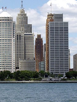
With 4,488,335 people in 2010, Metro Detroit was the tenth-largest metropolitan area in the United States, while Ann Arbor's metropolitan area ranked 141st with 341,847. Metropolitan areas of southeast Michigan, and parts of the Thumb and Flint/Tri-Cities, are grouped together by the U.S. Census Bureau with Detroit-Warren-Livonia MSA in a wider nine-county region designated the Detroit–Ann Arbor–Flint Combined Statistical Area (CSA) with a population of 5,428,000.

Combined Statistical Area

Southfield Town Center Southfield Town Center2.jpg

*Denotes member counties of the Southeast Michigan Council of Governments (SEMCOG)

Economy

The Renaissance Center, General Motors world headquarters WindsorPoliceboat.jpg
The Renaissance Center, General Motors world headquarters
Ann Arbor, home to the University of Michigan's main campus Ann Arbor Skyline 2021.jpg
Ann Arbor, home to the University of Michigan's main campus

The main economic activity is manufacturing cars. Major manufacturing cities are Warren, Sterling Heights, Dearborn (Henry Ford's childhood home) and Detroit, also called "Motor City" or "Motown". Other economic activities include banking and other service industries. Most people in Livingston, Macomb, Monroe, Oakland, Washtenaw, and Wayne Counties live in urban areas. In the recent years, urban sprawl has affected the areas of Canton, Commerce, Chesterfield, and Clinton townships. The metropolitan area is also home to some of the highest ranked hospitals and medical centers, Such as the Detroit Medical Center(DMC), Henry Ford Hospital, Beaumont Hospital, and the University of Michigan hospital in Ann Arbor.

SEMCOG Commuter Rail is a proposed regional rail link between Ann Arbor and Detroit.

The Detroit Metro Airport is the busiest in the area with the opening of the McNamara terminal and the now completed North Terminal. The airport is located in Romulus.

Manufacturing and service industries have replaced agriculture for the most part. In rural areas of Saint Clair County, Monroe, and Livingston Counties still grow crops such as corn, sugar beets, soy beans, other types of beans, and fruits. Romeo and northern Macomb County is well known for its apple and peach orchards.

Media

Radio

Most major Detroit radio stations, such as WJR and WWJ, can be heard in most or all of southeastern Michigan. Port Huron, Howell, Ann Arbor/Ypsilanti, Adrian, and Monroe are also served by their own locally-originating stations. National Public Radio is broadcast locally from Ann Arbor on Michigan Radio WUOM 91.7 FM and from Detroit on WDET-FM 101.9 FM.

Television

Major television stations include: WJBK Fox 2 Detroit (Fox), WXYZ Channel 7 (ABC), WDIV Local 4 (NBC), WWJ-TV CBS 62 (CBS) and WKBD CW 50 (CW).

Newspaper

Daily editions of the Detroit Free Press and The Detroit News are available throughout the area.

See also

Further reading

Related Research Articles

<span class="mw-page-title-main">Washtenaw County, Michigan</span> County in Michigan, United States

Washtenaw County is a county located in the U.S. state of Michigan. At the 2020 census, the population was 372,258. The county seat and largest city is Ann Arbor. The county was authorized by legislation in 1822 and organized as a county in 1826. Washtenaw County comprises the Ann Arbor Metropolitan Statistical Area. The county is home to the University of Michigan, Eastern Michigan University, Washtenaw Community College, and Concordia University Ann Arbor.

<span class="mw-page-title-main">Macomb County, Michigan</span> County in Michigan, United States

Macomb County is a county located in the eastern portion of the U.S. state of Michigan, bordering Lake St. Clair, and is part of northern Metro Detroit. As of the 2020 Census, the population was 881,217, making it the third-most populous county in the state. The county seat is Mt. Clemens. Macomb County is part of the Detroit-Warren-Dearborn, MI Metropolitan Statistical Area. The city of Detroit is located south of the county's southern border. Macomb County contains 27 cities, townships and villages, including three of the top ten most-populous municipalities in Michigan as of the 2010 census: Warren (#3), Sterling Heights (#4) and Clinton Township (#10). Most of this population is concentrated south of Hall Road (M-59), one of the county's main thoroughfares.

<span class="mw-page-title-main">Metro Detroit</span> Metropolitan area in Michigan, United States

Metro Detroit is a major metropolitan area in the U.S. state of Michigan, consisting of the city of Detroit and over 200 municipalities in the surrounding area with its largest employer being Oakland County. There are varied definitions of the area, including the official statistical areas designated by the Office of Management and Budget, a federal agency of the United States.

<span class="mw-page-title-main">Huron River</span> River in Michigan, United States

The Huron River is a 130-mile-long (210 km) river in southeastern Michigan, rising out of the Huron Swamp in Springfield Township in northern Oakland County and flowing into Lake Erie, as it forms the boundary between present-day Wayne and Monroe counties. Thirteen parks, game areas, and recreation areas are associated with the river, which passes through the cities of Dexter, Ann Arbor, Ypsilanti, Belleville, Flat Rock and Rockwood that were developed along its banks.

<span class="mw-page-title-main">United States District Court for the Eastern District of Michigan</span> United States federal district court in Michigan

The United States District Court for the Eastern District of Michigan is the federal district court with jurisdiction over of the eastern half of the Lower Peninsula of the State of Michigan. The Court is based in Detroit, with courthouses also located in Ann Arbor, Bay City, Flint, and Port Huron. The United States Court of Appeals for the Sixth Circuit has appellate jurisdiction over the court.

<span class="mw-page-title-main">Episcopal Diocese of Michigan</span> Diocese of the Episcopal Church in the United States

The Episcopal Diocese of Michigan is the Episcopal diocese comprising more than 70 congregations in the southeast part of Michigan.

<span class="mw-page-title-main">Area code 810</span> Telephone area code in east-central Michigan

Area code 810 is a telephone area code in the North American Numbering Plan for the east-central part in the U.S. state of Michigan. The numbering plan area (NPA) comprises the cities of Flint, Lapeer, Port Huron, and the southern portion of the Thumb.

<span class="mw-page-title-main">Detroit–Windsor</span> Transborder agglomeration

The Detroit–Windsor region is an international transborder agglomeration comprising the American city of Detroit, Michigan, the Canadian city of Windsor, Ontario, and the Detroit River between them. The Detroit–Windsor area acts as a critical commercial link straddling the Canada–United States border and has a total population of 5,976,595. It is North America's largest cross-border conurbation.

Michigan's 7th congressional district is a United States congressional district in Southern Michigan and portions of Central Michigan. From 2004 to 2013 it consisted of all of Branch, Eaton, Hillsdale, Jackson, and Lenawee counties, and included most of Calhoun and a large portion of western and northern Washtenaw counties. The current district, which was created in 2022, is centered around Lansing, Michigan's state capital, and includes all of Clinton, Shiawassee, Ingham, and Livingston counties, as well as portions of Eaton and Oakland counties.

Benjamin Franklin Hawkins Witherell was a jurist in the U.S. state of Michigan. He served as a justice of the Michigan Supreme Court in 1857.

<span class="mw-page-title-main">Roads and freeways in metropolitan Detroit</span> List of roads in part of Michigan

The Detroit metropolitan area in southeast Michigan is served by a comprehensive network of roads and highways. Three primary Interstate Highways pass through the region, along with three auxiliary Interstates, and multiple state and U.S. Highways. These are supplemented by the Mile Road System, a series of local roads spaced one mile apart on a perpendicular grid.

<span class="mw-page-title-main">2008 United States presidential election in Michigan</span> Election in Michigan

The 2008 United States presidential election in Michigan took place on November 4, 2008. It was part of the 2008 United States presidential election which happened throughout all 50 states and D.C. Voters chose 17 representatives, or electors to the Electoral College, who voted for president and vice president.

<span class="mw-page-title-main">Transportation in metropolitan Detroit</span>

Transportation in metropolitan Detroit comprises an expansive system of roads and freeways, multiple public transit systems, a major international airport, freight railroads, and ports. Located on the Detroit River along the Great Lakes Waterway, Detroit is a significant city in international trade, with two land crossings to Canada. Three primary Interstate highways serve the region.

A wind chill watch is issued by the National Weather Service of the United States when the wind chill could reach dangerous levels within the next 12 to 48 hours. The exact definition required to issue a watch varies from state to state or from National Weather Service county warning areas to another, but if forecasters believe conditions are favorable for life-threatening wind chills meeting local criteria, a watch will be issued. People going outside should plan to protect themselves against hypothermia and frostbite.

MotorCities National Heritage Area or Motor Cities National Heritage Area is a federally designated National Heritage Area that commemorates and promotes the automobile industry in Metro Detroit, with portions of 16 counties in southern Michigan, United States.

Saint Joseph Mercy Health System (SJMHS) one of the largest health care networks based in southeast Michigan, United States is now known as Trinity Health Michigan. It consist of five prime hospitals, nine Urgent Care Centers, and five Health Centers spread around metro Detroit, providing health care in six counties that include Livingston, Macomb, Oakland, St. Clair, Washtenaw, and Wayne.

The Regional Transit Authority of Southeast Michigan (RTA) is the agency with oversight and service coordination responsibility for mass transit operations in metropolitan Detroit, Michigan. The counties of Macomb, Oakland, Washtenaw, and Wayne are included in the agency's jurisdiction.

As of the census of 2010, there were 5,196,250 people, 1,682,111 households, and 1,110,454 families residing within the Detroit–Warren–Ann Arbor Combined Statistical Area. Within the Detroit–Warren–Dearborn Metropolitan Statistical Area, there were 4,296,250 people residing. The census reported 70.1% White, 22.8% African-American, 0.3% Native American, 3.3% Asian, 0.02% Pacific Islander, 1.2% from other races, and 2.2% from two or more races. Hispanic or Latino of any race were 6.2% of the population. Arab Americans were at least 4.7% of the region's population.

<span class="mw-page-title-main">SEMTA Commuter Rail</span>

SEMTA Commuter Rail, also known as the Silver Streak, was a commuter train operated by the Southeastern Michigan Transportation Authority (SEMTA) and the Grand Trunk Western Railroad between Detroit and Pontiac, Michigan. It began in 1974 when SEMTA assumed control of the Grand Trunk's existing commuter trains over the route. SEMTA discontinued operations in 1983. Amtrak began offering intercity service between Detroit and Pontiac in 1994 as part of its Michigan Services.