Romulus, Michigan

Last updated
Romulus, Michigan
City of Romulus
Romulus-MI-01s.jpg
Detroit Metropolitan Wayne County Airport DTW.jpg
Top: Downtown Romulus, loooking west from Goddard Road and Hunt Street; bottom: Detroit Metropolitan Wayne County Airport.
Romulusmi cityseal.jpg
Nickname: 
"Rom-town"
Motto: 
"Home of Opportunity"
Location of Romulus, Michigan in Wayne County.svg
Location within Wayne County
USA Michigan location map.svg
Red pog.svg
Romulus
Location within the state of Michigan
Usa edcp location map.svg
Red pog.svg
Romulus
Location within the United States
Coordinates: 42°13′20″N83°23′48″W / 42.22222°N 83.39667°W / 42.22222; -83.39667
Country Flag of the United States.svg United States
State Flag of Michigan.svg  Michigan
County Wayne
Settled1826
Organized1835 (Romulus Township)
Incorporated1970
Government
  Type Mayor–council
   Mayor Robert A. McCraight
   Clerk Ellen Craig-Bragg
Area
[1]
   City 35.95 sq mi (93.12 km2)
  Land35.61 sq mi (92.22 km2)
  Water0.34 sq mi (0.89 km2)
Elevation
659 ft (201 m)
Population
 (2020)
   City 25,178
  Density707.09/sq mi (273.01/km2)
   Metro
4,285,832 (Metro Detroit)
Time zone UTC-5 (Eastern (EST))
  Summer (DST) UTC-4 (EDT)
ZIP code(s)
48174, 48184
48242 (Detroit) [lower-alpha 1]
Area code 734
FIPS code 26-69420
GNIS feature ID0636147 [2]
Website romulusgov.com

Romulus is a city in Wayne County in the U.S. state of Michigan. The population was 23,989 at the 2010 census. [3] Romulus is a western suburb of Metro Detroit and is also considered part of the Downriver collection of communities. It is most notable as the location of the Detroit Metropolitan Airport, a major hub for Delta Air Lines.

Contents

History

The first white settler in Romulus was Samuel Polyne, a French-Canadian, who settled on section 2 in 1826, though he left soon after the township was organized in 1835.

The first settler in the village proper (prior to the 1865 annexation of the whole village and township into one city) was Samuel McMath, who moved from New York state to the area in 1827. He improved land and planned to bring his family to settle there, but he died before he could carry out this plan. [4]

Solomon Whitaker, Charles and Joseph Pulcifer located in the area in 1830, and in 1833, Jenks Pullen and his six sons settled at what became known as "Pullen's Corners" (located in section 19 at the intersection of Ozga and Goddard roads, now commonly called "Five Points"). Pullen's Corners was platted in 1836. The community later took on the name of the township. [5] [6] [7] [8]

The township of Romulus was set off from a part of Huron Township by an act of the Michigan Territorial Council on March 17, 1835, and the first township meeting was held on April 16, 1835, two years before the State of Michigan was admitted in to the Union (1837), in the house of Joseph T. Pullen. The first supervisor was David J. Pullen. The township's name was changed to "Wayne" on March 19, 1845, but was changed back to Romulus on January 16, 1848. [5] [6] [7] [8]

Romulus incorporated as a city in 1970. [9]

Village of Romulus

The village of Romulus was platted on the Lansing B. Misner estate in 1871. [10]

Underground Railroad stops

Romulus was a stop of the Underground Railroad in the 1800s when slaves fled the inhumane conditions of plantations in the South for the free states of the North. There were two stops in Romulus and those structures are still intact to this day.

Preston

Preston was located in the north-east part of Romulus. It had a post office from 1899 to 1906. [11]

Airliner incidents

On August 16, 1987, Detroit Metro Airport in Romulus was the site of the Northwest Airlines Flight 255 disaster, in which the plane crashed into an overpass bridge and exploded just seconds after taking off. The crash killed all but one of the 155 passengers and crew and two more people on the roadway. [12] A memorial for the victims is at the crash site at the Interstate 94 and Middlebelt Road interchange.

On December 25, 2009, another Northwest plane, Flight 253, suffered an unsuccessful bombing attempt as it approached Metro Airport. Nigerian man Umar Farouk Abdulmutallab from Al-Qaeda in the Arabian Peninsula was convicted of eight criminal counts and sentenced to four life sentences plus 50 years without parole. [13]

Chemical plant explosion

On August 9, 2005, at approximately 9:30 PM, the EQ Recovery Plant caught fire. Citizens within 1 to 1+1/3 miles (1.6 to 2.1 km) radius were forced to evacuate their homes. Romulus and Wayne fire crews and crews from neighboring communities managed to put out the fire after letting it burn down a little bit. Chemical-filled smoke filled the sky, causing respiratory problems. Many citizens from both Romulus and Wayne were taken to Oakwood Annapolis Hospital (now Beaumont Hospital-Wayne), about two miles from the explosion site. No one was injured. [14]
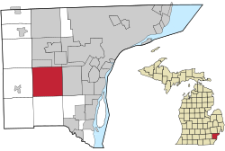
Geography

According to the United States Census Bureau, the city has a total area of 35.95 square miles (93.11 km2), of which 35.61 square miles (92.23 km2) is land and 0.35 square miles (0.91 km2) (0.95%) is water. [3]

Romulus is in the south-central portion of Wayne County. Interstate 94 (I-94) and I-275 run through the city. [15]

The City of Romulus is bordered to the north by Van Born Road, to the south by Pennsylvania Road, to the east by Inkster Road, and to the west by Hannan Road.

Demographics

Historical population
CensusPop.Note
1970 22,900
1980 24,8578.5%
1990 22,897−7.9%
2000 22,9790.4%
2010 23,9894.4%
2020 25,1785.0%
U.S. Decennial Census
2018 Estimate [16]

2010 census

As of the census [17] of 2010, there were 23,989 people, 8,975 households, and 6,135 families living in the city. The population density was 673.7 inhabitants per square mile (260.1/km2). There were 9,946 housing units at an average density of 279.3 per square mile (107.8/km2). The racial makeup of the city was 50.5% White, 43% African American, 0.5% Native American, 1.1% Asian, 0.1% Pacific Islander, 0.9% from other races, and 3.9% from two or more races. Hispanic or Latino of any race were 3.0% of the population.

There were 8,975 households, of which 37.8% had children under the age of 18 living with them, 40.7% were married couples living together, 21.1% had a female householder with no husband present, 6.6% had a male householder with no wife present, and 31.6% were non-families. 26.0% of all households were made up of individuals, and 8.2% had someone living alone who was 65 years of age or older. The average household size was 2.64 and the average family size was 3.16.

The median age in the city was 36.2 years. 26.8% of residents were under the age of 18; 9.2% were between the ages of 18 and 24; 27.4% were from 25 to 44; 27% were from 45 to 64; and 9.8% were 65 years of age or older. The populace was 48.4% male and 51.6% female.

2000 census

As of the census of 2000, there were 22,979 people, 8,439 households, and 5,941 families living in the city. The population density was 639.9 inhabitants per square mile (247.1/km2). There were 8,943 housing units at an average density of 249.0 per square mile (96.1/km2). The racial makeup of the city was 65.36% White, 29.99% African American, 0.54% Native American, 0.59% Asian, 0.09% Pacific Islander, 0.81% from other races, and 2.63% from two or more races. Hispanic or Latino of any race were 2.01% of the population.

There were 8,439 households, out of which 36.7% had children under the age of 18 living with them, 46.5% were married couples living together, 18.5% had a female householder with no husband present, and 29.6% were non-families. 23.8% of all households were made up of individuals, and 7.2% had someone living alone who was 65 years of age or older. The average household size was 2.70 and the average family size was 3.19.

In the cities population consists of 29.2% under the age of 18, 8.4% from 18 to 24, 31.7% from 25 to 44, 22.8% from 45 to 64, and 7.9% who were 65 years of age or older. The median age was 33 years. For every 100 females, there were 95.1 males. For every 100 females age 18 and over, there were 92.6 males.

The median income for a household in the city was $45,088, and the median income for a family was $51,497. Males had a median income of $41,372 versus $27,517 for females. The per capita income for the city was $19,679. About 10.6% of families and 12.6% of the population were below the poverty line, including 16.8% of those under age 18 and 12.4% of those age 65 or over.

Government and infrastructure

City government

The elected city officials for the City of Romulus as of November 2021 (all terms end in 2025):

Official PositionName of Official
MayorRobert A. McCraight
City ClerkEllen Craig-Bragg
City TreasurerStacy Paige
City CouncilJohn Barden (Mayor Pro-Tem)
Virginia Williams
Tina M. Talley
William J. Wadsworth Jr.
Celeste Roscoe
Kathleen Abdo
Eva Webb

Wayne County Airport Authority

The Wayne County Airport Authority has its headquarters in the former L.C. Smith Terminal at Detroit Metro Airport in Romulus. It also has an operational police department, which its headquarters is located in the 610 building of the airport on the East service Drive, near the L.C. Smith building. [18]

Infrastructure

The United States Postal Service operates the Romulus-Carl W. Morris Post Office located in downtown on Hunt Street and Goddard Road. [19]

In 1975, General Motors, opened the Romulus Engine plant on Ecorse Road. The facility produces V6 engines and 10-speed automatic transmissions for a plethora of Chevrolet, Buick, GMC, and Cadillac vehicles. [20]

In 2018, major online retailer Amazon opened its DTW1 Fulfillment Center, north of Metro Airport near Ecorse and Vining Roads. Approximately 1,600 workers are employed at the site. [21] Grocery retailer Kroger built a $95 million automated fulfillment center to accommodate fast-paced online grocery shopping on the city's south side, near I-275 and Eureka Road, in 2021. [22]

Romulus has a variety of small businesses throughout the city including hotels, bars, and restaurants. Retail is scarce in the city with the exception of a few pharmacies and small discount retailers. Due to the lack of major grocery retailers and numerous failed attempts to bring in new stores to the food desert community, most citizens have to travel to adjacent cities including Van Buren Township and Taylor to go to more prominent supermarket chains.

Parks and recreation

After a failed city millage in February 2011, city officials had to close all of the city parks in order to keep the city financially stable. However, the Downtown Development Authority were willing to maintain the operations of Mary Ann Banks Park & Historical Park, reopening the park in Spring 2011. By 2015, the city's finances had rebounded and with determination from city officials and citizens, most of the city's parks have reopened with improvements and even opening a new park - including:

The Romulus Athletic Center, located at 35765 Northline Road, is a facility for recreation and conferences. It opened on April 1, 2008.

Economy

Education

Romulus Community School District administration building Romulus Community Schools Administrative offices.jpg
Romulus Community School District administration building
Romulus Senior High School, 2011. The school has since been renovated. Romulus Senior High School Michigan.jpg
Romulus Senior High School, 2011. The school has since been renovated.

The Romulus Community School District serves and educates the children in the City of Romulus and other communities. The district is made up of a high school (Romulus Senior High School), a middle school, an early childhood center, and four elementary schools - Barth, Halecreek, Romulus, and Wick.

A portion is instead within the Wayne-Westland Community Schools. [23] It is zoned to Roosevelt-McGrath Elementary School in Wayne, [24] Franklin Middle School in Wayne, [25] and Wayne Memorial High School in Wayne. [26]

Summit Academy Schools and Metro Charter Academy are charter schools that serves students in the Brownstown and Romulus areas respectfully.

The Roman Catholic Archdiocese of Detroit formerly operated the St. Aloysius School in Romulus. [27]

Notable people

Notes

  1. The Detroit 48242 ZIP Code is used exclusively for the Detroit Metropolitan Airport, which is a county-owned airport located in Romulus.

Related Research Articles

<span class="mw-page-title-main">Wayne County, Michigan</span> County in Michigan, United States

Wayne County is the most populous county in the U.S. state of Michigan. As of 2020, the United States Census placed its population at 1,793,561, making it the 19th-most populous county in the United States. The county seat is Detroit. The county was founded in 1796 and organized in 1815. Wayne County is included in the Detroit-Warren-Dearborn, MI Metropolitan Statistical Area. It is one of several U.S. counties named after Revolutionary War-era general Anthony Wayne.

<span class="mw-page-title-main">Mayfield Township, Grand Traverse County, Michigan</span> Civil township in Michigan, United States

Mayfield Township is a civil township of Grand Traverse County in the U.S. state of Michigan. The population was 1,786 at the 2020 census, an increase from 1,550 at the 2010 census.

<span class="mw-page-title-main">Courtland Township, Michigan</span> Township in Michigan, United States

Courtland Township is a civil township of Kent County in the U.S. state of Michigan. The population was 7,678 at the 2010 census, which was an increase from 5,817 at the 2000 census.

<span class="mw-page-title-main">Shelby Charter Township, Michigan</span> Charter township in Michigan, United States

Shelby Charter Township, officially the Charter Township of Shelby, is a charter township located in Macomb County in the U.S. state of Michigan. The township is an affluent northern suburb of Detroit. As of the 2020 census, the population was 79,408, up from 73,804 in 2010. Shelby Charter Township is one of the fastest-growing communities in Metro Detroit.

<span class="mw-page-title-main">Ash Township, Michigan</span> Civil township in Michigan, United States

Ash Township is a civil township of Monroe County in the U.S. state of Michigan. As of the 2020 census, the township population was 7,860.

<span class="mw-page-title-main">Berlin Charter Township, Michigan</span> Charter township in Michigan, United States

Berlin Charter Township is a charter township of Monroe County in the U.S. state of Michigan. At the 2020 census, the township population was 9,890.

<span class="mw-page-title-main">Erie Township, Michigan</span> Civil township in Michigan, United States

Erie Township is a civil township of Monroe County in the U.S. state of Michigan. The population was 4,299 at the 2020 census. Sharing a southern border with the city of Toledo, Ohio, about 45 miles (72 km) southwest of the city of Detroit, the township is one of the southernmost areas included in the Detroit–Warren–Ann Arbor Combined Statistical Area.

<span class="mw-page-title-main">Frenchtown Charter Township, Michigan</span> Charter township in Michigan, United States

Frenchtown Charter Township is a charter township within Monroe County in the U.S. state of Michigan. The population was 21,609 as per the 2020 census.

<span class="mw-page-title-main">Commerce Township, Michigan</span> Charter township in Michigan, United States

Commerce Township, officially the Charter Township of Commerce, is a charter township of Oakland County in the U.S. state of Michigan. The population was 40,186 at the 2010 census.

<span class="mw-page-title-main">Ypsilanti Charter Township, Michigan</span> Charter township in Michigan, United States

Ypsilanti Charter Township is a charter township of Washtenaw County in the U.S. state of Michigan. The population was 53,362 at the 2010 census. The city of Ypsilanti is mostly surrounded by the township, but the two are administered autonomously.

<span class="mw-page-title-main">Canton, Michigan</span> American township in Michigan

Canton Township is a charter township in Wayne County in the U.S. state of Michigan. A western suburb of Detroit, Canton is located roughly 23 miles (37.0 km) west of downtown Detroit, and 15 miles (24.1 km) east of Ann Arbor. As of the 2020 census, the township had a population of 98,659, making it Michigan's second most-populated township and ninth most-populated municipality overall.

<span class="mw-page-title-main">Inkster, Michigan</span> City in Michigan, United States

Inkster is a city in Wayne County in the U.S. state of Michigan. A western suburb of Detroit, Inkster is located about 14 miles (23 km) southwest of downtown Detroit. As of the 2020 census, the city had a population of 26,088.

<span class="mw-page-title-main">Redford, Michigan</span> Township in Michigan, United States

Redford Township is a charter township in Wayne County in the U.S. state of Michigan. An inner-ring suburb of Detroit, Redford borders Detroit to the west, roughly 15 miles (24.1 km) northwest of downtown Detroit. As of the 2020 census, the township had a population of 49,504.

<span class="mw-page-title-main">Sumpter Township, Michigan</span> Civil township in Michigan, United States

Sumpter Township is a civil township of Wayne County in the U.S. state of Michigan. The population was 9,660 at the 2020 census.

<span class="mw-page-title-main">Taylor, Michigan</span> City in Michigan, United States

Taylor is a city in Wayne County in the U.S. state of Michigan. Its population was 63,409 at the 2020 census. Taylor is the fifth most-populated city in Wayne County and the 17th most-populated city in Michigan.

<span class="mw-page-title-main">Van Buren Township, Michigan</span> American township in Michigan

Van Buren Township is a charter township in Wayne County in the U.S. state of Michigan. A western suburb of Detroit, Van Buren Township is located roughly 28 miles (45.1 km) southwest of downtown Detroit, and 17 miles (27.4 km) southeast of Ann Arbor. As of the 2020 census, the township had a population of 30,375. It surrounds, but is independent of, the city of Belleville.

<span class="mw-page-title-main">Wayne, Michigan</span> City in Michigan, United States

Wayne is a city in Wayne County in the U.S. state of Michigan. A western suburb of Detroit, Wayne is located about 18 miles (29 km) southwest of downtown Detroit. As of the 2020 census, the city had a population of 17,713.

<span class="mw-page-title-main">Westland, Michigan</span> City in Michigan, United States

Westland is a city in Wayne County in the U.S. state of Michigan. A western suburb of Detroit, Westland is located about 18 miles (29 km) west of downtown Detroit. As of 2022, the city had a population of 84,037.

<span class="mw-page-title-main">Manchester Township, Michigan</span> Civil township in Michigan, United States

Manchester Township is a civil township of Washtenaw County in the U.S. state of Michigan. The population was 4,626 at the 2020 census, although the population is less now after the village of Manchester, which was within the boundaries of the township, incorporated as an autonomous city in 2023.

<span class="mw-page-title-main">Livonia, Michigan</span> City in Michigan, United States

Livonia is a city in Wayne County, Michigan, United States. A western suburb of Detroit, Livonia is located roughly 20 miles (32.2 km) northwest of downtown Detroit. As of the 2020 census, the city had a population of 95,535. Originally organized as Livonia Township in 1835, it incorporated as a city in 1950.

References

  1. "2020 U.S. Gazetteer Files". United States Census Bureau. Retrieved May 21, 2022.
  2. "US Board on Geographic Names". United States Geological Survey. October 25, 2007. Retrieved 2008-01-31.
  3. 1 2 "Michigan: 2010 Population and Housing Unit Counts 2010 Census of Population and Housing" (PDF). 2010 United States Census . United States Census Bureau. September 2012. p. 44 Michigan. Retrieved November 7, 2020.
  4. Romig, Walter. Michigan Place Names (Grosse Pointe: Walter Romig, n.d.) p. 483
  5. 1 2 Fuller, George Newman (2005) [1928?]. "County Organization and Government". Local history of Detroit and Wayne County / edited by George B. Catlin. Ann Arbor, Mich.: University of Michigan Library. pp. 109–110. Retrieved 2007-04-01.
  6. 1 2 Farmer, Silas (2005) [1890]. "Romulus Township". History of Detroit and Wayne County and early Michigan. Ann Arbor, Mich.: University of Michigan Library. pp. 1362–1364. Retrieved 2007-04-01.
  7. 1 2 Wayne County Historical and Pioneer Society. (2005) [1890]. "Romulus". In Frederick Carlisle (ed.). Chronography of notable events in the history of the Northwest Territory and Wayne County. Ann Arbor, Mich.: University of Michigan Library. p. 81. Retrieved 2007-04-01.
  8. 1 2 "Brief History of Romulus". City of Romulus. Archived from the original on 2006-10-31. Retrieved 2007-04-01.
  9. Romig. Michigan Place Names, p. 483
  10. Romig. Michigan PlaceNames. p. 484
  11. Romig. Michigan Place Names, p. 459
  12. ""Aircraft Accident Report, Northwest Airlines, Inc. McDonnell Douglas DC-9-82, N312RC, Detroit Metropolitan Wayne County Airport, Romulus, Michigan, August 16, 1987"" (PDF). national transportation safety board. Archived (PDF) from the original on 2016-04-09.
  13. "Underwear bomber sentencing: Umar Farouk Abdulmutallab gets life sentence - POLITICO". Politico .
  14. "'Toxic' Explosion Shakes Romulus". ClickOnDetroit. Archived from the original on 8 December 2010.
  15. "Romulus." (Archive) Wayne County, Michigan. June 9, 2003. Retrieved on November 2, 2013.
  16. "Population Estimates". United States Census Bureau . Retrieved June 8, 2018.
  17. "U.S. Census website". United States Census Bureau . Retrieved 2012-11-25.
  18. "Travel Tips & Security Information  :: Contact Us." Wayne County Airport Authority. Retrieved on December 11, 2010. "Wayne County Airport Authority Mailing Address Detroit Metropolitan Airport Smith Terminal - Mezzanine Level Detroit, MI 48242"
  19. "Post Office Location - ROMULUS." United States Postal Service. Retrieved on December 11, 2010.
  20. "https://plants.gm.com/media/us/en/gm/company_info/facilities/powertrain/romulus.html"
  21. "https://www.detroitnews.com/story/business/2019/06/06/amazon-robotics-fulfillment-center-romulus/1273173001/"
  22. "https://www.freep.com/story/news/local/michigan/wayne/2020/09/28/kroger-fulfillment-center-romulus-michigan/3562694001/"
  23. "Home." (Archive) Wayne-Westland Community Schools. Retrieved on November 12, 2012.
  24. "rooseveltm.pdf." (Archive) Wayne-Westland Community Schools. Retrieved on November 2, 2013.
  25. "franklin.pdf." (Archive) Wayne-Westland Community Schools. Retrieved on November 2, 2013.
  26. "waynemem.pdf." (Archive) Wayne-Westland Community Schools. Retrieved on November 2, 2013.
  27. "School Locator". Roman Catholic Archdiocese of Detroit. 2003-02-22. Archived from the original on 2003-02-23. Retrieved 2020-05-02.