The Midtown area is a general mixed-use community area of neighborhoods containing successive waves of development that have transformed the area multiple times since it was first platted. The neighborhoods are dominated by the thoroughfare of Woodward Avenue, which runs north and south through the heart of Midtown. This neighborhood was previously known as Cass Corridor and many Detroiters continue to refer to it as such.[2]
Woodward Avenue, running north and south through the center of the neighborhood, is primarily inhabited by commercial businesses, public-oriented/cultural institutions, and religious buildings. The heart of the cultural center (the Detroit Public Library Main Branch and the Detroit Institute of Arts) is located directly on Woodward in the northern part of Midtown.[3]
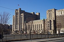
The north part of Midtown west of Woodward Avenue is dominated by Wayne State University, whose campus subsumes nearly the entire northwest portion of Midtown north of Warren Avenue and west of Woodward.[4] Wayne State University's campus covers 203 acres (0.82km2) in the northwestern section of Midtown.[5] Wayne's campus is irregular, and parts extend south of Warren (notably Old Main) and north of I-94, out of Midtown and into the New Center neighborhood. Additionally, Wayne's athletic facilities are west of the Lodge Freeway. Wayne is one of Michigan's three research institutions and serves over 32,000 students.[5]
The first portion of what later became Wayne State University was the Detroit Medical College, which was founded in 1868.[6] The school of education was begun in 1881.[7] In 1896, Old Main was built as Detroit's Central High School. College classes were added in 1913, and these Liberal Arts classes evolved into Detroit Junior College in 1917. The school began offering four-year degrees in 1923 and graduate courses were added in 1930. Three years later, the previously disparate colleges were united under one administration into Wayne University. In 1956, the school was renamed Wayne State University.[7]
Since the early 1940s, Wayne State University, backed by the City Planning Commission, has shaped the development of the surrounding area through its plan for growth. The availability of urban redevelopment grants beginning in the 1950s became an important funding resource for expansion of the university.[8] The size of the campus has continued to expand, with the University constructing new buildings as well as repurposing older buildings located in the area. As of fall 2015, nearly 30,000 students were enrolled at Wayne State: over 18,000 undergraduate students and over 8,000 graduate students, with the remainder enrolled in professional programs.[9]
The Art Center portion of Midtown also contains substantial residential areas, including the East Ferry Avenue Historic District and scattered late-19th century homes to the east of the Detroit Institute of Art. These neighborhoods have been infilled with townhomes and other residential developments and revitalizations.[10]
South of Wayne State University, the North Cass (or Cass Farm) area contains a substantial number of multi-unit apartment houses, many mixed with earlier single-family homes. This area has been heavily influenced by the expansion of Wayne State, with some of WSU's campus extending into the northern section of North Cass, and much of the residential housing stock taken up by Wayne students.
There are also a number of commercial buildings, particularly along the Cass Corridor just west of Woodward. Many of these support commercial businesses, and an independent retail study by the University Cultural Center Association has shown that the number of independent retail outlets in Midtown Detroit is increasing. The north Cass section also has a smattering of industrial buildings dating from the automotive heyday of Detroit. Many of these, such as the Willys Overland building,[10] have been or are being converted into residential loft space.
Harper Hospital was founded in 1863, receiving its first patients, Civil War soldiers, in 1864.[14] Two years later it opened as a general hospital. In 1882 a new hospital building was constructed on what is now the campus of the DMC. Additional buildings were constructed in 1913 and 1928.[14] Hutzel Women's Hospital, founded in 1868, was Detroit's second hospital.[15] Grace Hospital was founded in 1883,[16] and Children's Hospital was founded three years later.[17] Detroit Receiving was founded in 1915, and moved to its present location in 1980.[18]
In 2012, two major construction projects were begun in New Center, the Henry Ford Health System started the first phase of a $500million, 300-acre revitalization project, with the construction of a new $30million, 275,000-square-foot, Medical Distribution Center for Cardinal Health, Inc.[19][20] and Wayne State University started construction on a new $93million, 207,000-square-foot, Integrative Biosciences Center (IBio).[21][22] As many as 500 researchers and staff will work out of the IBio Center. [23]
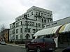
South of Martin Luther King Jr Boulevard, the area of Midtown around Cass Park is at a substantial distance from both the downtown core and the influence of Wayne State. The area around Cass Park proper is anchored by Cass Technical High School and the Detroit Masonic Temple, but the portion near Woodward Avenue and the once-fashionable Park Avenue district are awaiting redevelopment.
The Brush Park district proper runs from Mack Avenue to the Fisher freeway, and extends east and west from Woodward Avenue to Beaubien Street.[24][25]
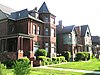
Brush Park was developed beginning in the 1850s as a residential neighborhood for Detroit's elite citizens.[26] Construction peaked in the 1870s and 1880s; one of the last homes built was constructed in 1906 by architect Albert Kahn for his personal use. Early residents of Brush Park included lumber baronDavid Whitney Jr., his daughter Grace Whitney Evans, Joseph L. Hudson, founder of the eponymous department store, lumber baron Lucien Moore, banker Frederick Butler, and dry goods manufacturer Ransom Gillis. During the 19th century, around 300 homes were built in Brush Park, including 70 Victorian mansions.[26] The neighborhood is currently experiencing restoration of its historic homes; at present, about 80 original structures remain in the area. Brush Park's revival began in the 1990s and has accelerated recently. A number of the older mansions have been restored, and more have been stabilized. In addition, new condominiums have been built in the southern part of Brush Park, near the Fisher Freeway.[27]
In the far southeastern corner of Midtown, to the east of Beaubien and Brush Park proper, the now-demolished Brewster-Douglass Housing Projects were located near the Chrysler Freeway. Midtown contains within its boundaries a number of historic districts and neighborhoods.[28][29][spamlink?]
Brush Park is the 22-block area bounded by Mack to the north, Woodward to the west, Beaubien to the east, and the Fisher Freeway to the south.[29] The Woodward East Historic District, located within the locally designated Brush Park neighborhood, is particularly known for the High Victorian style residences constructed for Detroit's wealthiest citizens. Although many of the once-grand houses have been demolished in recent years, those remaining exhibit a variety of Victorian style subtypes and architectural details.
The Cass Corridor is bounded by Woodward Ave. to the East, West Grand Blvd. to the North, the John C. Lodge Freeway to the West, and the Fisher Freeway serves as its southern terminus in Downtown Detroit.[29]
Originally home to some of Detroit's wealthiest residents from the late 19th to mid 20th century, it developed as the hub of urban arts and culture in Detroit. Wayne State University expanded in the area to encompass much of the original Cass Corridor. Little Caesars Arena, the new home of both the Detroit Red Wings and the Detroit Pistons, is in this area.
The Cass-Davenport Historic District includes four apartment buildings near the corner of Cass Avenue and Martin Luther King Boulevard. Two are typical of the small-scale, luxurious apartment buildings built in Detroit near the start of the 20th century and two are typical of the large-scale, high-density apartment buildings constructed between 1915 and 1930.
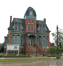
In the mid-1880s, D. M. Ferry platted his seed farm near Woodward into residential lots. East Ferry Avenue was quickly settled by prosperous middle and upper middle class Detroit residents. Although Woodward Avenue has since been redeveloped into primarily commercial property, the mansions and upscale housing on East Ferry survives. The district includes the separately-designated Col. Frank J. Hecker House and the Charles Lang Freer House.
The Midtown Woodward Historic District spans two blocks along Woodward Avenue, and contains three Alber Kahn-designed structures—the Addison Hotel, Kahn Print Shop, and the Temple Beth-El—in addition to the C. Howard Crane-designed Fine Arts Theatre.
This district contains a mix of building styles. Upper-class Detroit citizens built single-family homes in the area in 1880–1895. During the same time, apartment living became more popular, and duplexes and small apartment buildings were constructed in the 1890s through the first part of the 20th century. Commercial development was added to the mix in the years after World War I.
The West Canfield Historic district is located on a primarily residential block of Canfield. Homes in the district are examples of Queen Anne architecture that have remained nearly unchanged since the late 19th century. A boundary increase (added 1997-09-22) added buildings on Third Avenue between Canfield and Calumet to the district.
The Willis-Selden Historic District includes a large number of commercial buildings and high-density apartment buildings built in the early 1900s to service Detroit's booming auto economy.
The area that is now Midtown was first platted after the disastrous 1805 fire in Detroit, when the United States Congress authorized the platting of a new village at Detroit.[30] Land titles were granted to settle remaining uncertainty over the ownership of some parcels, which was in part due to the then fairly recent departure of British colonial forces.[30] During this platting, congress authorized the platting of land north of Detroit on both sides of the main thoroughfare, Woodward Avenue. These lots were known as the "Park Lots."
The section of Midtown to the west of the Park Lots is known as the "Cass Farm" area, after the name of one of the original ribbon farms that ran north from the river through the area. The original Cass Farm ran between what is now Cass Avenue and Third Avenue.[30] In 1816, Lewis Cass purchased the ribbon farm. The property was gradually developed over the years, with the sections closest to the river being developed first. By the time Cass died in 1866, a few of the blocks north of Martin Luther King Boulevard had just been platted. Cass's children continued to plat the area after his death.[30] Two more farms ran through Midtown west of Woodward: the Jones/Crane Farm, named for De Garmo Jones, onetime mayor of Detroit, which was located between what is now Third Avenue and the alley east of Fourth Street; and the Forsythe Farm, located between what is now Fourth Street and the Lodge Freeway.[30]
To the east of the Park Lots, the ribbon farm running through the midtown area was owned by John Askin, an Irish trader.[31] Askin's daughter Adelaide married Elijah Brush, the scion of the well-known Brush family of Detroit; the farm passed on to the couple and eventually their son Edmund.[31] Edmund Brush began subdividing the farm in the latter half of the 19th century.[31]
Despite the early date of the platting of the Park Lots, development of the area was slow at first, as early 19th century growth in Detroit occurred primarily east and west of Woodward, along Fort Street and Jefferson Avenue.[32] Even into the 1840s, only a handful of buildings, presumably farm structures, were located in the area.[30] The first east-west street in what is now Brush Park, in the southern section of Midtown, was not opened until 1852.[31]
It wasn't until during the Civil War, as the downtown district became more business-oriented, that northern Woodward Avenue began to be developed.[32] Construction turned the area that is now Midtown into a primarily upscale, quiet residential district, far from the hustle of the city center. Urban development of the area accelerated in 1870, when the population of Detroit was nearly 80,000. Streetcar lines established in the 1860s allowed residents to more conveniently travel from the Midtown area to downtown.[30]
1870–1910
The West Canfield Historic District, platted in 1871, was one of the first recorded subdivisions in the area.[30] The district features large and expensive lots, and many prominent Detroiters settled on the block. A severe depression slowed development, but it picked up again in the late 1870s.[30] The period from 1880 to 1895 brought a boom in the construction of elegant single-family and duplex homes in the Midtown area. The lots on Woodward were the most expensive and featured the most opulent homes; the lots immediately off the main street were soon filled with the homes of Detroit's upper class. School and religious buildings were also constructed in the area.[30]
As Detroit grew, the demand for apartment housing also grew; beginning in 1895, the construction in the Cass Farm area began to focus more on small apartment buildings.[30] This was particularly true in the last portion of the district to be developed, the section south of Warren between Cass and Third. Here a number of small-scale apartment buildings were constructed around the start of the 20th century.[30]
1910–1930
As the city continued to expand, the character of the neighborhood changed. Even before World War I, the congestion along Woodward precipitated a change from upper-class housing to commercial ventures.[30] The rise of the automobile made more distant neighborhoods such as Boston-Edison and Indian Village easily accessible from the center of Detroit, and families of means moved out of the stately houses along Woodward and in Brush Park.[31]
The construction of Orchestra Hall heralded a City Beautiful movement that turned much of the area into public-oriented space; the idea of turning Midtown into a cultural mecca continued with the construction of the library and the DIA in the 1920s.[30]
The rise of the automobile also changed the area. Midtown's proximity to the automotive plants in the Milwaukee Junction area made it ideal for housing auto workers. During the 1910s and 1920s, larger apartment buildings were constructed in the area, and many remaining single-family homes were converted into boardinghouses.[26][30] Commercial usage also increased in the area, particularly in automotive-related sectors: showrooms, service stations, and part supply businesses.[30]
1930–present
The Great Depression heralded a downturn for the Midtown area. Newly constructed buildings fell into foreclosure, and many of the formerly well-paid auto workers living in the area were out of work.[30] By the time the recovery from World War II stimulated the economy, industry had relocated to the suburbs, and the area gradually became more residential.[30]
During the Great Depression, many of the older mansions were subdivided into apartments, and as demand for housing fell after World War II.
In the 1950s, demolition of out-moded houses and businesses began, a practice that extended into the 1980s. Wayne State University also began to have more influence in the area, rehabilitating old buildings and building new ones in the northwestern section of the neighborhood.[30] The current boundaries of Midtown were also delineated when the interstate freeways through Detroit were built, particularly the Chrysler Freeway (I-75) on the east, the Lodge Freeway (M-10) on the west, the Edsel Ford Freeway (I-94) on the north, and the Fisher Freeway (I-75) on the south. The Chrysler followed the course of Hastings Street, the center of African-American life in Detroit at the time. To house displaced residents, the Brewster-Douglass Housing Projects were built in the far east of the Midtown area, near the Chrysler and what once had been the thriving Hastings Street community.
As the focus shifted to revitalization in the 1990s, more structures in the area have been refurbished, by Wayne State, other public groups, and by private parties.[30]
In September 2005 the company Lovio George Inc., located at Forest and Third in Detroit, revealed a new logo for Midtown Detroit.[33]
In 2011, Midtown's apartment buildings were 94% occupied.[34]
Economy
Midtown Detroit is home the Detroit Medical Center, the largest private employer in the city of Detroit with more than 12,000 employees.[35] The DMC has more than 2,000 licensed beds and 3,000 affiliated physicians. The DMC is the affiliated clinical research site for medical program at Wayne State University, the nation's fourth largest medical school.[35] On March 19, 2010, Vanguard Health Systems announced plans to invest nearly $1.5 B in Detroit Medical Center, including $850 M for expansion and renovation, and $417 M to retire debts, pending approval of its acquisition.[36][37]
The newspaper Metro Times moved to the Arnold E. Frank Building in Midtown in 2017.[38]
Demographics
In 2016, an estimated 20,000 people lived in Midtown Detroit, a 7 percent increase since 2013.[39]
The neighborhood has one of the lowest crime rates in city, in part due to its relationship with the Wayne State University Police who patrol the neighborhood in addition to the Detroit Police. From 2008 to 2015, crime decreased 52 percent in Midtown compared to 18 percent in the city overall.[40]
The area is zoned to Detroit Public Schools. At one time DPS had its headquarters in the Maccabees Building in Midtown.[42] In 2002 the district paid the owner of the Fisher Building $24.1million in so the district could occupy five floors in the building; the Fisher Building in the New Center area now serves as the DPS headquarters.[43]
Three K-8 schools, Golightly and Spain in Midtown and Edmonson outside of Midtown, serve portions of Midtown.[44][45] All residents are zoned to Martin Luther King High School, outside of Midtown.[46]
Prior to its closure, Murray-Wright High School served Midtown Detroit.[51] At one point in the first decade of the 21st century a portion of Midtown was served by Dewey PK-8 for elementary school, while a portion was served by Edmonson Elementary. Two separate portions of Midtown were served by Golightly K-8 and Spain PK-8 for elementary school.[52] At one point in the first decade of the 21st century a portion of Midtown was served by Dewey PK-8 for middle school, while another section was served by Sherrard PK-8 for middle school; during that time Spain PK-8 served the rest of Midtown.[53] Previously Malcolm X K-8 in Midtown and Burton K-8 outside of Midtown served portions of Midtown.[54][55]
Detroit Public Library operates the Main Library in Midtown. The current library facility opened on March 21, 1921.[59] The extension wings of the facility opened on June 23, 1963.[60]
Detroit is the most populous city in the U.S. state of Michigan. It is the largest U.S. city on the Canadian border and the county seat of Wayne County. Detroit had a population of 639,111 at the 2020 census, making it the 26th-most populous city in the United States. The Metro Detroit area, home to 4.3 million people, is the second-largest in the Midwest after the Chicago metropolitan area and the 14th-largest in the United States. A significant cultural center, Detroit is known for its contributions to music, art, architecture and design, in addition to its historical automotive background.
Woodbridge is a historic neighborhood of primarily Victorian homes located in Detroit, Michigan. The district was listed on the National Register of Historic Places in 1980, with later boundary increases in 1997 and 2008. In addition to its historic value, Woodbridge is also notable for being an intact neighborhood of turn-of-the-century homes within walking or biking distance of Detroit's Downtown, Midtown, New Center, and Corktown neighborhoods.
The Cass Corridor is a neighborhood on the west end of Midtown Detroit. It includes the Cass Park Historic District, the Cass-Davenport Historic District and Old Chinatown. The corridor's main street, Cass Avenue, runs parallel with M-1, a main Detroit artery running north toward New Center. Though Cass runs from Congress Street, ending a few miles farther north at West Grand Boulevard, the Cass Corridor generally is defined as between Interstate 75 (I-75) at its southern end and Interstate 94 (I-94) to the north, and stretches from Woodward to the east and to the west: John C. Lodge north of Temple, and Grand River Avenue south of Temple.
New Center is a commercial and residential district located in Detroit, Michigan, adjacent to Midtown, one mile (1.6 km) north of the Cultural Center, and approximately three miles (5 km) north of Downtown. The area is centered just west of the intersection of Woodward Avenue and Grand Boulevard, and is bounded by, and includes the Virginia Park Historic District on the north, the Edsel Ford Freeway (I-94) on the south, John R Street on the east and the Lodge Freeway on the west. New Center, and the surrounding areas north of I-94, are sometimes seen as coterminous with the North End, while in fact separate districts.
The Brush Park Historic District is a neighborhood located in Detroit, Michigan. It is bounded by Mack Avenue on the north, Woodward Avenue on the west, Beaubien Street on the east, and the Fisher Freeway on the south. The Woodward East Historic District, a smaller historic district completely encompassed by the larger Brush Park neighborhood, is located on Alfred, Edmund, and Watson Streets, from Brush Street to John R. Street, and is recognized by the National Register of Historic Places.
Downtown Detroit is the central business district and a residential area of the city of Detroit, Michigan, United States. Locally, "downtown" tends to refer to the 1.4 square mile region bordered by M-10 to the west, Interstate 75 to the north, I-375 to the east, and the Detroit River to the south. It may also be used to refer to the Greater Downtown area, a 7.2 square mile region that includes surrounding neighborhoods such as Midtown, Corktown, Rivertown, and Woodbridge.
The architecture of metropolitan Detroit continues to attract the attention of architects and preservationists alike. With one of the world's recognizable skylines, Detroit's waterfront panorama shows a variety of architectural styles. The post-modern neogothic spires of One Detroit Center refer to designs of the city's historic Art Deco skyscrapers. Together with the Renaissance Center, they form the city's distinctive skyline.
Planning and development in Detroit since the late 20th century has attempted to enhance the economy and quality of life of Detroit, Michigan, United States. In 1970, the private group Detroit Renaissance began to facilitate development in the city. Its successor, Business Leaders for Michigan, has continued to facilitate development into the 21st century. Projects have included new commercial facilities, revitalization of neighborhoods, hospitality infrastructure, and improvements to recreational and public facilities, such as the QLine light rail project.
The Cultural Center Historic District is a historic district located in Detroit, Michigan, which includes the Art Center : the Detroit Public Library Main Branch, the Detroit Institute of Arts, and the Horace H. Rackham Education Memorial Building were listed on the National Register of Historic Places in 1983. The district contains several cultural attractions.
The Virginia Park Historic District is located on the north side of New Center, an area in Detroit, Michigan, along both sides of Virginia Park Street from Woodward Avenue to the John C. Lodge Freeway access road. The district was listed on the National Register of Historic Places in 1982.
The East Ferry Avenue Historic District is a historic residential district in Midtown Detroit, Michigan. The nationally designated historic district stretches two blocks from Woodward Avenue east to Brush Street; the locally designated historic district includes a third block between Brush and Beaubien. The district includes the separately designated Col. Frank J. Hecker House and the Charles Lang Freer House. It was designated a Michigan State Historic Site in 1976 and listed on the National Register of Historic Places in 1980.
The New Amsterdam Historic District is a historic district located in Detroit, Michigan. Buildings in this district are on or near three sequential east-west streets on the two blocks between Woodward Avenue and Second Avenue. It was listed on the National Register of Historic Places in 2001.
This is a list of the National Register of Historic Places listings in Detroit, Michigan.
The Warren–Prentis Historic District is a historic district in Detroit, Michigan, including the east–west streets of Prentis, Forest, Hancock, and the south side of Warren, running from Woodward Avenue on the east to Third Avenue on the west. The district was listed on the National Register of Historic Places in 1997.
The Cass Park Historic District is a historic district in Midtown Detroit, Michigan, consisting of 25 buildings along the streets of Temple, Ledyard, and 2nd, surrounding Cass Park. It was listed on the National Register of Historic Places in 2005 and designated a city of Detroit historic district in 2016.
The University–Cultural Center MRA is a pair of multiple property submissions to the National Register of Historic Places which were approved on April 29 and May 1, 1986. The structures included are all located in Midtown, near Woodward Avenue and Wayne State University in Detroit, Michigan. The two submissions are designated the University–Cultural Center MRA Phase I, containing five properties, and the University–Cultural Center MRA Phase II, containing three properties.
The Cass Farm MPS is a US multiple property submission to the National Register of Historic Places which was approved on December 1, 1997. The structures included are all located in Midtown, in the Cass Farm area in Detroit, Michigan, USA. The Cass Farm area is defined as occupying the space between Woodward Avenue on the east, the Lodge Freeway on the west, Warren Avenue on the north, and Martin Luther King Jr. Boulevard on the south.
Noel Night is an annual holiday event that takes place in Detroit, Michigan, in the Midtown area of Detroit's Cultural Center. Typically on the first Saturday in December, this Cultural Center-wide “Open House” features free admission to many of Detroit's well-known museums, as well as many other activities such as horse-drawn carriage rides, carolers, music, dance, children's activities, arts and crafts, shopping, and its annual community sing-along led by the Salvation Army on the Woodward Avenue bandstand.
This is a list of the National Register of Historic Places listings in Downtown and Midtown Detroit, Michigan. It is intended to be a complete list of the properties and districts on the National Register of Historic Places in Downtown and Midtown neighborhoods in Detroit, Michigan, United States. Latitude and longitude coordinates are provided for many National Register properties and districts; these locations may be seen together in online maps.
This page is based on this Wikipedia article Text is available under the CC BY-SA 4.0 license; additional terms may apply. Images, videos and audio are available under their respective licenses.