Conant Gardens is a historically Black neighborhood in northeast Detroit, Michigan. The neighborhood was once the most exclusive Black neighborhood in that city, and residents of Conant Gardens comprised the most highly educated Black enclave in Detroit. [1]
The land where Conant Gardens now lies was once owned by Shubael Conant, an abolitionist and the founder and first president of the Detroit Anti-Slavery Society in 1837. [2] In his will, he stated that, "blacks could purchase or build new homes on his northeastern Detroit property." [3] The area was not densely populated until around 1920, as growth of everything in and near Detroit related to the automobile industry soared. Conant Gardens' lack of restrictive covenants made it an appealing place for Black professionals to build homes. [2] In 1942 and 1943, some in the primarily Black, middle-class community even protested against the construction of the Sojourner Truth Housing project, a federally funded public housing project, for fear that a public housing project near their neighborhood would bring down their 'exclusive' status. [4] The residents of Conant Gardens allied with nearby white homeowners associations; Thomas J. Sugrue, author of The Origins of the Urban Crisis: Race and Inequality in Postwar Detroit, characterizes the alliance as "unlikely." [1] Much like their white, middle-class counterparts, the Black residents of Conant Gardens created restrictive covenants to prevent multiple housing and other "undesirable" circumstances that could impact their status as the most exclusive Black neighborhood in Detroit. [1] As late as 1966 the Krainz Woods Neighborhood Organization, a mostly-white organization posted, in an African-American newspaper, an advertisement asking for Conant Gardens residents to attend a meeting at an area church to protest proposed scattered-site housing and open occupancy. The white residents of Krainz Woods wanted to recruit middle-class Blacks in Conant Gardens to oppose public housing. [5]
In 2001 the Conant Gardeners Club wrote and published a book about the neighborhood. [6] Today, the median household income of the Conant Gardens neighborhood is $28,024, just over half of Michigan's median household income. [7] [8]
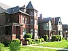
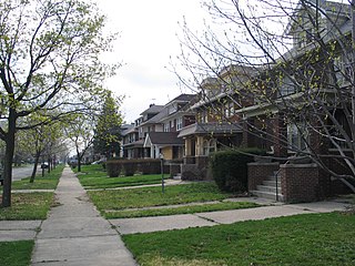
Conant Gardens is in northeast Detroit, Michigan located just west of Detroit's Krainz Woods neighborhood. [9] Houses were built in a variety of architectural styles including Tudor Revival and the Craftsmen style. [10] It is located between Conant Street and the City of Highland Park, north of the City of Hamtramck. Seven Mile Road served as the boundary between Conant Gardens and a white working class area. [11] The neighborhood boundaries are Conant Street, East Seven Mile, Ryan Road, and East Nevada Street. [6] It is located almost 8 miles (13 km) from Paradise Valley. [9] Due to its close proximity to Krainz Woods that neighboring community is sometimes mistaken as being within Conant Gardens.[ citation needed ] Pershing High School is located in Conant Gardens, [12] in proximity to the residential area. [6]
Thomas J. Sugrue, author of The Origins of the Urban Crisis: Race and Inequality in Postwar Detroit, said that Conant Gardens was "more suburban than urban, surrounded by open fields and remote from the city's business and industrial districts." [1] The neighborhood had single family detached houses, many of which had large lawns. The streets were lined with trees. Sugrue said that the houses were modern, the lawns were "well-manicured" and the streets were "quiet". [1]
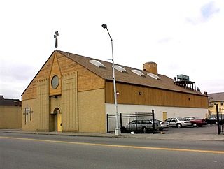
The Double V Bar, a jazz hall, opened in 1942. The Club Deliese, a jazz hall which was owned by Jewish people and had an African American manager, opened in 1945. It changed its name to the "Club El-Morocco" three years after its opening. Lars Bjorn and Jim Gallert, authors of Before Motown: A History of Jazz in Detroit, 1920-60, said that the club remained open until at least 1953 and that Deliese was "the more substantial jazz spot of the two." [11]
By the 1940s and 1950s, Conant Gardens was relatively well-populated. The residents were primarily Black businesspeople, lawyers, ministers, and teachers. [9] In 1950, in terms of all neighborhoods with over 500 black people, the median income of black families and unrelated individuals of the tracts 603 and 604, respectively, were the highest in Detroit; the tracts correspond to Conant Gardens. That year, 60% of the residents owned their houses. [1] Today, the neighborhood is 90.7% Black, 4.9% Native American, 0.9% White, 0.2% Hispanic or Latino, and 3.3% two or more races. [7] 48.8% of today's neighborhood's residents live below the poverty line, which is higher than the city of Detroit's percentage of the population below the poverty line. [7]
Conant Gardens is zoned to Detroit Public Schools. Residents are zoned to Mason K-8 School for elementary and middle school. [13] [14] All residents are zoned to Pershing High School, which has been ranked number 29 of 129 schools in Wayne County for athletics. [15] [16] The current Mason school was the former Farwell Elementary-Middle School. The previous Mason Elementary School closed in 2012 and consolidated into Farwell. [17]
Previously Conant Gardens was zoned to Atkinson Elementary School. [18] At a later point it was zoned to Van Zile Elementary School. [19] Residents were previously zoned to Farwell K-8 for middle school. [20] [21]
Black Bottom was a predominantly black neighborhood in Detroit, Michigan, United States. The term has sometimes been used to apply to the entire neighborhood including Paradise Valley, but many consider the two neighborhoods to be separate. Together, Black Bottom and Paradise Valley were bounded by Brush Street to the west, the Grand Trunk railroad tracks to the east, south to the Detroit River, and bisected by Gratiot Avenue. The area north of Gratiot Avenue to Grand Boulevard was defined as Paradise Valley.
Detroit, the largest city in the state of Michigan, was settled in 1701 by French colonists. It is the first European settlement above tidewater in North America. Founded as a New France fur trading post, it began to expand during the 19th century with American settlement around the Great Lakes. By 1920, based on the booming auto industry and immigration, it became a world-class industrial powerhouse and the fourth-largest city in the United States. It held that standing through the mid-20th century.
Warrendale is a neighborhood located in Detroit, Michigan, bordered by Greenfield Road, Joy Road, and the Detroit city limits. Warrendale neighbors Dearborn on two sides and Dearborn Heights on another side.

Brightmoor is a neighborhood located in Detroit, Michigan, near the northwest border of the city. Brightmoor is defined by the Brightmoor Alliance as being bordered by Puritan Road to the north, the CSX railway to the south, Evergreen Road to the east, and Outer Drive West, Dacosta Street, and Telegraph Road to the west. However, the demographics given here for the neighborhood are the city's statistical Master Plan Neighborhood area, which consists of eight census tracts that includes some areas outside of the Alliance's boundaries, but does not include some areas within its boundaries.
James Madison High School is a public high school located in the Hiram Clarke area of Houston, Texas, United States. The school, located in the Five Corners District, serves grades 9 through 12 and is part of the Houston Independent School District. The school is named after James Madison, the fourth President of the United States.

Lafayette Park is an neighborhood located east of Downtown Detroit. It contains a residential area of some 4,900 people and covers 0.07 sq mi.

Downtown Detroit is the central business district and a residential area of the city of Detroit, Michigan, United States. Locally, downtown tends to refer to the 1.4 square mile region bordered by M-10 to the west, Interstate 75 to the north, I-375 to the east, and the Detroit River to the south. Although, it may also refer to the Greater Downtown area, a 7.2 square mile region that includes surrounding neighborhoods such as Midtown, Corktown, Rivertown, and Woodbridge.

The Boston–Edison Historic District is a neighborhood located in Detroit, Michigan. It consists of over 900 homes built on four east–west streets: West Boston Boulevard, Chicago Boulevard, Longfellow Avenue, and Edison Avenue, stretching from Woodward Avenue on the east to Linwood Avenue on the west. It is one of the largest residential historic districts in the nation. It is surrounded by Sacred Heart Major Seminary to the west, the Arden Park-East Boston Historic District and the Cathedral of the Most Blessed Sacrament to the east, and the Atkinson Avenue Historic District to the south. The district was designated a Michigan State Historic Site in 1973 and listed on the National Register of Historic Places in 1975.
Atkinson Avenue is an east–west street located in the geographic heart of the city of Detroit, Michigan. The historic district had 225 houses in 2010.

The Palmer Woods Historic District is a neighborhood located in Detroit, Michigan, bounded by Seven Mile Road, Woodward Avenue, and Strathcona Drive. There are approximately 295 homes in the 188-acre (0.76 km2) district, which is between the City of Highland Park in Wayne County and the City of Ferndale in Oakland County. It was listed on the National Register of Historic Places in 1983. The Detroit Golf Club is nearby.

The Palmer Park Apartment Building Historic District is a neighborhood located in Detroit, Michigan, bounded by Pontchartrain Boulevard on the west, McNichols Road on the south, and Covington Drive on the northeast. A boundary increase pushed the eastern boundary to Woodward Avenue. The district showcases some of the most ornate and most varied examples of apartment building design in Michigan, and was listed on the National Register of Historic Places in 1983.

Rosedale Park is a historic district located in Detroit, Michigan. It is roughly bounded by Lyndon, Outer Drive, Grand River Avenue, Southfield Freeway, Glastonbury Avenue, Lyndon Street and Westwood Drive. It was listed on the National Register of Historic Places in 2006. The Rosedale Park district has the largest number of individual properties of any district nominated to the National Register of Historic Places in Michigan, with 1533.
Sherwood Forest is a neighborhood in Detroit, Michigan. The neighborhood is bounded by Seven Mile Road, Livernois, Pembroke, and Parkside. The community, with about 435 houses, consists of two subdivisions: Sherwood Forest and Sherwood Forest Manor.
Chaldean Town was a historically Chaldo-Assyrian neighborhood in Detroit located along West Seven Mile Road in a segment in between Woodward Avenue to the west and John R St. to the east. Circa 2007 the population of the district was mainly low income elderly people and recent immigrants, who were mostly made up of Chaldean Catholic Assyrians. The neighborhood was usually just a stop point for newly arrived immigrants, who then typically preferred to move to the suburbs of Detroit when they could afford to.

Springwells is a neighborhood located in Detroit, Michigan, near the Ford Motor Company River Rouge Plant.
Osborn is a community in northeast Detroit, Michigan. The Skillman Foundation selected Osborn to be one of the neighborhoods covered by the Good Neighborhoods Initiative.
Krainz Woods is a neighborhood in Detroit, Michigan.
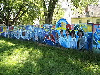
The Detroit Eight Mile Wall, also referred to as Detroit's Wailing Wall, Berlin Wall or The Birwood Wall, is a one-foot-thick (0.30 m), six-foot-high (1.8 m) separation wall that stretches about 1⁄2 mile (0.80 km) in length. 1 foot is buried in the ground and the remaining 5 feet is visible to the community. It was constructed in 1941 to physically separate black and white homeowners on the sole basis of race. The wall no longer serves to racially segregate homeowners and, as of 1971, both sides of the barrier have been predominantly black.

Black Detroiters are black or African American residents of Detroit. According to the U.S. Census Bureau, Black or African Americans living in Detroit accounted for 79.1% of the total population, or approximately 532,425 people as of 2017 estimates. According to the 2000 U.S. Census, of all U.S. cities with 100,000 or more people, Detroit had the second-highest percentage of Black people.

As a strikingly controversial project in 1941, Sojourner Truth Project set precedents for Detroit housing project policy through the next decade. Created by the Detroit Housing Commission (DHC) and United States Housing Authority (USHA), the proposed two-hundred-units would alleviate housing shortages caused by the wartime climate of World War II. However, the project was met with extreme backlash from white residents and middle-class black homeowners in Conant Gardens. Violence erupted in 1942 when black families moved into the project housing. More than a thousand black supporters and white opponents crowded streets culminating in violent displays later characterized as the Sojourner Truth riot.
ISBN 0-9712339-0-X, 2001092511.