Hubbard Farms, Detroit

Last updated
Hubbard Farms' Homes1.jpg

Hubbard Farms is a neighborhood located in Detroit, Michigan. It is located on one of the old plots which used to be a ribbon farm along the Detroit River. It is bound by Clark St to the west, W Vernor Hwy to the north, W Grand Blvd to the east, and W Lafayette Blvd to the south. In 1993, it received its official historic district designation. [1]

Contents

Dating back before French fur traders colonized the Detroit area, the district was used by the Pottawatomie tribes as a local burial ground. After the area was colonized by the French in the 1700s, the land was granted to Robert Navarre, the royal notary at Fort Ponchartrain, who then split the land grant into five ribbon farms along the Detroit River.

After the end of the War of 1812, many English immigrants in the area began to buy subplots and establish smaller farms. One of the first U.S. citizens to own land in the area was Whitmore Knagg, a military interpreter and frontier Indian fighter. He then sold some of this property to the Hubbard family in 1835.

The district was named after Bela Hubbard, a prominent local geologist, lumber baron, land agent, lawyer, farmer, historian and civic leader. In the 1830s, Bela made an early contribution to archaeology: as he surveyed the property, he realized that the area had once been a Pottawatomie village and burial ground. He conducted an excavation and discovered many tribal artifacts. When the State of Michigan was founded in 1837, Bela was named Michigan's first assistant geologist. [2]

Once the Civil War came to an end, Detroit experienced an influx of manufacturing jobs, which created a housing need. Hubbard Farms soon became home to executives and workers such as David Scotten, the owner of the Hiawatha Tobacco Works factory. In 1885, the district was incorporated into Detroit.

Much of the architecture in the community was designed and built between the 1880s and the World War I. Although the area has an overall Victorian feel, the time range for construction and the affluence of the area is reflected in diverse architectural styles and choices. The district features homes that display Romanesque, Colonial Revival, Beaux Arts, Federalist and even Italianate designs.

Places

Hubbard Farms has become a hub for artists and their spaces, with an unusual density of artist-in-residence or other places which carve out creative niches. This is seen in examples like SpreadArt, Southwest Housing Solution's Whitdel building, and El Club. What Pipeline is a contemporary art gallery in the area. Hubbard Farms has a community garden on Hubbard and Vinewood, both north of Porter.

(Hubbard Farms Main) Clark Park Mural.jpg

There is a large park, Clark Park, currently managed by the Clark Park Coalition. It serves as the district’s "town square," hosting festivals, fairs, sporting events and extracurricular activities for the youth in the community. The coalition emerged in 1991 in response to the closing of the park by the Detroit Recreational Department.

Hubbard Farms Maybury Elementary School.jpg

All school grades are located within Hubbard Farms.

Maybury Elementary School - Located across the street from Clark Park, this school has a distinct style of architecture[ clarification needed ], and its white brick stands out from the surrounding homes. Just like its counterparts, Western International High School and Earhart Middle School, the Latino population is evidenced in its student body, which is 78.7% Latino, according to the school’s profile report of 2009. It uniquely offers Spanish literacy for native speakers and a Montessori option PreK-2.

Amelia Earhart Middle School 5-16-2011 Detroit MI.jpg

Amelia Earhart Elementary-Middle School - On the southern edge of the Hubbard Farms is Amelia Earhart Elementary-Middle School. 59.7% of its students are Latino.

Western International High School.jpg

Western International High School - Located across from Clark Park, this high school has evidenced the change in the demographics of the population in the neighborhood since it was built. 61.2% of its students are Latino.

Related Research Articles

<span class="mw-page-title-main">Waterford Township, Michigan</span> Charter township in Michigan, United States

Waterford Township is a charter township in the geographic center of Oakland County, Michigan, United States.

<span class="mw-page-title-main">Grosse Pointe Park, Michigan</span> City in Michigan, United States

Grosse Pointe Park is a city in Wayne County in the U.S. state of Michigan. The population was 11,555 at the 2010 census.

<span class="mw-page-title-main">Corktown, Detroit</span> United States historic place

Corktown is a neighborhood located in Detroit, Michigan. It is the oldest extant neighborhood in the city. The current boundaries of the district include I-75 to the north, the Lodge Freeway to the east, Bagley and Porter streets to the south, and Rosa Parks Boulevard to the west. The neighborhood was listed on the National Register of Historic Places in 1978.

<span class="mw-page-title-main">Mexicantown, Detroit</span>

Mexicantown is a neighborhood located in Detroit, Michigan.

<span class="mw-page-title-main">Fisher Building</span> United States historic place

The Fisher Building is a landmark skyscraper located at 3011 West Grand Boulevard in the heart of the New Center area of Detroit, Michigan. The ornate 30-story building, completed in 1928, is one of the major works of architect Albert Kahn, and is designed in an Art Deco style, faced with limestone, granite, and several types of marble. The Fisher family financed the building with proceeds from the sale of Fisher Body to General Motors. It was designed to house office and retail space.

<span class="mw-page-title-main">Bay Farm Island, Alameda, California</span>

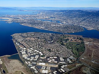
Bay Farm Island is a district of the city of Alameda, California, though it is separated from the rest of the city on Alameda Island by an estuary of San Leandro Bay. Its ZIP code is 94502. The location was originally an island in San Francisco Bay, but due to land reclamation it has become a peninsula and is now connected to the mainland of Oakland and Oakland International Airport. Marshes and other areas of the island were also reclaimed.

<span class="mw-page-title-main">Maybury State Park</span> Park in Michigan, USA

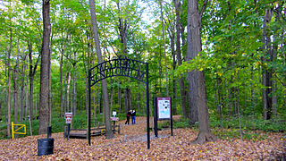
Maybury State Park is a state park in Northville Township, Wayne County, Michigan composed of 944 acres (382 ha) of gently rolling terrain, open meadow, and mature forest. The park gives people in the nearby metropolitan area an opportunity to get involved in outdoor recreation activities in a state park setting. Lying adjacent to the park, Maybury Farm is operated as a separate facility by the Northville Community Foundation.

<span class="mw-page-title-main">Western International High School</span> Public high school in Detroit, Michigan, United States

Western International High School is a public high school, located across from Clark Park, within southwest Detroit's Mexicantown. Western is operated by the Detroit Public Schools system.

<span class="mw-page-title-main">Boston–Edison Historic District</span> Historic district in Michigan, United States

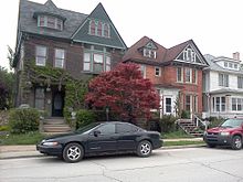
The Boston–Edison Historic District is a neighborhood located in Detroit, Michigan. It consists of over 900 homes built on four east/west streets: West Boston Boulevard, Chicago Boulevard, Longfellow Avenue, and Edison Avenue, stretching from Woodward Avenue on the east to Linwood Avenue on the west. It is one of the largest residential historic districts in the nation. It is surrounded by Sacred Heart Major Seminary to the west, the Arden Park-East Boston Historic District and the Cathedral of the Most Blessed Sacrament to the east, and the Atkinson Avenue Historic District to the south. The district was designated a Michigan State Historic Site in 1973 and listed on the National Register of Historic Places in 1975.

<span class="mw-page-title-main">West Vernor–Junction Historic District</span> Historic district in Michigan, United States

West Vernor–Junction Historic District is a commercial historic district located along West Vernor Highway between Lansing and Cavalry in Detroit, Michigan. The district includes 160 acres (0.65 km2) and 44 buildings. The district was listed on the National Register of Historic Places in 2002.

<span class="mw-page-title-main">Rosedale Park, Detroit</span> United States historic place

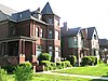
Rosedale Park is a historic district located in Detroit, Michigan. It is roughly bounded by Lyndon, Outer Drive, Grand River Avenue, Southfield Freeway, Glastonbury Avenue, Lyndon Street and Westwood Drive. It was listed on the National Register of Historic Places in 2006. The Rosedale Park district has the largest number of individual properties of any district nominated to the National Register of Historic Places in Michigan, with 1533.

Malcomson and Higginbotham was an architectural firm started in the nineteenth century and based in Detroit, Michigan. A successor firm, Malcomson-Greimel and Associates, still exists in Rochester, Michigan as of 2010.

<span class="mw-page-title-main">Bela Hubbard</span> American lawyer

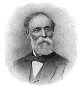
Bela Hubbard was a 19th-century naturalist, geologist, writer, historian, surveyor, explorer, lawyer, real estate dealer, lumberman and civic leader of early Detroit, Michigan. Hubbard is noted as one of the pioneer geologists of Michigan starting with expeditions undertaken, while in his twenties, with Michigan's geologist Douglass Houghton. These early expeditions explored the salt springs of Michigan's Grand and Saginaw river valleys. Later, Hubbard surveyed many of the regions around Lake Superior, Lake Michigan and Lake Huron.

<span class="mw-page-title-main">MorningSide, Detroit</span>

MorningSide is a neighborhood on the east side of Detroit, Michigan. The area is bounded by Harper Avenue and Interstate 94 on the north, Mack Avenue to the south, East Outer Drive and Whittier on the east and Alter Road and East Outer Drive to the west. The local association that shares the name MorningSide with the community is a collaboration of residents working together to take care of this area.

<span class="mw-page-title-main">Trails in Detroit</span>

This is a list of trails and greenways in Detroit.

Southwest Detroit is a neighborhood within Detroit. Clark Park is a popular park within the Hubbard Farms area of southwest Detroit. It is also well known for Mexicantown, Detroit's vibrant Mexican community.

In 2004 58.5% of the people of Hispanic origin in the Wayne County-Macomb County-Oakland County tri-county area were Mexicans.

<span class="mw-page-title-main">Ethnic groups in Metro Detroit</span> Overview of ethnic groups in Metro Detroit

Metro Detroit has the following ethnic groups:

References

[1] [3] [4] [5] [6] [7] [8] [9] [10]

  1. 1 2 "Hubbard Farms Historic District" (PDF). City of Detroit Planning and Development Department. Archived from the original (PDF) on 2012-03-08.
  2. "The Renaissance man who envisioned Grand Boulevard". The Detroit News. 11 May 2014. Retrieved 11 May 2014.
  3. "Hubbard Farms Historic District".
  4. "Clark Park Coalition". Clark Park Coalition.
  5. "Maybury Elementary School". Detroit Public Schools.
  6. "Amelia Earheart Middle School". Detroit Public Schools.
  7. "Western International High School". Detroit Public Schools.
  8. "Armando's Mexican Restaurant". Armando’s Mexican Restaurant. Archived from the original on 2011-05-11.
  9. "Mexicantown Bakery". Mexicantown Bakery. Archived from the original on 2011-05-11.
  10. "Whitdel Arts". Whitdel Arts.

Coordinates: 42°19′08″N83°05′24″W / 42.319°N 83.09°W / 42.319; -83.09