Sherwood Forest, Detroit

Last updated

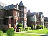
Sherwood Forest is a neighborhood in Detroit, Michigan. The neighborhood is bounded by Seven Mile Road, Livernois, Pembroke, and Parkside. [1] The community, with about 435 houses, consists of two subdivisions: Sherwood Forest and Sherwood Forest Manor. [2]

Contents

The neighborhood was named after Sherwood Forest in Nottinghamshire, England which was the setting for the Robin Hood tales. [3]

History

Sherwood Forest was platted in 1917 by Manly Daniel Davis. [4] The first house appeared in 1922. The Sherwood Forest Association opened in 1929. Most of the houses were built in the late 1920s and 1930s. In 2002 Sherwood Forest became a Detroit Historic District. [2]

Education

Sherwood Forest is within the Detroit Public Schools district. Residents are zoned to Palmer Park Preparatory Academy, formerly the Barbara Jordan School, [5] for elementary and middle school. [6] [7] All residents are zoned to Mumford High School. [8] Palmer Park is operated by teachers and not by a principal administrator. [9]

Detroit Public Library operates the Sherwood Forest Branch Library at 7117 West Seven Mile Road. [3] The library, named after the community, was established in 1942. The current facility opened on February 20, 1951. [10]

Related Research Articles

<span class="mw-page-title-main">Canton, Michigan</span> American township in Michigan

Canton, officially the Charter Township of Canton, is a charter township of Wayne County in the U.S. state of Michigan. As of the 2020 census, the township had a population of 98,659.

<span class="mw-page-title-main">Mexicantown, Detroit</span>

Mexicantown is a neighborhood located in Detroit, Michigan.

Warrendale is a neighborhood located in Detroit, Michigan, bordered by Greenfield East Road, Joy Road, and the Detroit city limits. Warrendale neighbors Dearborn on two sides and Dearborn Heights on another side.

<span class="mw-page-title-main">Midtown Detroit</span> Cultural center and neighborhood in Wayne, Michigan, United States

Midtown Detroit is an commercial and residential district located along the east and west side of Woodward Avenue, north of Downtown Detroit, and south of the New Center area. The area includes several historic districts. In addition, it contains a residential area of some 14,550 people and covers 2.09 sq mi. The community area of neighborhoods is bounded by the Chrysler Freeway (I-75) on the east, the Lodge Freeway (M-10) on the west, the Edsel Ford Freeway (I-94) on the north, and the Fisher Freeway (I-75) on the south.

<span class="mw-page-title-main">Brightmoor, Detroit</span> Neighborhood of Detroit, Michigan

Brightmoor is a neighborhood located in Detroit, Michigan, near the northwest border of the city. Brightmoor is defined by the Brightmoor Alliance as being bordered by Puritan Road to the north, the CSX railway to the south, Evergreen Road to the east, and Outer Drive West, Dacosta Street, and Telegraph Road to the west. However, the demographics given here for the neighborhood are the city's statistical Master Plan Neighborhood area, which consists of eight census tracts that includes some areas outside of the Alliance's boundaries, but does not include some areas within its boundaries.

Conant Gardens is a historically Black neighborhood in northeast Detroit, Michigan. The neighborhood was once the most exclusive Black neighborhood in that city, and residents of Conant Gardens comprised the most highly educated Black enclave in Detroit.

Samuel C. Mumford High School is a public high school located on the near-northwest side of Detroit, Michigan. It was operated by the Detroit Public Schools, and had been operated by the Education Achievement Authority of Michigan (EAA). DPS re-assumed control of Mumford High in fall 2017.

<span class="mw-page-title-main">Parkland, Detroit</span> Neighborhood located in Detroit, Michigan, United States

Parkland is a neighborhood located in the far western section of Detroit, Michigan. The neighborhood is often thought to be part of the neighboring Warrendale neighborhood, which it borders to the east.

<span class="mw-page-title-main">Boston–Edison Historic District</span> Historic district in Michigan, United States

The Boston–Edison Historic District is a neighborhood located in Detroit, Michigan. It consists of over 900 homes built on four east/west streets: West Boston Boulevard, Chicago Boulevard, Longfellow Avenue, and Edison Avenue, stretching from Woodward Avenue on the east to Linwood Avenue on the west. It is one of the largest residential historic districts in the nation. It is surrounded by Sacred Heart Major Seminary to the west, the Arden Park-East Boston Historic District and the Cathedral of the Most Blessed Sacrament to the east, and the Atkinson Avenue Historic District to the south. The district was designated a Michigan State Historic Site in 1973 and listed on the National Register of Historic Places in 1975.

<span class="mw-page-title-main">Atkinson Avenue Historic District</span>

Atkinson Avenue is an east/west street located in the geographic heart of the city of Detroit, Michigan. The historic district had 225 houses in 2010.

<span class="mw-page-title-main">Palmer Woods</span> United States historic place

The Palmer Woods Historic District is a neighborhood located in Detroit, Michigan, bounded by Seven Mile Road, Woodward Avenue, and Strathcona Drive. There are approximately 295 homes in the 188-acre (0.76 km2) district, which is between the City of Highland Park in Wayne County and the City of Ferndale in Oakland County. It was listed on the National Register of Historic Places in 1983. The Detroit Golf Club is nearby.

<span class="mw-page-title-main">Palmer Park Apartment Building Historic District</span> Historic district in Michigan, United States

The Palmer Park Apartment Building Historic District is a neighborhood located in Detroit, Michigan, bounded by Pontchartrain Boulevard on the west, McNichols Road on the south, and Covington Drive on the northeast. A boundary increase pushed the eastern boundary to Woodward Avenue. The district showcases some of the most ornate and most varied examples of apartment building design in Michigan, and was listed on the National Register of Historic Places in 1983.

<span class="mw-page-title-main">Rosedale Park, Detroit</span> United States historic place

Rosedale Park is a historic district located in Detroit, Michigan. It is roughly bounded by Lyndon, Outer Drive, Grand River Avenue, Southfield Freeway, Glastonbury Avenue, Lyndon Street and Westwood Drive. It was listed on the National Register of Historic Places in 2006. The Rosedale Park district has the largest number of individual properties of any district nominated to the National Register of Historic Places in Michigan, with 1533.

<span class="mw-page-title-main">University District, Detroit</span>

University District is a neighborhood in Detroit, Michigan, United States. Located one mile west of Woodward Avenue, the University District is named for its neighbor to the south, the University of Detroit Mercy (UDM). The neighborhood is bounded on the north by residential Seven Mile Road, on the south by McNichols Road and the UDM campus, and on the east by the Detroit Golf Club and Golf Club Estates. The western boundary is Livernois Avenue: once known to Detroiters as "the Avenue of Fashion", this commercial boulevard of small shops is becoming “Gallery Row,” home to a growing collection of art galleries and art-related businesses.

<span class="mw-page-title-main">Chaldean Town</span>

Chaldean Town was a historically Chaldo-Assyrian neighborhood in Detroit located along West Seven Mile Road in a segment in between Woodward Avenue to the west and John R St. to the east. Circa 2007 the population of the district was mainly low income elderly people and recent immigrants, who were mostly made up of Chaldean Catholic Assyrians. The neighborhood was usually just a stop point for newly arrived immigrants, who then typically preferred to move to the suburbs of Detroit when they could afford to.

<span class="mw-page-title-main">Boynton–Oakwood Heights</span> Neighborhoods of Detroit in Wayne, Michigan, United States

Boynton and Oakwood Heights are the two southernmost neighborhoods of the city of Detroit in the U.S. state of Michigan. The two neighborhoods occupy the only portions of Detroit located south of the River Rouge.

Osborn is a community in northeast Detroit, Michigan. The Skillman Foundation selected Osborn to be one of the neighborhoods covered by the Good Neighborhoods Initiative.

Krainz Woods is a neighborhood in Detroit, Michigan.

Southwest Detroit is a neighborhood within Detroit. Clark Park is a popular park within the Hubbard Farms area of southwest Detroit. It is also well known for Mexicantown, Detroit's vibrant Mexican community.

References

  1. "Where We Are Located." Sherwood Forest Association. Retrieved on April 19, 2009.
  2. 1 2 "How Our Neighborhood Began and Grew." Sherwood Forest Association. Retrieved on April 19, 2009.
  3. 1 2 "Sherwood Forest Branch Library." Detroit Public Library . Retrieved on April 19, 2009.
  4. Arthur A. Hagman, ed., Oakland County Book of History (1970), p. 46
  5. "DPS teachers to hold Enrollment Fair for Palmer Park Preparatory Academy, a new teacher-led school." (Archive) Detroit Public Schools. August 13, 2010. Retrieved on November 1, 2012.
  6. "Elementary Boundaries - 2012/13 School Year." (Archive) Detroit Public Schools. Retrieved on November 1, 2012.
  7. "Middle School Boundaries - 2012/13 School Year." (Archive) Detroit Public Schools. Retrieved on November 1, 2012.
  8. "High School Boundaries - 2012/13 School Year." (Archive) Detroit Public Schools. Retrieved on November 1, 2012.
  9. Winerip, Michael. "For Detroit Schools, Mixed Picture on Reforms." The New York Times . March 13, 2011. Retrieved on November 9, 2012.
  10. "Sherwood Forest Library." (Archive) Detroit Public Library. Retrieved on November 8, 2012.

Coordinates: 42°26′09″N83°08′12″W / 42.4357°N 83.1367°W / 42.4357; -83.1367