Inkster is a city in Wayne County in the U.S. state of Michigan. At the 2010 census, the city population was 25,369.

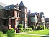
Indian Village is a historic, affluent neighborhood located on Detroit's east side, bound to the north and south by Mack Avenue and East Jefferson Avenue, respectively, along the streets of Burns, Iroquois, and Seminole. The district was listed on the National Register of Historic Places in 1972.
Warrendale is a community in far western Detroit, Michigan. It is bordered by Greenfield East Road, Joy Road, and the Detroit city limits. Warrendale neighbors Dearborn on two sides and Dearborn Heights on another side.

Delray is a neighborhood and former incorporated village located on the southwest side of the city of Detroit in the U.S. state of Michigan. The neighborhood is isolated from other areas of Detroit by industrial warehouses and Interstate 75 (I-75). As a neighborhood, Delray has no legally defined boundaries, but its area usually extends south to the River Rouge, east to the Detroit River, west to M-85 and I-75, and north to Dragoon Street at Fort Wayne or sometimes farther north to Clark Street.

Midtown Detroit is a mixed-use area consisting of a business district, cultural center, a major research university, and several residential neighborhoods, located along the east and west side of Woodward Avenue, north of Downtown Detroit, and south of the New Center area. The community area of neighborhoods is bounded by the Chrysler Freeway (I-75) on the east, the Lodge Freeway (M-10) on the west, the Edsel Ford Freeway (I-94) on the north, and the Fisher Freeway (I-75) on the south. The area includes several historic districts, the Detroit Medical Center, and Wayne State University.

New Center is a commercial and residential historic district located uptown in Detroit, Michigan, adjacent to Midtown, one mile (1.6 km) north of the Cultural Center, and approximately three miles (5 km) north of Downtown. The area is centered just west of the intersection of Woodward Avenue and Grand Boulevard, and is bounded by, and includes the Virginia Park Historic District on the north, the Edsel Ford Freeway (I-94) on the south, John R Street on the east and the Lodge Freeway on the west. New Center, and the surrounding areas north of I-94, are sometimes seen as coterminous with the North End, while in fact separate districts.

Brightmoor is a roughly 4-square-mile (10 km2) neighborhood in Detroit, Michigan, near the northwest border of the city. Brightmoor is defined by the Brightmoor Alliance as being bordered by Puritan Road to the north, the CSX railway to the south, Evergreen Road to the east, and Outer Drive West, Dacosta Street, and Telegraph Road to the west. However, the demographics given here for the neighborhood are the city's statistical Master Plan Neighborhood area, which consists of eight census tracts that includes some areas outside of the Alliance's boundaries, but does not include some areas within its boundaries.
Conant Gardens is a historically Black neighborhood in northeast Detroit, Michigan. The neighborhood was once the most exclusive Black neighborhood in that city, and residents of Conant Gardens comprised the most highly educated Black enclave in Detroit.

Downtown Detroit is the central business district and a residential area of the city of Detroit, Michigan, United States. Locally, downtown tends to refer to the 1.4 square mile region bordered by M-10 to the west, Interstate 75 to the north, I-375 to the east, and the Detroit River to the south. Although, it may also refer to the Greater Downtown area, a 7.2 square mile region that includes surrounding neighborhoods such as Midtown, Corktown, Rivertown, and Woodbridge.
Parkland is a neighborhood located in the far western section of Detroit, Michigan. The neighborhood is often thought to be part of the neighboring Warrendale neighborhood, which it borders to the east.

The Arden Park–East Boston Historic District is a neighborhood in the City of Detroit, Michigan, bounded on the west by Woodward Avenue, on the north by East Boston Boulevard, on the east by Oakland Avenue, and on the south by Arden Park Boulevard. The area is immediately adjacent to the larger Boston-Edison Historic District, on the opposite side of Woodward Avenue, and is in close proximity to Atkinson Avenue. There are 92 homes in the district, all on East Boston and Arden Park Boulevards. Arden Park Boulevard and East Boston Boulevard feature prominent grassy medians with richly planted trees and flowers. The setbacks of the homes are deep, with oversized lots. The district was listed on the National Register of Historic Places in 1982.

The Boston–Edison Historic District is a historic neighborhood located in the geographic center of Detroit, Michigan. It consists of over 900 homes built on four east/west streets: West Boston Boulevard, Chicago Boulevard, Longfellow Avenue, and Edison Avenue, stretching from Woodward Avenue on the east to Linwood Avenue on the west. It is one of the largest residential historic districts in the nation. It is surrounded by Sacred Heart Major Seminary to the west, the Arden Park-East Boston Historic District and the Cathedral of the Most Blessed Sacrament to the east, and the Atkinson Avenue Historic District to the south. The district was designated a Michigan State Historic Site in 1973 and listed on the National Register of Historic Places in 1975.

The Virginia Park Historic District is located on the north side of New Center, an area in Detroit, Michigan, along both sides of Virginia Park Street from Woodward Avenue to the John C. Lodge Freeway access road. The district was listed on the National Register of Historic Places in 1982.

The Palmer Woods Historic District is a residential historic district bounded by Seven Mile Road, Woodward Avenue, and Strathcona Drive in Detroit, Michigan. There are approximately 295 homes in the 188-acre (0.76 km2) district, which is between the City of Highland Park in Wayne County and the City of Ferndale in Oakland County. It was listed on the National Register of Historic Places in 1983. The Detroit Golf Club is nearby.

The Palmer Park Apartment Building Historic District is a historic district located in Detroit, Michigan. It is roughly bounded by Pontchartrain Boulevard on the west, McNichols Road on the south, and Covington Drive on the northeast. A boundary increase pushed the eastern boundary to Woodward Avenue. The district showcases some of the most ornate and most varied examples of apartment building design in Michigan, and was listed on the National Register of Historic Places in 1983.

Rosedale Park is a historic district located in Detroit, Michigan. It is roughly bounded by Lyndon, Outer Drive, Grand River Avenue, Southfield Freeway, Glastonbury Avenue, Lyndon Street and Westwood Drive. It was listed on the National Register of Historic Places in 2006. The Rosedale Park district has the largest number of individual properties of any district nominated to the National Register of Historic Places in Michigan, with 1533.
Sherwood Forest is an area in Detroit, Michigan, United States. The district is bounded by Seven Mile Road, Livernois, Pembroke, and Parkside. The community, with about 435 houses, consists of two subdivisions: Sherwood Forest and Sherwood Forest Manor.

Boynton and Oakwood Heights are the two southernmost neighborhoods of the city of Detroit in the U.S. state of Michigan. They occupy the only portions of Detroit located south of the River Rouge. According to the U.S. Census Bureau, the two neighborhoods have a combined total area of 2.80 square miles (7.25 km2). Boynton and Oakwood Heights had a combined population of 8,832 in the 2010 census, which was a 21.9% decrease from its population of 10,516 in the 2000 census. The majority of residents reside in the larger Boynton neighborhood, as entire blocks of Oakwood Heights have been cleared out to make room for potential industrial expansion.
Osborn is a community in northeast Detroit, Michigan. The Skillman Foundation selected Osborn to be one of the neighborhoods covered by the Good Neighborhoods Initiative.
Krainz Woods is a neighborhood in Detroit, Michigan.