Wayne County is the most populous county in the U.S. state of Michigan. As of 2020, the United States Census placed its population at 1,793,561, making it the 19th-most populous county in the United States. The county seat is Detroit. The county was founded in 1796 and organized in 1815. Wayne County is included in the Detroit-Warren-Dearborn, MI Metropolitan Statistical Area. It is one of several U.S. counties named after Revolutionary War-era general Anthony Wayne.
Black Bottom was a predominantly black neighborhood in Detroit, Michigan. The term has sometimes been used to apply to the entire neighborhood including Paradise Valley, but many consider the two neighborhoods to be separate. Together, Black Bottom and Paradise Valley were bounded by Brush Street to the west, the Grand Trunk railroad tracks to the east, south to the Detroit River, and bisected by Gratiot Avenue. The area north of Gratiot Avenue to Grand Boulevard was defined as Paradise Valley.

Corktown is a neighborhood located in Detroit, Michigan. It is the oldest extant neighborhood in the city. The current boundaries of the district include I-75 to the north, the John C. Lodge Freeway to the east, Bagley and Porter streets to the south, and Rosa Parks Boulevard to the west. The neighborhood was listed on the National Register of Historic Places in 1978.

M-10 is a state trunkline highway in the Metro Detroit area of Michigan in the United States. Nominally labeled north-south, the route follows a northwest-southeast alignment. The southernmost portion follows Jefferson Avenue in downtown Detroit, and the southern terminus is at the intersection of Jefferson and M-3 next to the entrance to the Detroit–Windsor Tunnel. The northern terminus is in West Bloomfield Township at the intersection with Orchard Lake Road. The highway has several names as it runs through residential and commercial areas of the west side of Detroit and into the suburb of Southfield. It is called the John C. Lodge Freeway, James Couzens Highway, and Northwestern Highway. One segment has also been named the Aretha Franklin Memorial Highway.

Midtown Detroit is a commercial and residential district located along the east and west side of Woodward Avenue, north of Downtown Detroit, and south of the New Center area. The area includes several historic districts. In addition, it contains a residential area of some 14,550 people and covers 2.09 sq mi. The community area of neighborhoods is bounded by the Chrysler Freeway (I-75) on the east, the Lodge Freeway (M-10) on the west, the Edsel Ford Freeway (I-94) on the north, and the Fisher Freeway (I-75) on the south.

New Center is a commercial and residential district located in Detroit, Michigan, adjacent to Midtown, one mile (1.6 km) north of the Cultural Center, and approximately three miles (5 km) north of Downtown. The area is centered just west of the intersection of Woodward Avenue and Grand Boulevard, and is bounded by, and includes the Virginia Park Historic District on the north, the Edsel Ford Freeway (I-94) on the south, John R Street on the east and the Lodge Freeway on the west. New Center, and the surrounding areas north of I-94, are sometimes seen as coterminous with the North End, while in fact separate districts.

The architecture of metropolitan Detroit continues to attract the attention of architects and preservationists alike. With one of the world's recognizable skylines, Detroit's waterfront panorama shows a variety of architectural styles. The post-modern neogothic spires of One Detroit Center refer to designs of the city's historic Art Deco skyscrapers. Together with the Renaissance Center, they form the city's distinctive skyline.

Washington Boulevard Historic District is a multi-block area of downtown Detroit, Michigan. It consists of structures facing Washington Boulevard between State and Clifford Streets. In 1982, it was added to the National Register of Historic Places. It includes the Book-Cadillac Hotel, the Book Tower, the Industrial Building, and Detroit City Apartments among other architecturally significant buildings. Washington Boulevard is one of the city's main boulevards and part of Augustus Woodward's 1807-design for the city. Because Woodward's plan was never completed, the boulevard contains a sharp curve south of Michigan Avenue where it was connected to an existing street.

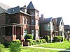
The Arden Park–East Boston Historic District is a neighborhood located in Detroit, Michigan, bounded on the west by Woodward Avenue, on the north by East Boston Boulevard, on the east by Oakland Avenue, and on the south by Arden Park Boulevard. The area is immediately adjacent to the much larger and better-known Boston-Edison Historic District, which is on the west side of Woodward Avenue, and also close to the Atkinson Avenue which is just south of Boston-Edison. There are 92 homes in the district, all on East Boston or Arden Park Boulevards. Arden Park Boulevard and East Boston Boulevard feature prominent grassy medians with richly planted trees and flowers. The setbacks of the homes are deep, with oversized lots. The district was listed on the National Register of Historic Places in 1982.

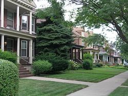
The Boston–Edison Historic District is a neighborhood located in Detroit, Michigan. It consists of over 900 homes built on four east-west streets: West Boston Boulevard, Chicago Boulevard, Longfellow Avenue and Edison Avenue, stretching from Woodward Avenue in the east to Linwood Avenue in the west. It is one of the largest residential historic districts in the nation. It is surrounded by Sacred Heart Major Seminary to the west, the Arden Park-East Boston Historic District and the Cathedral of the Most Blessed Sacrament to the east, and the Atkinson Avenue Historic District to the south. The district was designated a Michigan State Historic Site in 1973 and listed on the National Register of Historic Places in 1975.

The Virginia Park Historic District is located on the north side of New Center, an area in Detroit, Michigan, along both sides of Virginia Park Street from Woodward Avenue to the John C. Lodge Freeway access road. The district was listed on the National Register of Historic Places in 1982.

This is a list of the National Register of Historic Places listings in Detroit, Michigan.

The Hunter House is located at 3985 Trumbull Avenue in the Woodbridge Neighborhood Historic District of Detroit, Michigan. The house was listed on the National Register of Historic Places and designated a Michigan State Historic Site in 1974. It was previously operated as the Woodbridge Star, a bed and breakfast.

The East Grand Boulevard Historic District is a historic district located along East Grand Boulevard between East Jefferson Avenue and Mack Avenue in Detroit, Michigan. The district was listed on the National Register of Historic Places in 1999.

The University–Cultural Center MRA is a pair of multiple property submissions to the National Register of Historic Places which were approved on April 29 and May 1, 1986. The structures included are all located in Midtown, near Woodward Avenue and Wayne State University in Detroit, Michigan. The two submissions are designated the University–Cultural Center MRA Phase I, containing five properties, and the University–Cultural Center MRA Phase II, containing three properties.

The Cass Farm MPS is a US multiple property submission to the National Register of Historic Places which was approved on December 1, 1997. The structures included are all located in Midtown, in the Cass Farm area in Detroit, Michigan, USA. The Cass Farm area is defined as occupying the space between Woodward Avenue on the east, the Lodge Freeway on the west, Warren Avenue on the north, and Martin Luther King Jr. Boulevard on the south.

The former Eighth Precinct Police Station is a building located at 4150 Grand River Avenue in the Woodbridge Historic District of Detroit, Michigan, United States. It is the second-oldest police building in Detroit, and was designated a Michigan State Historic Site in 1973 and listed on the National Register of Historic Places in 1974. The building now houses the Detroit Castle Lofts.

This is a list of the National Register of Historic Places listings in Downtown and Midtown Detroit, Michigan. It is intended to be a complete list of the properties and districts on the National Register of Historic Places in Downtown and Midtown neighborhoods in Detroit, Michigan, United States. Latitude and longitude coordinates are provided for many National Register properties and districts; these locations may be seen together in online maps.

The New Center Commercial Historic District is a commercial historic district located on Woodward Avenue between Baltimore Street and Grand Boulevard in Detroit, Michigan. It was listed on the National Register of Historic Places in 2016.