
The Weka Pass Railway is a New Zealand heritage railway based in Waipara, North Canterbury. It is operated on a 12.8 km length of the former Waiau Branch railway between Waipara and Waikari. The railway is operated by an incorporated society which consists solely of members and volunteers, and are largely resident in the city of Christchurch, 60 km to the south. The railway began carrying passengers in 1984 and is now well established locally and nationally.

Templecombe railway station serves the town of Templecombe in Somerset, England. It is situated on the West of England Main Line, 112 miles 2 chains (180.3 km) down the line from London Waterloo. The main station opened in 1860 but a smaller station on the lower line opened in 1862. It was closed in 1966 but was reopened in 1983 following local community pressure. It is currently operated by South Western Railway.
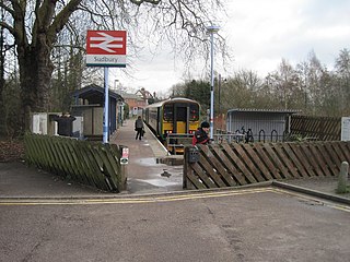
Sudbury railway station is the northern terminus of the Gainsborough Line, a branch off the Great Eastern Main Line in the East of England, serving the town of Sudbury, Suffolk. It is 11 miles 67 chains (19.05 km) down the line from the southern terminus of Marks Tey and 58 miles 32 chains (93.99 km) measured from London Liverpool Street; the preceding station on the branch is Bures. Its three-letter station code is SUY. The platform has an operational length for two-coach trains.

Penzance railway station serves the town of Penzance in west Cornwall, England. It is the terminus of the Cornish Main Line and the southernmost railway station in Great Britain, situated at milepost 326.5 miles (525.5 km) from London Paddington. The station is owned by Network Rail and managed by Great Western Railway, which also operates train services together with CrossCountry.
The Tuatapere Branch, including the Orawia Branch, was a branch line railway in Southland, New Zealand. Although the Tuatapere and Orawia Branches look like a single line, operationally they were considered separate lines. The first section opened to Riverton in 1879 and reached Tuatapere three decades later. The extension from Tuatapere to Orawia operated from 1925 until 1970. In 1976 the Tuatapere Branch was truncated to Riverton, and was known as the Riverton Branch until 1978, when it closed beyond Thornbury. The remaining portion of the line is now part of the Wairio Branch.
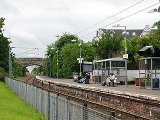
North Berwick railway station is a railway station serving the seaside town of North Berwick in East Lothian, Scotland. It is the terminus of the Edinburgh to North Berwick Line, 22+1⁄4 miles (35.8 km) east of Edinburgh Waverley.

Pickering railway station is the southern terminus of the North Yorkshire Moors Railway and serves the town of Pickering in North Yorkshire, England. The first railway arrived in Pickering from the north in 1836, however, it wasn't until the railway was connected from the south in 1845, that the current station was built. The station was closed by British Railways in March 1965, but since 1975, the station has served as the southern terminus of the North York Moors Railway.
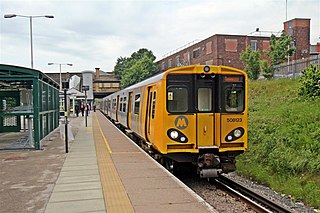
Waterloo railway station is a railway station in Waterloo, Merseyside, England, on the Northern Line of the Merseyrail network. It serves a largely residential area, although there is a number of shops along South Road, where the station entrance is situated.

The Whitecliffs Branch was an 18.4 kilometres (11.4 mi) long branch line railway that formed part of New Zealand's national rail network in the Canterbury region of the South Island. It was more industrial than the many rural branches on the South Island's east coast whose traffic primarily derived from agriculture, and it operated from 1875 until 1962.
The Waiau Branch was a branch line railway in the northern Canterbury region of New Zealand's South Island. Known as the Great Northern Railway for its first few decades of life, the Waiau Branch was seen as part of a main line north but was ultimately superseded by a coastal route. Opened in stages from 1882 to 1919, the line closed in 1978 but a portion has been retained as the Weka Pass Railway.

Culverden is a small town in the northern Canterbury region of New Zealand's South Island. It lies at the centre of the Amuri Plain. Culverden has traditionally been surrounded by sheep farms. Dairy farms have now become more common as a result of irrigation schemes in the area. The Waiau Plains Irrigation Scheme was completed in 1980. It provides irrigation to 17,000 hectares of farmland and the Balmoral Scheme provides irrigation to a further 5500 hectares.

Rotherham is a small village in the Hurunui District of the Canterbury region in New Zealand's South Island. It is between Culverden and Waiau on the Inland Kaikōura Road, on the northernmost part of the Amuri Plain. It lies near the south bank of the Waiau Uwha River, a popular location for trout and salmon fishing.

The Main North Line, sometimes referred to as part of the South Island Main Trunk railway, is a railway line that runs north from Christchurch in New Zealand up the east coast of the South Island through Kaikōura and Blenheim to Picton. It is a major link in New Zealand's national rail network and offers a connection with roll-on roll-off ferries from Picton to Wellington. It was also the longest railway construction project in New Zealand's history, with the first stages built in the 1870s and not completed until 1945.

Seymour railway station is on the North East line in Victoria, Australia. It serves the town of Seymour, and opened on 20 November 1872. The station is the terminus for V/Line's Seymour line services.

Watchet railway station is a station on the West Somerset Railway, a heritage railway in Somerset, England. It is situated in the small harbour town of Watchet.

The Devon and Somerset Railway (D&SR) was a cross-country line that connected Barnstaple in Devon, England, to the network of the Bristol and Exeter Railway (B&ER) near Taunton. It was opened in stages between 1871 and 1873 and closed in 1966. It served a mostly rural area although it carried some through services from east of Taunton to the seaside resort of Ilfracombe.

There are eleven disused railway stations on the Exeter to Plymouth line between Exeter St Davids and Plymouth Millbay in Devon, England. At eight of these there are visible remains.
Glenpark is a lightly populated rural locality in the Otago region of New Zealand's South Island. It is northwest of Palmerston and is on the banks of the Shag River. To the west is the locality of Stoneburn.

The East Norfolk Railway was a pre-grouping railway company operating a standard gauge 25 mile, mostly single track, railway running between Norwich Thorpe railway station and Cromer in the English county of Norfolk. It opened in 1874, reaching Cromer three years later, and remains mostly operational. The company also operated a branch between Wroxham and County School, which closed to passengers in 1952, and had proposed a branch to Blakeney in 1878, which was never constructed.

Bricklayers Arms was a railway station in Southwark opened by the London and Croydon Railway and the South Eastern Railway in 1844 as an alternative to the London and Greenwich Railway's terminus at London Bridge. The station was at the end of a short branch line from the main line to London Bridge and served as a passenger terminus for a few years before being converted to a goods station and engineering facility. The goods station closed in 1981.
