Culverden

Last updated

Culverden
town
Culverden Main Street 001.JPG
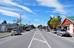
Mountainview Road (New Zealand State Highway 7) in Culverden
Culverden
Coordinates: 42°46′S172°51′E / 42.767°S 172.850°E / -42.767; 172.850
Country New Zealand
Region Canterbury
Territorial authority Hurunui District
WardWest Ward
Electorates
Government
  Territorial Authority Hurunui District Council
  Regional council Environment Canterbury
   Mayor of Hurunui Marie Black
   Kaikōura MP Stuart Smith
   Te Tai Tonga MP Tākuta Ferris
Area
[1]
  Total1.04 km2 (0.40 sq mi)
Elevation
179 m (587 ft)
Population
 (June 2023) [2]
  Total370
  Density360/km2 (920/sq mi)
Time zone UTC+12 (New Zealand Standard Time)
  Summer (DST) UTC+13 (New Zealand Daylight Time)
Postcode
7392
Area code 03
Local iwi Ngāi Tahu

Culverden is a small town in the northern Canterbury region of New Zealand's South Island. It lies at the centre of the Amuri Plain. Culverden has traditionally been surrounded by sheep farms. Dairy farms have now become more common as a result of irrigation schemes in the area. The Waiau Plains Irrigation Scheme was completed in 1980. It provides irrigation to 17,000 hectares of farmland and the Balmoral Scheme provides irrigation to a further 5500 hectares. [3]

Contents

The Health Department encouraged the Amuri County Council to install a water supply in Culverden as a result of a "slight epidemic" of hepatitis which was traced back to contaminated water. A town water supply was built in 1965. [3]

Rubbish collection began in Culverden in 1972. A proposal to provide Culverden with a sewage scheme in 1983 was approved by the Amuri County Council. Residents were unhappy with the cost of it and it was never built. Culverden was still without a sewage scheme in 2000. Culverden had its telephone exchange upgraded to an automatic exchange in 1984. The Bank of New Zealand closed its branch in Culverden in 1988. [3]

The Rutherford Reserve and the Culverden Recreation Reserve are on the southern side of Culverden and the Culverden Golf Course in on the northern entrance to Culverden. There is a memorial in the Rutherford Reserve to Dr Charles Little who died in November 1918 from the Spanish Flu. He was the county doctor providing medical services from Waikari to Waiau. [4]

Local government

When provincial government was abolished in 1876, Culverden became the main centre for the newly established Amuri County. Counties were abolished in the 1989 local government reforms, and since then, Culverden has belonged to the Hurunui District. [5]

Demographics

Culverden is described by Statistics New Zealand as a rural settlement and covers 1.04 km2 (0.40 sq mi). [1] It had an estimated population of 370 as of June 2023, [2] with a population density of 356 people per km2. Culverden is part of the larger Amuri statistical area. [6]

Historical population for Culverden
YearPop.±% p.a.
2006345    
2013366+0.85%
2018351−0.83%
Source: [7]
Memorial to Dr Charles Little in Culverden C Little memorial Culverden 2.jpg
Memorial to Dr Charles Little in Culverden

Culverden had a population of 351 at the 2018 New Zealand census, a decrease of 15 people (−4.1%) since the 2013 census, and an increase of 6 people (1.7%) since the 2006 census. There were 153 households, comprising 159 males and 192 females, giving a sex ratio of 0.83 males per female, with 72 people (20.5%) aged under 15 years, 63 (17.9%) aged 15 to 29, 159 (45.3%) aged 30 to 64, and 54 (15.4%) aged 65 or older.

Ethnicities were 89.7% European/Pākehā, 10.3% Māori, 7.7% Asian, and 1.7% other ethnicities. People may identify with more than one ethnicity.

Although some people chose not to answer the census's question about religious affiliation, 40.2% had no religion, 47.9% were Christian, 0.9% were Buddhist and 3.4% had other religions.

Of those at least 15 years old, 36 (12.9%) people had a bachelor's or higher degree, and 84 (30.1%) people had no formal qualifications. 33 people (11.8%) earned over $70,000 compared to 17.2% nationally. The employment status of those at least 15 was that 150 (53.8%) people were employed full-time, 42 (15.1%) were part-time, and 3 (1.1%) were unemployed. [7]

Amuri statistical area

Amuri statistical area, which includes Culverden, Rotherham and Waiau, covers 1,835.61 km2 (708.73 sq mi). [1] It had an estimated population of 2,480 as of June 2023, [8] with a population density of 1.4 people per km2.

Historical population for Amuri
YearPop.±% p.a.
20062,001    
20132,097+0.67%
20182,223+1.17%
Source: [9]

Amuri had a population of 2,223 at the 2018 New Zealand census, an increase of 126 people (6.0%) since the 2013 census, and an increase of 222 people (11.1%) since the 2006 census. There were 834 households, comprising 1,173 males and 1,047 females, giving a sex ratio of 1.12 males per female. The median age was 34.4 years (compared with 37.4 years nationally), with 507 people (22.8%) aged under 15 years, 417 (18.8%) aged 15 to 29, 1,056 (47.5%) aged 30 to 64, and 246 (11.1%) aged 65 or older.

Ethnicities were 82.9% European/Pākehā, 10.8% Māori, 0.8% Pasifika, 11.3% Asian, and 3.4% other ethnicities. People may identify with more than one ethnicity.

The percentage of people born overseas was 21.7, compared with 27.1% nationally.

Although some people chose not to answer the census's question about religious affiliation, 49.5% had no religion, 40.2% were Christian, 0.1% had Māori religious beliefs, 1.2% were Hindu, 0.3% were Muslim and 2.3% had other religions.

Of those at least 15 years old, 303 (17.7%) people had a bachelor's or higher degree, and 327 (19.1%) people had no formal qualifications. The median income was $38,600, compared with $31,800 nationally. 258 people (15.0%) earned over $70,000 compared to 17.2% nationally. The employment status of those at least 15 was that 1,047 (61.0%) people were employed full-time, 297 (17.3%) were part-time, and 30 (1.7%) were unemployed. [9]

Notable Buildings

Amuri County Offices

Amuri County Office, Culverden Culverden Amuri County Office.jpg
Amuri County Office, Culverden

This was designed in a Georgian style. It was earthquake damaged and the Hurunui District Council was looking at repairing and strengthening the building. [10] It was for sale in October 2020.

Amuri Co-operating Church

The Amuri Co-operating Church, formerly Saint Andrews Presbyterian Church, Culverden, It has a stained glass window entitled "Christ the Shepherd and Sheep Farmer", designed by Beverley Shore Bennett and executed by Roy Miller in 1973. [11]

Amuri Co-operating Church Amuri Church.jpg
Amuri Co-operating Church

Mockett Motors

Mockett Motors is designed in a Art Deco style. The business has been present in Culverden for over 100 years, [12]

Mockett Motors, Built in an Art Deco Style. Mockett Motors.jpg
Mockett Motors, Built in an Art Deco Style.

Transport

State Highway 7 passes through Culverden, forming the town's main street.

Culvenden was also once an important railway terminus, with the railway line extended from Medbury across the Hurunui River to Culverden on 8 February 1886. It was envisaged that this route would become the Main North Line to Nelson and Blenheim, but a coastal route via Parnassus and Kaikōura was chosen instead. Nonetheless, the branch line to Culverden was extended beyond the town to Waiau in 1919 and it became known as the Waiau Branch. At the line's peak, when it was considered to be part of the Main North Line, multiple trains ran daily between Culverden and Christchurch, including the Culverden Express and a number of slower mixed trains that carried both freight and passengers. However, regular passenger services were replaced by buses on 29 January 1939 and after becoming uneconomic, the railway through Culverden was closed entirely on 15 January 1978. Little now remains of the town's railway except a loading bank at the site of the old station.

Education

Amuri Area School is the sole school in Culverden, catering for Year 1 to 13 students (ages 5 to 18), with a roll of approximately 344 students. [13] [14]

Notable people

Cricketer Amy Satterthwaite (born 1986) grew up in Culverden. [15]

Sport

The Kaiwara Classic Mountain Bike Race starts in Culverden and Cheviot via the Kaiwara Road. [16] [17]

Related Research Articles

<span class="mw-page-title-main">Coromandel, New Zealand</span> Town in Waikato, New Zealand

Coromandel, also called Coromandel Town to distinguish it from the wider district, is a town on the Coromandel Harbour, on the western side of the Coromandel Peninsula, which is in the North Island of New Zealand. It is 75 kilometres east of the city of Auckland, although the road between them, which winds around the Firth of Thames and Hauraki Gulf coasts, is 190 km long. The population was 1,930 as of June 2023.

<span class="mw-page-title-main">Amberley, New Zealand</span> Town in Canterbury, New Zealand

Amberley is a town located in the Hurunui District in north Canterbury, on the east coast of the South Island of New Zealand. It is located on State Highway 1 approximately 50 km north of Christchurch. It is the seat of the Hurunui District Council. The nearest town to the north of Amberly via state highway one is Waipara (11 km) and the nearest town to the south is Leithfield (5.7 km).

<span class="mw-page-title-main">Cheviot, New Zealand</span> Town in Canterbury, New Zealand

Cheviot is a town in the Hurunui District of north Canterbury, on the east coast of the South Island of New Zealand. It is located on State Highway 1, approximately 112 kilometres (70 mi) north of Christchurch and 68 kilometres (42 mi) south of Kaikōura.

<span class="mw-page-title-main">Leithfield</span> Town in Canterbury, New Zealand

Leithfield is a small town in north Canterbury, New Zealand. It is on State Highway 1, 5 kilometres (3.1 mi) south of Amberley and 42 kilometres (26 mi) north of Christchurch and 11.8 kilometres north of Waikuku. The Leithfield area consists of two semi-distinct areas, Leithfield Beach to the east of State Highway 1 and Leithfield Village adjacent to and immediately to the west of State Highway 1. Leithfield sits just south of the South Branch of the Kowai River.

<span class="mw-page-title-main">Waipara</span> Town in Canterbury, New Zealand

Waipara is a small town in north Canterbury, New Zealand, on the banks of the Waipara River. Its name translates to "Muddy Water", wai meaning water and para meaning mud.

<span class="mw-page-title-main">Kaikōura District</span> District in Canterbury, New Zealand

The Kaikōura District is a territorial authority district in Canterbury Region on the South Island of New Zealand. The district encompasses the eponymous town of Kaikōura, a number of small towns and settlements and the surrounding rural area in northern Canterbury. The district had an estimated population of 4,230 as of June 2023.

<span class="mw-page-title-main">Westland District</span> Territorial authority district in West Coast, New Zealand

Westland District is a territorial authority district on the West Coast of New Zealand's South Island. It is administered by the Westland District Council. The district's population is 8,940.

<span class="mw-page-title-main">Hurunui District</span> Territorial authority district in Canterbury, New Zealand

Hurunui District is a territorial local government district within the Canterbury Region on the east coast of New Zealand's South Island, north of Christchurch. It stretches from the east coast to the Main Divide. Its land area is 8,640.96 square kilometres (3,336.29 sq mi).

<span class="mw-page-title-main">Waimakariri District</span> Territorial authority district in South Island, New Zealand

Waimakariri District is a local government district, located in the Canterbury Region of New Zealand's South Island. It is named after the Waimakariri River, which forms the district's southern boundary, separating it from Christchurch City and the Selwyn District. It is bounded in the north by the Hurunui District and in the east by the Pacific Ocean.

<span class="mw-page-title-main">Waiau, Canterbury</span> Town in Canterbury, New Zealand

Waiau is a small town in north Canterbury, in the South Island of New Zealand. It lies 30 kilometres (19 mi) east of Hanmer Springs on the northern bank of the Waiau Uwha River, some 30 kilometres (19 mi) from the river's mouth. There is a small supermarket, a DIY store and a petrol station.

<span class="mw-page-title-main">Waikari</span> Town in Canterbury, New Zealand

Waikari is a small town in the Canterbury region of New Zealand's South Island.

<span class="mw-page-title-main">Hawarden, New Zealand</span> Town in Canterbury, New Zealand

Hawarden is a small town in the Canterbury region of New Zealand's South Island. It is located near Waikari, just off State Highway 7.

<span class="mw-page-title-main">Rotherham, New Zealand</span> Town in Canterbury, New Zealand

Rotherham is a small village in the Hurunui District of the Canterbury region in New Zealand's South Island. It is between Culverden and Waiau on the Inland Kaikōura Road, on the northernmost part of the Amuri Plain. It lies near the south bank of the Waiau Uwha River, a popular location for trout and salmon fishing.

<span class="mw-page-title-main">Parnassus, New Zealand</span> Locality in Canterbury, New Zealand

Parnassus is a locality in the Canterbury region's Hurunui District on the east coast of New Zealand's South Island. It is located on the north bank of the Waiau River.

<span class="mw-page-title-main">Franz Josef / Waiau</span> Town in the West Coast Region of New Zealand

Franz Josef is a small town in the West Coast region of the South Island of New Zealand. Whataroa is 32 kilometres (20 mi) to the north-east, and the township of Fox Glacier is 23 kilometres (14 mi) to the south-west. The Waiho River runs from the Franz Josef Glacier to the south, through the town, and into the Tasman Sea to the north-west.

<span class="mw-page-title-main">Pukenui</span> Place in Northland Region, New Zealand

Pukenui is a locality on the southwest side of Houhora Harbour on the Aupouri Peninsula of Northland, New Zealand. State Highway 1 runs through it. The name means "large hill" in the Māori language.

Amuri County is one of the former counties of New Zealand, in the area that is now the north of Canterbury region.

<span class="mw-page-title-main">Waiau Pa</span> Place in Auckland Region, New Zealand

Waiau Pa is a small town of Auckland, New Zealand. It is in the Franklin Ward of Auckland Council. The name means "River of swirling currents" in the Māori language.

The Amuri Plain is the northernmost extension of New Zealand's Canterbury Plains. It lies between the Waiau Uwha and Hurunui Rivers and is centred on the town of Culverden. Other population centres on the plain include Rotherham. The plains cover approximately 60,000 hectares.

<span class="mw-page-title-main">Thornton Bay</span> Rural settlement in Waikato, New Zealand

Thornton Bay is a settlement on the west coast of the Coromandel Peninsula of New Zealand, between Te Puru to the north and Whakatete Bay to the south. State Highway 25 runs through it. Ngarimu Bay immediately to the south is considered to be part of the same urban area by Statistics New Zealand.

References

  1. 1 2 3 "ArcGIS Web Application". statsnz.maps.arcgis.com. Retrieved 24 August 2021.
  2. 1 2 "Subnational population estimates (RC, SA2), by age and sex, at 30 June 1996-2023 (2023 boundaries)". Statistics New Zealand . Retrieved 25 October 2023. (regional councils); "Subnational population estimates (TA, SA2), by age and sex, at 30 June 1996-2023 (2023 boundaries)". Statistics New Zealand . Retrieved 25 October 2023. (territorial authorities); "Subnational population estimates (urban rural), by age and sex, at 30 June 1996-2023 (2023 boundaries)". Statistics New Zealand . Retrieved 25 October 2023. (urban areas)
  3. 1 2 3 Lovell-Smith, Margaret (2000). Hurunui Heritage The Development of a district 1950-2000. New Zealand: Hurunui District Council. pp. 74, 111–130. ISBN   0-473-07135-5.
  4. "Dr Charles Little". my.christchurchcitylibraries.com. Retrieved 8 October 2020.
  5. Wilson, John. "Canterbury places - Amuri district". Te Ara: The Encyclopedia of New Zealand . Retrieved 9 January 2017.
  6. 2018 Census place summary: Amuri
  7. 1 2 "Statistical area 1 dataset for 2018 Census". Statistics New Zealand. March 2020. 7023834 and 7023835.
  8. "Population estimate tables - NZ.Stat". Statistics New Zealand . Retrieved 25 October 2023.
  9. 1 2 "Statistical area 1 dataset for 2018 Census". Statistics New Zealand. March 2020. Amuri (312200). 2018 Census place summary: Amuri
  10. "Hurunui Council applying for funding to fix historic trio of buildings". Stuff. 21 November 2017. Retrieved 8 October 2020.
  11. "WS04 - Culverden - St Andrews Church". Capturing Light. Retrieved 8 October 2020.
  12. "Mockett Motors (Culverden) - Petrol Station in Culverden, North Canterbury". www.challenge.net.nz. Retrieved 8 October 2020.
  13. "New Zealand Schools Directory". New Zealand Ministry of Education. Retrieved 12 December 2022.
  14. "Amuri Area School Education Review Office Report". ero.govt.nz. Education Review Office.
  15. "Amy Satterthwaite". blackcaps. Archived from the original on 8 April 2017. Retrieved 9 January 2017.
  16. "Kaiwara Classic". Welcome to Cheviot, New Zealand!. Retrieved 8 October 2020.
  17. "A day trip to Cheviot". Stuff. 17 April 2014. Retrieved 8 October 2020.