Related Research Articles
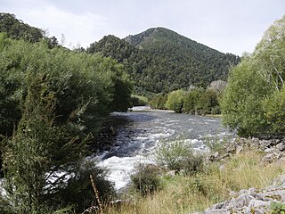
Te Kauparenui / Gowan River is in the South Island of New Zealand. Its source is at Lake Rotoroa and travels 11 kilometres before feeding into the Buller River. Mixed farming and forestry occurs on both banks of the river. The river has introduced trout which attracts recreational fishing.

The Waimakariri River is one of the largest rivers in Canterbury, on the eastern coast of New Zealand's South Island. It flows for 151 kilometres (94 mi) in a generally southeastward direction from the Southern Alps across the Canterbury Plains to the Pacific Ocean.
Carondelet Reef is a horseshoe-shaped reef, presumably a submerged atoll formation, of the Phoenix Islands, also known as the Rawaki Islands, in the Republic of Kiribati. It is located 106 kilometres southeast of Nikumaroro, at 05°34′S173°51′W, and has a least depth of 1.8 metres (5.9 ft). It is reported to be approximately 1.5 kilometres (0.9 mi) in length. The sea occasionally breaks over it.

The Anne River is a small river in Canterbury, New Zealand. It rises near the Anne Saddle and flows east then north for approximately 6 kilometres (4 mi) until it meets the Henry River, itself a tributary of the Waiau Uwha River. The St James Walkway, a popular tramping track, follows the Anne River for its entire length, and the Anne Huts are located near the river's mouth.
The Blue Grey River is a river in New Zealand. It is an upper tributary of the Grey River, flowing from Lake Christabel, close to the township of Maruia Springs, and flowing west for 8 kilometres (5 mi) before reaching the upper Grey River.

The Doubtful River is a river in the Canterbury region of New Zealand. It rises near Mount Barron and flows south then south-east through Lake Sumner Forest Park, reaching the Boyle River 40 kilometres (25 mi) west of Hanmer Springs. The Doubtful Range lies to the south. The Doubtless River and Devilskin Stream are tributaries entering from the north.

The Doubtless River is a river of northern Canterbury, New Zealand. A tributary of the Doubtful River, it rises south of Mount Boscawen and flows southward through the Lake Sumner Forest Park to join that river 2 kilometres (1.2 mi) east of Phantom Flat.
The Glencoe River is a river in the Canterbury region of New Zealand. It arises in the Organ Range near Shale Peak and flows south into the Mandamus River.
The Glenrae River is a river in the Canterbury region of New Zealand. It arises in the Glynn Wye Range near Mount Skiddaw and flows through the Lake Sumner Forest Park south and then south-east into the Hurunui River, which exits in the Pacific Ocean. Its tributaries include Devils Creek and Robyne Creek.
The Grantham River is a river in the Canterbury region of New Zealand. It arises in the Hanmer Range near Mount Miromiro, in the Hanmer Forest Park, and flows south-east into the Waiau Uwha River, which has its mouth on the Pacific Ocean.

The Hanmer River is a river in the Hurunui District of New Zealand. It originates in the Hossack Saddle between the Hanmer Range and the Amuri Range, and flows south-west into the Waiau Uwha River about 8 kilometres (5.0 mi) south-west of Hanmer Springs.
The Little Hohonu River is a river of New Zealand's West Coast Region. It flows northwest from its origins in the Hohonu Range southwest of Lake Brunner, reaching the Greenstone River / Hokonui 20 kilometres southeast of Greymouth.
The Morgan River is a river of the West Coast Region of New Zealand's South Island. It flows generally west from the small Lake Morgan, high in the Kaimata Range of the Southern Alps, reaching the Crooked River 18 kilometres (11 mi) from the latter's outflow into Lake Brunner.
The Otto River is a short river of the West Coast Region of New Zealand's South Island. It is one of the headwaters of the Grey River.
The Te Rahotaiepa River is a river of the West Coast Region of New Zealand's South Island. It rises to the north of Lake Ianthe and flows parallel with the Tasman Sea coast along the edge of marshy ground for several kilometres to flow into the mouth of the Waitaha River.
The Upper Grey River is a river of the West Coast Region of New Zealand's South Island. As the name suggests, it is a stretch of the Grey River, and the name is used for the section between the confluence of the Blue Grey River, Brown Grey River, and Crooked Mary Creek in the Southern Alps and the Upper Grey's confluence with the Little Grey River 25 kilometres southwest of Reefton.
The Waikiti River is a river of the West Coast Region of New Zealand's South Island. It flows generally north from it sources in the eastern Kaimata Range, roughly paralleling the course of its larger eastern neighbour, the Trent River. It reaches the Ahaura River 20 kilometres southeast of Lake Hochstetter.
The Warwick River is a river of the Tasman Region of New Zealand's South Island. It flows southwest to reach the Maruia River 10 kilometres north of Maruia. State Highway 65 follows the course of the Warwick River for some of its length.
Fry Glacier is a glacier draining the slopes at the northeast corner of the Convoy Range and flowing along the south end of the Kirkwood Range into Tripp Bay, Victoria Land, Antarctica. It was first charted by the British Antarctic Expedition, 1907–09, and named for A.M. Fry, a contributor to the expedition.
The Edwards River is a river located in the north of New Zealand's Canterbury region. It is the northern of the two rivers in New Zealand of this name.
References
- Land Information New Zealand - Search for Place Names
42°34′S172°38′E / 42.567°S 172.633°E