Related Research Articles

The Waimakariri River is one of the largest rivers in Canterbury, on the eastern coast of New Zealand's South Island. It flows for 151 kilometres (94 mi) in a generally southeastward direction from the Southern Alps across the Canterbury Plains to the Pacific Ocean.

Lake Sumner, known as Hoka Kura in Māori, is a highland lake situated 100 km (62 mi) northwest of Christchurch in the North Canterbury Region of New Zealand's South Island. Covering an area of 1,373 ha and a maximum depth of 135 m (443 ft), the lake is located in the Lake Sumner Forest Park and on the main stem of the Hurunui River. Several other lakes such as Loch Katrine, Lake Sheppard, Lake Taylor and Lake Mason also lie within the park.

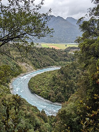
The Hurunui River is the fourth largest of the four principal rivers in north Canterbury, New Zealand, with a catchment area of 2,670 square kilometres (1,030 sq mi). The river flows from the eastern side of the Southern Alps, to the Pacific Ocean.
Mandamus River is a river in the South Island of New Zealand.
The Kaiwara River is a river of the northern South Island of New Zealand. The river is a tributary of the Hurunui River, its outflow being 17 kilometres (11 mi) southwest of Cheviot. The river flows initially east before turning southwest, twisting through a valley in the Lowry Peaks Range which lies between Cheviot and Culverden.
The Kaniere River is a river of New Zealand. It is located in the West Coast Region of the South Island. The river is the outflow of Lake Kaniere, and flows west to reach the Hokitika River five kilometres from the coast of the Tasman Sea.
The Little Hohonu River is a river of New Zealand's West Coast Region. It flows northwest from its origins in the Hohonu Range southwest of Lake Brunner, reaching the Greenstone River / Hokonui 20 kilometres southeast of Greymouth.
The Morgan River is a river of the West Coast Region of New Zealand's South Island. It flows generally west from the small Lake Morgan, high in the Kaimata Range of the Southern Alps, reaching the Crooked River 18 kilometres (11 mi) from the latter's outflow into Lake Brunner.
The Nancy River is a river of the West Coast Region of New Zealand's South Island. A tributary of the Ahaura River, it flows generally southwest from its source to the west of Mount Hochstsetter in the Southern Alps, turning west shortly before its outflow, 15 kilometres southeast of Lake Hochstetter.
The Rough River, alternatively known as the Otututu River is a river of the West Coast Region of New Zealand's South Island. A major tributary of the Grey River, it flows south from its sources near Mount Uriah in the Paparoa Range 20 kilometres southeast of Charleston, to reach the Grey River to the southwest of the settlement of Ikamatua. The river is currently shown on maps as Otututu (Rough) River, although this orthography is no longer common for New Zealand Rivers.
The Pahau River or Pahu River is a river of the north Canterbury region of New Zealand's South Island. It has its origins in the Tekoa Range, 25 kilometres (16 mi) northwest of Culverden, and flows initially north before turning south to flow down a long valley between two ridges. At the northern edge of the Canterbury Plains it turns southeast, flowing past the southern outskirts of Culverden to reach the Hurunui River 8 kilometres (5 mi) southeast of the town.

The Seaward River is a river in New Zealand's South Island. It flows northeast from its origins in north Canterbury's Puketeraki Range, reaching the Hurunui River 35 kilometres (22 mi) southwest of Culverden.
The Tass River is a river of the West Coast Region of New Zealand's South Island. It flows predominantly northeast from its origins in the Southern Alps east of Lake Hochstetter, reaching the Upper Grey River close to the southern tip of the Victoria Forest Park.

The Toaroha River is a river of the West Coast Region of New Zealand's South Island. It flows generally north through a valley between the Toaroha and Diedrichs Ranges to reach the Kokatahi River 25 kilometres southeast of Hokitika.

The Waiheke River is a river of the West Coast Region of New Zealand's South Island. It flows west from its origins on Mount Barron in the Southern Alps to reach the Ahaura River, which it forms where it joins the Tūtaekurī River, 20 kilometres northwest of Lake Sumner.
The Waikiti River is a river of the West Coast Region of New Zealand's South Island. It flows generally north from it sources in the eastern Kaimata Range, roughly paralleling the course of its larger eastern neighbour, the Trent River. It reaches the Ahaura River 20 kilometres southeast of Lake Hochstetter.
The Waitohi River is a river of the north Canterbury region of New Zealand's South Island. It initially flows northeast from its origins in the Puketeraki Range 25 kilometres (16 mi) south of Lake Sumner before turning eastwards to reach the Hurunui River at the settlement of Hurunui.
The Taipo River is a river of the central West Coast Region of New Zealand's South Island. It flows north from its sources west of Mount Rolleston, fed by the waters of several mountain streams. After some 15 kilometres it turns northeast to flow past the Bald Range before reaching the valley of the Taramakau River into which it flows 35 kilometres east of Hokitika.
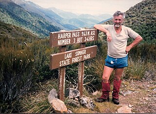
Harper Pass, previously known as Hurunui Pass or sometimes Taramakau Pass, is an alpine pass between Canterbury and the West Coast in New Zealand. It was the most important crossing for Māori to obtain pounamu. The first European crossed the pass in 1857 and the leader of the second party later that year, Leonard Harper, gave the pass its current name. It was of some interest to the settlers as the West Coast was part of Canterbury Province and it remained the only feasible route for some years. When the West Coast Gold Rush started in 1864, it became a heavily used crossing and remained so until October 1865, when a dray road over Arthur's Pass opened. The Arthur's Pass route was upgraded in March 1866 to coach traffic standard, and the much less direct route over Harper Pass fell out of use. It was restored in the 1930s as a tramping route and the Harper Pass Track, a four or five-day tramp, is today part of Te Araroa over its entire length.

The Butler Range, also known as North Butler Range, is a range located in the Westland District of the West Coast Region on the South Island of New Zealand. The range has also been known as Peaks of the Mist Range.
References
- ↑ "Place name detail: Hurunui River South Branch". New Zealand Gazetteer. New Zealand Geographic Board . Retrieved 19 December 2020.
- ↑ "Place name detail: Lake Mason". New Zealand Gazetteer. New Zealand Geographic Board . Retrieved 19 December 2020.
- ↑ "Place name detail: North Esk River". New Zealand Gazetteer. New Zealand Geographic Board . Retrieved 19 December 2020.
42°45′10.8″S171°56′24″E / 42.753000°S 171.94000°E