
Skiing in Victoria, Australia takes place in the Australian Alps located in the State of Victoria during the southern hemisphere winter. Victoria is the State with the greatest number of ski resorts in Australia. The highest peak in Victoria is Mount Bogong at 1986m. The first ski tow was constructed near Mount Buffalo in 1938. Victoria has a number of well developed ski resorts including Mount Hotham, Falls Creek and Mount Buller. Cross country skiing is popular in such national parks as Mount Buffalo National Park and Alpine National Park.

The Falls Creek Alpine Resort is an alpine ski resort in the Hume region in northeastern Victoria, Australia. It is located in the Alpine National Park in the Victorian Alps, approximately 350 kilometres by road from Melbourne, with the nearest town being Mount Beauty, which is approximately 30 km (20 mi) away. The resort lies between an elevation of 1,500 and 1,830 m above sea level, with the highest lifted point at 1,780 m (5,840 ft). Skiing is possible on the nearby peak of Mount McKay at 1,842 m (6,043 ft), accessed by snowcat from the resort.

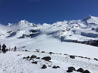
Whakapapa skifield is a commercial skifield on the northern side of Mount Ruapehu in Tongariro National Park, New Zealand. It is one of three skifields on the mountain, the others being Turoa, which is on Ruapehu's south-western slopes and Tukino on the eastern slopes. The ski season is generally from late June to late October, depending on snow and weather conditions. The terrain at Whakapapa Skifield is divided up as 25% beginner, 50% intermediate and 25% advanced.

Charlotte Pass is a snow resort and village in the Snowy Mountains of New South Wales, Australia. The pass is in the Kosciuszko National Park where the Kosciuszko Road crosses Kangaroo Ridge. Charlotte Pass is the closest village to Mount Kosciuszko, the tallest mountain in Australia.
Tukino skifield is located on the eastern face of Mount Ruapehu, in the central area of the North Island, New Zealand.

Perisher Valley, commonly called Perisher, is a valley formed below Mount Perisher, a mountain that is located in the Snowy Mountains of New South Wales, Australia.
Silver Star Mountain Resort is a ski resort located near Silver Star Provincial Park in the Shuswap Highland of the Monashee Mountains, 22 km northeast of the city of Vernon, British Columbia, Canada. Silver Star's snow season runs from late November to mid-April, weather permitting. Silver Star provides summer lift access for mountain biking and hiking from the end of June through September.

Mt. Baker Ski Area is a ski resort in the northwest United States, located in Whatcom County, Washington, at the end of State Route 542. The base elevation is at 3,500 feet (1,067 m), while the peak of the resort is at 5,089 feet (1,551 m). It is about ten miles (16 km) south of the 49th parallel, the international border with Canada. Despite its name, the Mt. Baker Ski Area is actually closer to Mount Shuksan than Mount Baker.

Snowbasin Resort is a ski resort in the western United States, located in Weber County, Utah, 33 miles (53 km) northeast of Salt Lake City, on the back (east) side of the Wasatch Range.

Mountain High resort is a winter resort in the San Gabriel Mountains in Los Angeles County in California. Mountain High is one of the most-visited resorts in Southern California. The resort is located along State Route 2 west of Wrightwood, California. The elevation of the resort is 6,600 feet (2,000 m) to 8,200 feet (2,500 m) for the Mountain High East Resort, 7,000 feet (2,100 m) to 8,000 feet (2,400 m) for the West Resort and 7,200 feet (2,200 m) to 7,800 ft (2,400 m) for the North Resort.

Banff Sunshine Village is a ski resort in western Canada, located on the Continental Divide of the Canadian Rockies within Banff National Park in Alberta and Mount Assiniboine Provincial Park in British Columbia. It is one of three major ski resorts located in the Banff National Park. Because of its location straddling the Continental Divide, Sunshine receives more snow than the neighbouring ski resorts. The Sunshine base area is located 15 km (9 mi) southwest of the town of Banff. By car, it is about a ninety-minute drive from the city of Calgary; the Sunshine exit on the Trans Canada Highway is 8 km (5 mi) west of the town of Banff.

Mount Hood Skibowl is a recreation area on Mount Hood located near Government Camp, Oregon. It is the largest night ski area in the United States, and the total skiable area encompasses an area of 960 acres (388 ha). The resort is the closest ski venue to Portland, with an elevation of 3,600 feet (1,097 m) at the lodge, rising to just over 5,000 feet (1,524 m) at the summit. The average snowfall at the area is 300 inches (762 cm), with an average consolidated base around 100 inches (254 cm) and 65 marked trails. An adventure park in the area includes alpine slides, zip-line, and bungee jumping. As well as other outdoor activities. Just across the highway is Government Camp, the focal point of Mount Hood.
Brundage Mountain Resort is an alpine ski area in the western United States, located in west central Idaho in the Payette National Forest. Brundage first opened in November 1961 and is eight miles (13 km) northwest of McCall, a twenty-minute drive in average winter conditions.
Mount Waterman is a ski area on Waterman Mountain in the San Gabriel Mountains of the Angeles National Forest in Los Angeles County, California. The area is located on California State Route 2, the Angeles Crest Highway, and reaches a height of 8,030 ft (2,450 m) with an overall vertical drop of 1,030 ft (310 m). Mount Waterman is leased under a special use permit from the United States Forest Service. Skiable terrain is distributed as: 20% beginner, 20% intermediate, and 60% advanced.
Hanmer Springs Ski Area, located on Mount Saint Patrick, South Island, New Zealand is a club skifield 17 km from the town of Hanmer Springs. It has New Zealands longest Poma lift at over 800m, a nutcracker rope tow and a new beginners fixed grip rope tow, giving access to trails rated as 10% beginner, 60% intermediate and 30% advanced. Elevation is 1769m at the top of the field with 52ha of ski terrain.

The Awakino ski field is located in St. Marys Range, in the Canterbury, New Zealand part of Waitaki District near Kurow. It is run by the Waitaki Ski Club. The field is little changed from when it was established in the late 1940s. Run by volunteers only, it operates most weekends in the winter season, which normally lasts from July to October. The field has one and a half high-speed rope tows, queues are unheard of and a busy day means more than 10 people.
The Kahutara River is a river of New Zealand's South Island. It flows southeast from the Seaward Kaikōura Range, reaching the Pacific Ocean at the tiny settlement of Peketā, 7 kilometres (4 mi) southwest of Kaikōura.

Skiing in Australia takes place in the Australian Alps in the states of New South Wales, Victoria and the Australian Capital Territory as well as in the mountains of the island state Tasmania, during the Southern Hemisphere winter.

Perisher Ski Resort is the largest ski resort in the Southern Hemisphere. Located in the Australian Snowy Mountains, the resort is an amalgamation of four villages and their associated ski fields, covering approximately 12 square kilometres (5 sq mi), with the base elevation at 1,720 metres (5,640 ft) AHD, and the summit elevation of 2,054 metres (6,739 ft) at the top of Mount Perisher. 4.4 square kilometres (1.7 sq mi) of this area is covered by 240 snow guns, which are used to artificially supplement the natural snowfall. Perisher was acquired by Vail Resorts, United States on 30 March 2015 for a sum of approximately AU$177 million.
The Inland Kaikōura Road, formerly designated State Highway 70, is a provincial highway in the South Island of New Zealand that runs from just south of Kaikōura to just north of Culverden via Waiau and Rotherham. White shields are used to signify this highway. It forms part of the Alpine Pacific Triangle tourist route. It also serves as an alternative inland route in cases where SH 1 is closed near the South Kaikōura Coast. Following the 14 November 2016 Kaikōura earthquake, all roads into Kaikōura were closed including SH70; after extensive regrading and clearance the Inland Road was the first road connection to Kaikōura to reopen and was a lifeline for the community.
