Craigieburn Valley Ski Area

Last updated
Craigieburn Valley Ski Area

Craigieburn valley.jpg

Looking up the valley
Location Canterbury NZ
Nearest city Springfield
Coordinates 43°07′08″S171°41′50″E / 43.1188°S 171.6971°E / -43.1188; 171.6971 Coordinates: 43°07′08″S171°41′50″E / 43.1188°S 171.6971°E / -43.1188; 171.6971
Top elevation 1922 m [1]
Base elevation 1308 m [1]
Skiable area 400 hectare [1]
Runs Backcountry
Lift system 3 Rope tow [1]
Terrain parks 0
Snowmaking no
Night skiing On a full moon [2]
Website http://www.craigieburn.co.nz

Craigieburn Valley Ski Area is a club skifield in the Southern Alps of New Zealand's South Island, about 104km west from Christchurch. [3] Catering only to intermediate and advanced skiers, it features a vertical range of 1308—1811 m, 600 hectares of skiable area and 3 fast rope tows. The resort has several ski lodges but no gear hire. [1] It is also the base for ski touring expeditions when conditions permit. It is immediately adjacent to the Broken River Ski Area, with which it shares a ski pass system. Skiing between the two is possible with some skinning involved. [3]

In New Zealand, a club skifield is a small ski resort run by a ski club to provide affordable skiing to its members. While members of the public can ski, members of the club receive heavily discounted rates, in exchange for a yearly membership fee and usually several days of voluntary work maintaining the resort.

New Zealand Constitutional monarchy in Oceania

New Zealand is a sovereign island country in the southwestern Pacific Ocean. The country geographically comprises two main landmasses—the North Island, and the South Island —and around 600 smaller islands. New Zealand is situated some 2,000 kilometres (1,200 mi) east of Australia across the Tasman Sea and roughly 1,000 kilometres (600 mi) south of the Pacific island areas of New Caledonia, Fiji, and Tonga. Because of its remoteness, it was one of the last lands to be settled by humans. During its long period of isolation, New Zealand developed a distinct biodiversity of animal, fungal, and plant life. The country's varied topography and its sharp mountain peaks, such as the Southern Alps, owe much to the tectonic uplift of land and volcanic eruptions. New Zealand's capital city is Wellington, while its most populous city is Auckland.

South Island Southernmost of the two main islands in New Zealand

The South Island, also officially named Te Waipounamu, is the larger of the two major islands of New Zealand in surface area; the other being the smaller but more populous North Island. It is bordered to the north by Cook Strait, to the west by the Tasman Sea, and to the south and east by the Pacific Ocean. The South Island covers 150,437 square kilometres (58,084 sq mi), making it the world's 12th-largest island. It has a temperate climate.

The Whakamaru Day Lodge Craigieburn daylodge.jpg
The Whakamaru Day Lodge

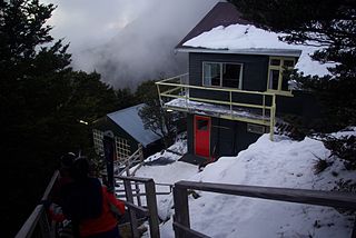
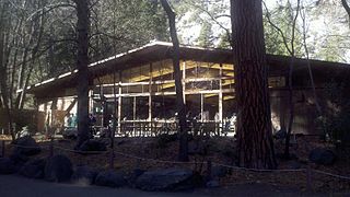
Craigieburn has two accommodation lodges, the main Koroheke lodge which has 6-bed dorm rooms and Matuhi which has private rooms. Through the winter there are many ski and accommodation package options as well as a ski week system, where people come and stay for a Sunday to Saturday week. Duties are shared between staff and guests and, while there is a cook and a manager, light duties are normally done by guests. This is the nature of most club fields in New Zealand. There is also a bar in Koroheke lodge, the normal meeting place after a day on the field. [4] The services available during the day are at the day lodge located near the top of the mountain. There you can find hot food options and fresh coffee, and it is a warm spot to stop off with a great view of the ski area.

On the way to Hamilton Peak from Craigieburn Valley Hamiltonpeak.jpg
On the way to Hamilton Peak from Craigieburn Valley

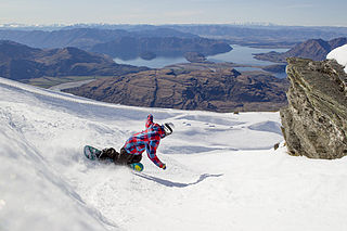
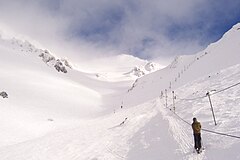
Craigieburn is internationally famous for its steep terrain, 45% rated as advanced. There is no grooming and the hiking and ski touring options are excellent, including Middle Basin, a 600m open bowl back to the access road, commonly compared to heli-skiing. [3] Hamilton Peak is a popular spot, giving the skier access to the upper Hamilton face. The trip to the Broken River ski field lift system can be accomplished from Hamilton Peak without any further ascent. There are also many back-country and touring options past Middle Basin into North Middle, True North basins and Mt Manson.

Related Research Articles

Whakapapa skifield skifield

Whakapapa, on the northern side of Mount Ruapehu in New Zealand's Tongariro National Park, is one of the mountain's two commercial ski fields. The other is Turoa, located on the mountain's south-western slopes. The ski season is generally from late June to late October, depending on snow and weather conditions. Turoa has a slightly longer season, generally opening a week before Whakapapa and closing early November. The terrain at Whakapapa Skifield is divided up as 25% beginner, 50% intermediate and 25% advanced. Access to the skifield is by Bruce Road, a 2-lane, 6 km sealed road. Limited accommodation and refreshments are available at 'Top o' the Bruce', at the entry to the skifield, and elsewhere on the mountain. Alpine huts are provided for trampers and climbers.

Treble Cone

Treble Cone is the closest ski area to Wanaka, New Zealand.

Snowbird, Utah unincorporated community in Salt Lake County, Utah, United States

Snowbird is an unincorporated community in Little Cottonwood Canyon in the Wasatch Range of the Rocky Mountains near Salt Lake City, Utah, U.S. It is most famous for Snowbird Ski and Summer Resort, an alpine skiing and snowboarding area, which opened in December 1971.

Alta Ski Area

Alta is a ski area in the western United States, located in the town of Alta in the Wasatch Mountains of Utah, in Salt Lake County. With a skiable area of 2,614 acres (10.58 km2), Alta's base elevation is 8,530 ft (2,600 m) and rises to 11,068 ft (3,374 m) for a vertical gain of 2,538 ft (774 m). One of the oldest ski resorts in the country, it opened its first lift in early 1939. Alta is known for being very high altitude and receives more snow than most Utah resorts, its average annual snowfall is 545 inches (13.8 m). Alta is one of three remaining ski resorts in the U.S. that prohibits snowboarders, along with nearby competitor Deer Valley and Vermont's Mad River Glen.

Serfaus Place in Tyrol, Austria

Serfaus is a municipality in the district of Landeck in the Austrian state of Tyrol. It is well known as part of the ski-region "Serfaus-Fiss-Ladis", which was formed when Serfaus teamed up with the two nearby municipalities of Fiss and Ladis in 1999. Serfaus is also known for its small hovertrain subway system, the Dorfbahn Serfaus. With four stations and a length of 1280 m it allows for a complete ban of cars within the town, while at the same time maintaining the village's attractiveness to tourists, particularly skiers.

Ohau (skifield)

Ohau is a small commercial skifield in the foothills of New Zealand's Southern Alps, near the boundary between the Otago and Canterbury regions, and close to the southwestern shore of the lake of the same name. The skifield was originally developed by the Mount Cook and Southern Lakes Tourist Co.

Perisher Valley, New South Wales human settlement in Australia

Perisher Valley, commonly called Perisher, is a valley formed below Mount Perisher, a mountain that is located in the Snowy Mountains of New South Wales, Australia.

Sugarbush Resort

Sugarbush Resort is a ski resort located in the Mad River valley in Warren, Vermont. It is one of the largest ski resorts in New England. The resort encompasses more than 4000 acres (16 km²) total, 484 trail acres (2.34 km²) skiable, 53 miles (85 km) of trails, and 16 ski lifts. Sugarbush has 111 ski trails, 18 additional marked wooded area, substantial off-piste skiing and riding, a summit elevation of 4,083 ft (1,244 m), and a vertical drop of 2,600 feet (790 m), second largest in Vermont after Killington, and the third largest in New England after Killington and Sugarloaf.

Mount Assiniboine Provincial Park provincial park in British Columbia, Canada

Mount Assiniboine Provincial Park is a provincial park in British Columbia, Canada, located around Mount Assiniboine.

Broken River Ski Area

Broken River is a club skifield in South Island, New Zealand. Run by the Broken River Ski Club, it is located at about 110 km (68 mi) from Christchurch. The skifield claims to often have the longest ski season anywhere in Australasia. Also, by connecting with Craigieburn Valley, it claims to have the largest skiable area in New Zealand, at 900 hectares.

Porters Ski Area

Porters, is a commercial ski resort just over an hour's drive west from Christchurch, in the South Island of New Zealand. Originally functioning as a club skifield, it has one beginner magic carpet, one platter tow, one chairlift and three t-bars. The difficulty of the slopes is distributed as 15% beginner, 35% intermediate and 50% advanced. Modern grooming equipment is used, and snowmaking facilities operate along the main pistes along the chairlift.

Snow Farm, New Zealand

Snow Farm is a ski area near Wanaka, New Zealand, dedicated to cross-country skiing. It features 55 km of trails, and the conference centre has accommodation for about 60 people. It is located on the Pisa range close to Cardrona, at an altitude of approx 1,600 m. The area is used for cross country skiing in the winter and during the summer months for altitude training with trails climbing out to 2000m. The proximity of Wanaka (275m) and Queenstown (310m) and the training options around these two towns makes the Snow Farm one of the best locations in the Southern Hemisphere for a live high, train low training regime.

Temple Basin

Temple Basin is a club skifield in Arthur's Pass, in New Zealand's South Island. Operated by two clubs, the Temple Basin Ski Club, and the Canterbury University Snow Sports Club, the ski area has 3 rope tows, two on-site lodges, two shelters and a ski school and ski shop. The tows cover an elevation range of 1326–1753 metres, for a skiable domain of 320 hectares. Its natural terrain has been highly recommended by adventure skiers on several occasions.

The Craigieburn Range forms part of the Southern Alps in New Zealand's South Island. The range is located on the south banks of the Waimakariri River, south of Arthur's Pass and west of State Highway 73. The Craigieburn locality is adjacent to the Craigieburn Forest Park.

Island Lake Lodge and catskiing is a back country resort located on 7,000 acres (28 km2) of mountainous terrain near Fernie B.C. Canada. Island Lake Lodge is situated in Fernie, British Columbia, Canada just beyond the Mount Fernie Provincial Park.

Yosemite Valley Lodge

The Yosemite Valley Lodge is a lodging accommodation, in western Yosemite Village, Yosemite Valley, Yosemite National Park, Mariposa County, California, located at 9006 Yosemite Lodge Drive.

Perisher Ski Resort ski resort in New South Wales, Australia

Perisher is the largest ski resort in the Southern Hemisphere. Located in the Australian Snowy Mountains, the resort is an amalgamation of four villages and their associated ski fields, covering approximately 12 square kilometres (5 sq mi), with the base elevation at 1,720 metres (5,640 ft) AHD, and the summit elevation of 2,054 metres (6,739 ft) at the top of Mount Perisher. 4.4 square kilometres (1.7 sq mi) of this area is covered by 240 snow guns, which are used to artificially supplement the natural snowfall. Perisher was acquired by Vail Resorts, United States on March 30, 2015 for a sum of approximately AU$177 million.

References

  1. 1 2 3 4 5 Craigieburn Valley Ski Area Archived 2007-05-17 at the Wayback Machine .General Info, Accessed 21/1/7
  2. Chill. Multi Mountain Pass Craigieburn, Ski the Big One Accessed 19/5/7
  3. 1 2 3 Guide to New Zealand ski fields Archived 2007-07-06 at the Wayback Machine ., Craigieburn, Accessed 3/5/07
  4. Craigieburn Valley Ski Area Archived 2007-05-18 at the Wayback Machine .Accommodation, Accessed 21/1/7