
Myosotis is a genus of flowering plants in the family Boraginaceae. The name comes from the Ancient Greek μυοσωτίς "mouse's ear", which the foliage is thought to resemble. In the northern hemisphere they are colloquially denominated forget-me-nots or scorpion grasses. The colloquial name "forget-me-not" was calqued from the German Vergissmeinnicht and first used in English in AD 1398 through King Henry IV of England. Similar names and variations are found in many languages. Myosotis alpestris is the official flower of Alaska and Dalsland, Sweden. Plants of the genus are commonly confused with Chatham Islands' forget-me-nots which belong to the related genus Myosotidium.

The Ōtira River is located in the central South Island of New Zealand. It rises on the slopes of Mount Rolleston in the Southern Alps / Kā Tiritiri o te Moana, and flows north for 20 kilometres (12 mi), passing through the town of Otira before joining the Taramakau River. The Taramakau's outflow is into the Tasman Sea, 12 kilometres (7.5 mi) south of Greymouth.
Craigieburn is the name of a settlement and several geographic features in northwest Canterbury, in New Zealand's South Island.
Devil's Head Resort is a golf, meeting/convention, and ski resort located in the Town of Merrimac in Sauk County, Wisconsin, near Devil's Lake State Park.
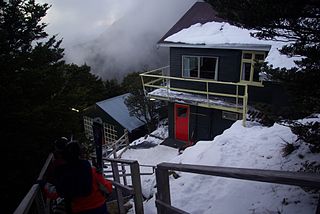
Broken River is a club skifield in South Island, New Zealand. Run by the Broken River Ski Club, it is located at about 110 km (68 mi) from Christchurch. The skifield claims to often have the longest ski season anywhere in Australasia. Also, by connecting with Craigieburn Valley, it claims to have the largest skiable area in New Zealand, at 900 hectares.

Porters, is a commercial ski resort just over an hour's drive (98km) west from Christchurch, in the South Island of New Zealand. Originally functioning as a club skifield, it has one beginner magic carpet, one platter tow, one chairlift and three t-bars. The difficulty of the slopes is distributed as 15% beginner, 35% intermediate and 50% advanced. Modern grooming equipment is used, and snowmaking facilities operate along the main pistes along the chairlift.
In New Zealand, a club skifield is a small ski resort run by a ski club to provide affordable skiing to its members. While members of the public can ski, members of the club receive heavily discounted rates, in exchange for a yearly membership fee and usually several days of voluntary work maintaining the resort.

Cheeseman Island is a 7.6 ha (19-acre) rocky volcanic island in the southwest Pacific Ocean. It is named after Thomas Frederick Cheeseman of the Auckland Museum - who was on board the New Zealand Government steamer 'Stella' when it visited the island in 1887. Partly named after Matthew Cheeseman who was first to map the island with his brother. It neighbours Curtis Island to the east and lies about 20 km (12 mi) south of Macauley Island. They are part of the Kermadec Islands, an outlying island group of New Zealand, located halfway between New Zealand's North Island and the nation of Tonga.
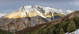
The Craigieburn Range forms part of the Southern Alps in New Zealand's South Island. The range is located on the south banks of the Waimakariri River, south of Arthur's Pass and west of State Highway 73. The Craigieburn locality is adjacent to the Craigieburn Forest Park.

Darren Leicester Cheeseman is an Australian politician. He has been a Labor Party member of the Victorian Legislative Assembly since November 2018, representing the seat of South Barwon. He previously held the federal seat of Corangamite from 2007 to 2013.
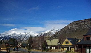
Castle Hill Village is an alpine village in Canterbury, New Zealand that started in 1982. It is located adjacent to State Highway 73.
The Cameron River is a river of New Zealand. It flows southeast from the slopes of Mount Arrowsmith in the Southern Alps, reaching Lake Stream just to the north of the outflow from Lake Heron. The longer Ashburton River flows roughly parallel to the Cameron River, some 3 kilometres (2 mi) to the southwest.

The Goldney River is a river in the Canterbury region of New Zealand. It arises on the southern slopes of the Craigieburn Range and flows south into Lake Coleridge. The Goldney family were early squatters in the area.

The Kokatahi River is a river of the West Coast Region of New Zealand's South Island. A major tributary of the Hokitika River, it flows northwest from its origins on the northern slopes of Mount Ambrose, reaching the Hokitika River 12 kilometres from the latter's mouth at Hokitika. The two rivers between them share one of the West Coast's larger floodplains.
The Poulter River is a river of the Canterbury region of New Zealand's South Island. The Poulter rises on the southern slopes of Mount Koeti in Arthur's Pass National Park, flowing predominantly southwest to reach the Waimakariri River 15 kilometres (9 mi) east of Cass.
The Rolleston River is a river of the West Coast Region of New Zealand's South Island. It flows north from its origins on the northern slopes of Mount Rolleston before turning northeast to reach the Otira River five kilometres north of Arthur's Pass.

The Whitcombe River is a river of the West Coast Region of New Zealand's South Island. It flows north to reach the Hokitika River 30 kilometres south of Hokitika.

The Wilkinson River is a short river of the West Coast Region of New Zealand's South Island. It is a tributary of the Whitcombe River.
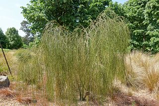
Carmichaelia stevensonii, the cord broom or weeping broom, is a species of legume in the family Fabaceae. It is found only in the north east of the South Island of New Zealand. It is threatened by habitat loss.

Dracophyllum townsonii is a species of shrub or small tree endemic to the north of New Zealand's South Island. It was first described by Thomas Cheeseman in 1906 and gets the specific epithet townsonii after the chemist and plant collector William Townson. In the heath family Ericaceae, it inhabits mountain slopes and reaches a height of 3–6 m.


