Gore Bay, New Zealand

Last updated

Houses in Gore Bay Gore Bay Houses 005.JPG
Houses in Gore Bay
1874 watercolour painting, with Mrs Robinson's cottage behind the cabbage tree Gore Bay, 1874.jpg
1874 watercolour painting, with Mrs Robinson's cottage behind the cabbage tree

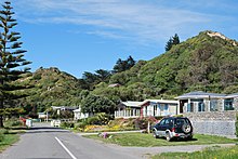
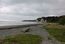
Gore Bay is a coastal settlement about 8 kilometres (5 mi) from Cheviot, New Zealand.

Contents

It has a surfing beach with summer beach houses and 14 permanent residents. There are two local camping grounds, each with beach access and business. It is a popular New Year's Eve venue.[ citation needed ] Of note is Cathedral Gully, a spectacular weathered clay canyon.

Gore Bay Gore Bay 27.jpg
Gore Bay

The cottage at 60 Moody Street that once belonged to Mrs. Eliza Robinson, wife of local runholder William 'Ready Money' Robinson, is registered by Heritage New Zealand as a Category II structure, with registration number 1769. [1]

Toponymy

The Maori name for this place is Pāua pirau meaning decayed pāua . [2]

The place name Gore Bay is not an official name but is a recorded name that is probably derived from Gore's Bay shown on Captain Cook's map of New Zealand as the bay between Banks Island and the southern island, T’avai Poenammoo. [3]

Climate

Climate data for Gore Bay
MonthJanFebMarAprMayJunJulAugSepOctNovDecYear
Average precipitation mm (inches)61.7
(2.43)
57.1
(2.25)
78.4
(3.09)
80.9
(3.19)
82.4
(3.24)
69
(2.7)
81.1
(3.19)
79
(3.1)
53
(2.1)
61.4
(2.42)
64.4
(2.54)
51.8
(2.04)
820.2
(32.29)
Source: Climate Charts [4]

Related Research Articles

<span class="mw-page-title-main">Riverton / Aparima</span> Town in the South Island of New Zealand

Riverton, officially Riverton / Aparima, is a small New Zealand town 30 kilometres (19 mi) west of Invercargill, on the south-eastern shorelines of the Jacobs River Estuary. The estuary is formed by the Aparima and Pourakino rivers, leading through a narrow outflow channel into Foveaux Strait. Accessible via State Highway 99 on the Southern Scenic Route, the main part of the town is on flat land and the northern end of Oreti Beach. South Riverton is built on the hills between the eastern shore of the estuary and Taramea Bay.

<span class="mw-page-title-main">Russell, New Zealand</span> Town in the Northland Region of New Zealand

Russell, sometimes referred to as Kororāreka, is a town in the Bay of Islands, in New Zealand's far north. It was the first permanent European settlement and seaport in New Zealand. In January 2023, the New Zealand Geographic Board Ngā Pau Taunaha o Aotearoa proposed that the town's name be officially changed back to Kororāreka, its original Māori name.

Dual naming is the adoption of an official place name that combines two earlier names, or uses both names, often to resolve a disagreement over which of the two individual names is more appropriate. In some cases, the reasons are political. Sometimes the two individual names are from different languages; in some cases this is because the country has more than one official language, and in others, one language has displaced another.

<span class="mw-page-title-main">Lyttelton Harbour</span> Inlet on Banks Peninsula, New Zealand

Lyttelton Harbour / Whakaraupō is a major inlet on the northwest side of Banks Peninsula, on the coast of Canterbury, New Zealand; the other major inlet is Akaroa Harbour, which enters from the southern side of the peninsula. Whakaraupō enters from the northern coast of the peninsula, heading in a predominantly westerly direction for approximately 15 km (9.3 mi) from its mouth to the aptly-named Head of the Bay near Teddington. The harbour sits in an eroded caldera of the ancient Banks Peninsula Volcano, the steep sides of which form the Port Hills on its northern shore.

Colac Bay / Ōraka is a small township situated on the bay of the same name facing Foveaux Strait, and located on the Southern Scenic Route, 10 minutes from Riverton, New Zealand. Surrounding areas include Longwood, Tihaka, Waipango, Round Hill, Wakapatu, Ruahine, Pahia and Orepuki.

<span class="mw-page-title-main">Stanley Point</span> Suburb in Auckland, New Zealand

Stanley Point is a small suburb located on the North Shore of Auckland, New Zealand. It is located near Devonport, another suburb. It is mostly residential. The Devonport Naval Base lies to the east of the bay on the south side of the Stanley Bay peninsula and is connected to storage facilities on the north side at Ngataringa Bay by a tunnel.

Parkdale is a mainly residential subdivision in the suburb of Birchville in Upper Hutt, New Zealand. It is located north of the Upper Hutt city centre on the northern side of Emerald Hill nestled between Birchville, Te Mārua, Timberlea and Brown Owl.

<span class="mw-page-title-main">New Zealand place names</span> Overview of place names in New Zealand

Most New Zealand place names have a Māori or a British origin. Both groups used names to commemorate notable people, events, places from their homeland, and their ships, or to describe the surrounding area. It is unknown whether Māori had a name for the whole of New Zealand before the arrival of Europeans, but post-colonisation the name Aotearoa has been used to refer to the whole country. Dutch cartographers named the islands Nova Zeelandia, the Latin translation of the Dutch Nieuw Zeeland. By the time of British exploration, the country's name was anglicised to New Zealand.

The New Zealand Geographic Board Ngā Pou Taunaha o Aotearoa (NZGB) was established by the New Zealand Geographic Board Act 1946, which has since been replaced by the New Zealand Geographic Board Act 2008. Although an independent institution, it is responsible to the Minister for Land Information.

<span class="mw-page-title-main">Rapanui Rock</span>

Shag Rock, also known as Rapanui, is a notable sea stack that marks the entrance of the Avon Heathcote Estuary near Christchurch, New Zealand. It is a prominent landmark for navigators at sea as well as travelers on the road to Sumner. The rock stands close to the southern shore just above the low tide level. In the February 2011 Christchurch earthquake it shattered and the remains, which are still easily seen from the road, have, with dark humour by some locals, been called "Shag Pile".

<span class="mw-page-title-main">Purakaunui River</span> River in New Zealand

The Purakaunui River is a river in the western Catlins, New Zealand. It rises west of Houipapa and flows through the Pūrākaunui Bay Scenic Reserve into the Pacific Ocean at Pūrākaunui Bay. The river is best known for Purakaunui Falls.

<span class="mw-page-title-main">Taukihepa / Big South Cape Island</span>

Big South Cape Island or Taukihepa is an offshore island of New Zealand to the west of the southern tip of Stewart Island / Rakiura. The island has no permanent inhabitants but muttonbirders visit the island to catch the sooty shearwater, known in New Zealand as a "muttonbird".

<span class="mw-page-title-main">Ōhau River (Canterbury)</span> River in the South Island of New Zealand

The Ōhau River is a short river, some 8 kilometres (5 mi) long, that links Lake Ōhau with the artificial lake Ruataniwha in the Mackenzie Basin, New Zealand.

The Ōhau River is in the Horowhenua District of New Zealand's North Island. It flows from the confluence of two short rivers, the North Ōhau River and the South Ōhau River. The Ōhau initially flows north, turning west to the southeast of Levin. It reaches the Tasman Sea 10 kilometres (6 mi) southwest of Levin.

Otago Glacier is a glacier about 20 nautical miles (37 km) long draining the northeast side of Mount Markham and entering Nimrod Glacier just east of Svaton Peaks. Named by the northern party of the New Zealand Geological Survey Antarctic Expedition (NZGSAE) (1961–62) for the University of Otago, New Zealand.

<span class="mw-page-title-main">Hillpark, Auckland</span> Suburb of Auckland, New Zealand

Hillpark is a suburb in Auckland, New Zealand. It is bordered by suburbs of The Gardens on the east and Manurewa on the south. It was formerly part of Manukau City until the 2010 amalgamation of all of Auckland's councils, and is now under the governance of Auckland Council.

<span class="mw-page-title-main">Pōhara</span> Settlement in Tasman, New Zealand

Pōhara is a rural locality in the Tasman District of New Zealand's South Island. The locality is northeast of Tākaka and southwest of Tata Beach. To the north is Limestone Bay, part of Golden Bay / Mohua

References

  1. "Cottage (for Mrs 'Ready Money' Robinson)". New Zealand Heritage List/Rārangi Kōrero. Heritage New Zealand . Retrieved 17 August 2012.
  2. "Map of Te Wai Pounamu NZMS 346/2". NZGB place name maps and publications. New Zealand Geographic Board Ngā Pou Taunaha o Aotearoa. Retrieved 11 January 2021.
  3. "Gore Bay". NZGB Gazetteer. New Zealand Geographic Board Ngā Pou Taunaha o Aotearoa. Retrieved 11 January 2021.
  4. "Gore Bay, New Zealand Climate, Global Warming, and Daylight Charts and Data". Climate Charts. Retrieved 2 September 2013.

42°51′31.3″S173°18′34.3″E / 42.858694°S 173.309528°E / -42.858694; 173.309528