
Molesworth Station is a high country cattle station. It is located behind the Inland Kaikōura Mountain range in the South Island's Marlborough District. It is New Zealand's largest farm, at over 1,800 square kilometres and supports the country's biggest herd of cattle. It also hosts government science programs, such as research into bovine tuberculosis and related research into possums. The station helps rabbit population reduction.
Clarence is a small town in Canterbury, in the South Island of New Zealand. It was named after King William IV of the United Kingdom, who prior to his accession was Duke of Clarence.

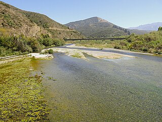
The Clarence River is a major river which flows through the Kaikōura Ranges in the northeast of New Zealand's South Island. At roughly 209 kilometres (130 mi) long, it is the longest river in Canterbury and the eighth longest in New Zealand.

The Kaikōura Ranges are two parallel ranges of mountains located in the northeast of the South Island of New Zealand. The two ranges are visible from a great distance, including from the southern coast of the North Island.

Ward is a small town in Marlborough, New Zealand. It is located on State Highway 1, 82 kilometres (51 mi) north of Kaikōura. The Flaxbourne River flows past to the north and into the Pacific Ocean at Ward Beach to the south-east of Ward. A current initiative aims to have the town renamed as Flaxbourne.
The Hundalee Hills are located close to the borders of Hurunui District and Kaikōura District in Canterbury in the South Island of New Zealand.
The Charwell River is a river in the northeast of New Zealand's South Island. Its headwaters are in the Seaward Kaikōura Ranges and it feeds into the Conway River, the traditional boundary between Marlborough and Canterbury. Sheep farming has taken place in the Charwell River's valley.
The Bluff River is a river of New Zealand. It is in the Canterbury Region and is a tributary of the Waiau Toa / Clarence River. The Bluff River flows south for 10 kilometres (6 mi) from the slopes of Mount Major in the Inland Kaikōura Range. Confusingly, the Bluff Stream, another tributary of the Waiau Toa / Clarence, follows a largely parallel course 5 kilometres (3 mi) to the east.
The Dillon River is a river of the Marlborough Region of New Zealand. It arises in the Inland Kaikōura Range near Carters Saddle, and flows south-west for 28 kilometres (17 mi) to join with the upper Waiau Toa / Clarence River 20 kilometres (12 mi) northeast of Hanmer Springs. The river's course lies largely parallel with that of the Acheron River, which lies 8 kilometres (5 mi) to the west. The river was named after Constantine Dillon, who owned a sheep run near the Omaka River.
The Eastern Hohonu River is a river of New Zealand. It rises in the Hohonu Range, an outlying range of the Southern Alps 28 kilometres southeast of Greymouth, flowing north then east before reaching its outflow into Lake Brunner. It is named the Eastern Hohonu River to differentiate it from the nearby Big Hohonu River, which is also called the Greenstone River.
The Gloster River is a river in the Marlborough region of New Zealand. It arises on the northern slope of Dillon Cone in the Inland Kaikōura Range and flows north, then south-east and east to join the Waiau Toa / Clarence River which eventually exits into the Pacific Ocean.
The Greta River is a river in the Hurunui District of New Zealand. It flows north-east into the Hurunui River, which runs into the Pacific Ocean south of Cheviot, New Zealand. State Highway 1 follows the river for part of its route between Cheviot and Waipara. The locality of Greta Valley is to the east of the Greta River on the banks of the Waikari River. The river was named by local runholders Sir Charles Clifford and Sir Frederick Weld in the 1850s after the Greta River in Yorkshire.
The Kahutara River is a river of New Zealand's South Island. It flows southeast from the Seaward Kaikōura Range, reaching the Pacific Ocean at the tiny settlement of Peketā, 7 kilometres (4 mi) southwest of Kaikōura.

The Oaro River is a river of the north Canterbury region of New Zealand's South Island. It flows south from its sources in the Hundalee Hills, turning east shortly before reaching the coast at Oaro, 15 kilometres (9 mi) southwest of Kaikōura.
The Tone River is a river of the Marlborough Region of New Zealand's South Island. It flows generally north from its sources in the Inland Kaikoura Range to reach the Awatere River 17 kilometres (11 mi) northeast of Molesworth Station.
The Waimangarara River is a river of the Marlborough Region of New Zealand's South Island. It flows generally south from its origins in the Seaward Kaikōura Range to reach the Pacific Ocean 5 kilometres (3 mi) north of Kaikōura.
The Gelt River is a river in the Canterbury region of New Zealand. It arises near Mount Peter in the Black Hills and flows south, then east and north-east into Conway River.

The Kowhai Valley and Shearwater Stream Important Bird Area comprises a disjunct site in the Seaward Kaikōura Range in the north-east of New Zealand's South Island, some 15 km (9.3 mi) inland from the coastal town of Kaikōura. The site, at an altitude of 1,200–1,800 m (3,900–5,900 ft) above sea level, has been identified as an Important Bird Area by BirdLife International because it contains the entire breeding population of Hutton's shearwaters; about 100,000 pairs in two colonies.

Kaikōura District Council is the territorial authority for the Kaikōura District of New Zealand.
The Kaikōura Canyon is a geologically active submarine canyon located southwest of the Kaikōura Peninsula off the northeastern coast of the South Island of New Zealand. It is 60 kilometres (37 mi) long, and is generally U-shaped. The canyon descends into deep water and merges into an ocean channel system that can be traced for hundreds of kilometres across the deep ocean floor. At the head of the Kaikōura Canyon, the depth of water is around 30 metres (98 ft), but it drops rapidly to 600 metres (2,000 ft) and continues down to around 2,000 metres (6,600 ft) deep where it meets the Hikurangi Channel. Sperm whales can be seen close to the coast south of Goose Bay, because the deep water of the Kaikōura Canyon is only one kilometre (0.62 mi) off the shoreline in this area.
