North Corktown, Detroit

Last updated
North Corktown
Motor City Casino Length.png
Motor City Casino in North Corktown
Wayne County Michigan Incorporated and Unincorporated areas Detroit highlighted.svg
Red pog.svg
Location within the city of Detroit
USA Michigan location map.svg
Red pog.svg
North Corktown, Detroit (Michigan)
Coordinates: 42°20′14″N83°04′31″W / 42.33722°N 83.07528°W / 42.33722; -83.07528
Country United States
State Michigan
County Wayne County
City Detroit

North Corktown (also known as Briggs) is a neighborhood located in Detroit, Michigan, bounded roughly by I-75 on the south, Martin Luther King Jr Boulevard on the north, I-96 on the west, and the John C. Lodge Freeway on the east.

Contents

North Corktown was originally part of the Corktown neighborhood. This changed with the construction of I-75, which severed Corktown into two separate neighborhoods.

History

North Corktown came into existence after the construction of I-75. Before this period North Corktown was part of the Corktown neighborhood. The name Corktown comes from the neighborhoods early residents. In the 1830s Irish Immigrants from County Cork began living in the area that is today Corktown and North Corktown. The early residents built many Queen Anne style homes as well as row houses on relatively narrow lots. In the 1960s the neighborhood began to steadily decline, largely due to freeway construction and urban renewal projects.

During the 1990s Briggs had a much higher rate of poverty and a higher percentage of white residents than most of Detroit. A high portion of the white residents in Briggs were either from Appalachia or had family roots there. [1]

Redevelopment

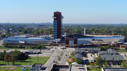
Since the 1990s the neighborhood has seen increased investment. Older homes have been restored, and new housing has been constructed throughout the neighborhood. In 2007 the MotorCity Casino and hotel resort was completed in North Corktown. This has brought much attention to the neighborhood as well as jobs, retail, restaurants, and tourists. Also, Hostel Detroit, opened its doors to travelers in Spring 2011. It is located on Vermont Street.

Developers have set their sights on North Corktown due to its proximity to Corktown, Downtown, and Midtown. Since 2019, there has been increased townhome development in the neighborhood with multiple projects having been completed and currently underway.

See also

Related Research Articles

<span class="mw-page-title-main">Detroit</span> Largest city in Michigan, United States

Detroit is the most populous city in the U.S. state of Michigan. It is the largest U.S. city on the United States–Canada border, and the seat of government of Wayne County. Detroit had a population of 639,111 at the 2020 census, making it the 27th-most populous city in the United States. The Metro Detroit area, home to 4.3 million people, is the second-largest in the Midwest after the Chicago metropolitan area, and the 14th-largest in the United States. A significant cultural center, Detroit is known for its contributions to music, art, architecture and design, in addition to its historical automotive background.

<span class="mw-page-title-main">Corktown, Detroit</span> United States historic place

Corktown is a neighborhood located in Detroit, Michigan. It is the oldest extant neighborhood in the city. The current boundaries of the district include I-75 to the north, the Lodge Freeway to the east, Bagley and Porter streets to the south, and Rosa Parks Boulevard to the west. The neighborhood was listed on the National Register of Historic Places in 1978.

Detroit, the largest city in the state of Michigan, was settled in 1701 by French colonists. It is the first European settlement above tidewater in North America. Founded as a New France fur trading post, it began to expand during the 19th century with American settlement around the Great Lakes. By 1920, based on the booming auto industry and immigration, it became a world-class industrial powerhouse and the fourth-largest city in the United States. It held that standing through the mid-20th century.

<span class="mw-page-title-main">Interstate 375 (Michigan)</span> Interstate Highway in Detroit, Wayne County, Michigan, United States

Interstate 375 (I-375) is a north–south auxiliary Interstate Highway in the city of Detroit, Michigan, United States. It is the southernmost leg of the Walter P. Chrysler Freeway and a spur of I-75 into Downtown Detroit, ending at the unsigned Business Spur I-375, better known as Jefferson Avenue. The freeway opened on June 12, 1964. At only 1.062 miles (1.709 km) in length, it once had the distinction of being the shortest signed Interstate Highway in the country before I-110 in El Paso, Texas, was signed. The Michigan Department of Transportation (MDOT) announced in 2013 that it may remove I-375 in the future, and in 2021 the department announced plans to move forward converting the freeway to a boulevard. Details of that project were revealed in April 2023 with MDOT reaffirming that construction is scheduled to begin in 2025.

<span class="mw-page-title-main">Interstate 275 (Florida)</span> Interstate Highway in Florida

Interstate 275 (I-275), located in Florida, is a 60-mile-long (97 km) auxiliary Interstate Highway serving the Tampa Bay area. Its southern terminus is at I-75 near Palmetto, where I-275 heads west towards the Sunshine Skyway Bridge crossing over Tampa Bay. From that point, I-275 passes through St. Petersburg before crossing Tampa Bay again on the Howard Frankland Bridge, then continues through the city of Tampa, where it connects to an interchange with I-4 in Downtown Tampa. After the interchange, I-275 passes north through the Tampa suburbs to its northern terminus at I-75 in Wesley Chapel.

<span class="mw-page-title-main">Highway revolt</span> Protest against new highways & freeways

Highway revolts are organized protests against the planning or construction of highways, freeways, expressways, and other civil engineering projects that favor motor vehicles.

<span class="mw-page-title-main">Woodbridge, Detroit</span> United States historic place

Woodbridge is a historic neighborhood of primarily Victorian homes located in Detroit, Michigan. The district was listed on the National Register of Historic Places in 1980, with later boundary increases in 1997 and 2008. In addition to its historic value, Woodbridge is also notable for being an intact neighborhood of turn-of-the-century homes within walking or biking distance of Detroit's Downtown, Midtown, New Center, and Corktown neighborhoods.

<span class="mw-page-title-main">Midtown Detroit</span> Cultural center and neighborhood in Wayne, Michigan, United States

Midtown Detroit is a commercial and residential district located along the east and west side of Woodward Avenue, north of Downtown Detroit, and south of the New Center area. The area includes several historic districts. In addition, it contains a residential area of some 14,550 people and covers 2.09 sq mi. The community area of neighborhoods is bounded by the Chrysler Freeway (I-75) on the east, the Lodge Freeway (M-10) on the west, the Edsel Ford Freeway (I-94) on the north, and the Fisher Freeway (I-75) on the south.

<span class="mw-page-title-main">Infill</span> Rededication of land in an urban environment to new construction

In urban planning, infill, or in-fill, is the rededication of land in an urban environment, usually open-space, to new construction. Infill also applies, within an urban polity, to construction on any undeveloped land that is not on the urban margin. The slightly broader term "land recycling" is sometimes used instead. Infill has been promoted as an economical use of existing infrastructure and a remedy for urban sprawl. Its detractors view it as overloading urban services, including increased traffic congestion and pollution, and decreasing urban green-space. Many also detract it for social and historical reasons, partly due to its unproven effects and its similarity with gentrification.

<span class="mw-page-title-main">Lafayette Park, Detroit</span> Neighborhood of Detroit in Wayne County, Michigan, United States

Lafayette Park is an neighborhood located east of Downtown Detroit. It contains a residential area of some 4,900 people and covers 0.07 sq mi.

<span class="mw-page-title-main">Downtown Detroit</span> Area of Detroit, Michigan, United States

Downtown Detroit is the central business district and a residential area of the city of Detroit, Michigan, United States. Locally, downtown tends to refer to the 1.4 square mile region bordered by M-10 to the west, Interstate 75 to the north, I-375 to the east, and the Detroit River to the south. Although, it may also refer to the Greater Downtown area, a 7.2 square mile region that includes surrounding neighborhoods such as Midtown, Corktown, Rivertown, and Woodbridge.

Planning and development in Detroit since the late 20th century has attempted to enhance the economy and quality of life of Detroit, Michigan, United States. In 1970, the private group Detroit Renaissance began to facilitate development in the city. Its successor, Business Leaders for Michigan, has continued to facilitate development into the 21st century. Projects have included new commercial facilities, revitalization of neighborhoods, hospitality infrastructure, and improvements to recreational and public facilities, such as the QLine light rail project.

<span class="mw-page-title-main">Virginia Park Historic District</span> Historic district in Michigan, United States

The Virginia Park Historic District is located on the north side of New Center, an area in Detroit, Michigan, along both sides of Virginia Park Street from Woodward Avenue to the John C. Lodge Freeway access road. The district was listed on the National Register of Historic Places in 1982.

<span class="mw-page-title-main">National Register of Historic Places listings in Detroit</span>

This is a list of the National Register of Historic Places listings in Detroit, Michigan.

<span class="mw-page-title-main">Trails in Detroit</span>

This is a list of trails and greenways in Detroit.

<span class="mw-page-title-main">Gentrification of Atlanta</span>

Gentrification of Atlanta's inner-city neighborhoods began in the 1970s, and it has continued, at varying levels of intensity, into the present. Many factors have contributed to the city's gentrification. A major increase in gentrification that occurred in the last years of the twentieth century has been attributed to the 1996 Summer Olympics. However, during the 2000s, Atlanta underwent a profound transformation demographically, physically, and culturally. Suburbanization, rising prices, a booming economy, and new migrants decreased the city’s black percentage from a high of 67% in 1990 to 54% in 2010. From 2000 to 2010, Atlanta gained 22,763 white residents, 5,142 Asian residents, and 3,095 Hispanic residents, while the city’s black population decreased by 31,678. Much of the city’s demographic change during the decade was driven by young, college-educated professionals: from 2000 to 2009, the three-mile radius surrounding Downtown Atlanta gained 9,722 residents aged 25 to 34 holding at least a four-year degree, an increase of 61%. Between the mid-1990s and 2010, stimulated by funding from the HOPE VI program, Atlanta demolished nearly all of its public housing, a total of 17,000 units and about 10% of all housing units in the city. In 2005, the $2.8 billion BeltLine project was adopted, with the stated goals of converting a disused 22-mile freight railroad loop that surrounds the central city into an art-filled multi-use trail and increasing the city’s park space by 40%. Lastly, Atlanta’s cultural offerings expanded during the 2000s: the High Museum of Art doubled in size; the Alliance Theatre won a Tony Award; and numerous art galleries were established on the once-industrial Westside.

<span class="mw-page-title-main">National Register of Historic Places listings in Downtown and Midtown Detroit</span>

This is a list of the National Register of Historic Places listings in Downtown and Midtown Detroit, Michigan. It is intended to be a complete list of the properties and districts on the National Register of Historic Places in Downtown and Midtown neighborhoods in Detroit, Michigan, United States. Latitude and longitude coordinates are provided for many National Register properties and districts; these locations may be seen together in online maps.

<span class="mw-page-title-main">Summit-University, Saint Paul</span> Neighborhood in Ramsey, Minnesota, United States

Summit-University is a neighborhood in Saint Paul, Minnesota, United States, that stretches roughly from University Avenue in the north, Lexington Parkway to the west, Summit Avenue to the south and to the east along John Ireland Boulevard, Kellogg Boulevard and Marion Street. Summit-University, Selby-Dale, St. Anthony Hill, Cathedral Hill, Woodland Park, Crocus Hill, Ramsey Hill, Hill District, Historic Hill District, Uni-Dale, North Quadrant, and Central Village all refer to parts of the neighborhood that is broadly known as Summit-University.

<span class="mw-page-title-main">North End, Detroit</span> Cultural enclave and neighborhoods in Wayne, Michigan, United States

The North End is a neighborhood located in Detroit, Michigan. It is located in the Woodward Corridor, a densely populated region along Woodward Avenue that stretches from Downtown Detroit to the suburb of Pontiac. The North End has been home to several development initiatives, seen by many as an area for future development extending from Downtown and Midtown.

Highway revolts have occurred in cities and regions across the United States. In many cities, there remain unused highways, abruptly terminating freeway alignments, and short stretches of freeway in the middle of nowhere, all of which are evidence of larger projects which were never completed. In some instances, freeway revolts have led to the eventual removal or relocation of freeways that had been built.

References

  1. Racial Situations: The Class Contradictions of Whiteness in Detroit