The Chrysler Freeway is the name given to a freeway in the Detroit area. It is composed of:
- Interstate 375 (Michigan) south of the junction with the Fisher Freeway
- Interstate 75 in Michigan north of the junction with the Fisher Freeway
The Chrysler Freeway is the name given to a freeway in the Detroit area. It is composed of:

Interstate 96 (I-96) is an east–west Interstate Highway that runs for approximately 192 miles (309 km) entirely within the Lower Peninsula of the US state of Michigan. The western terminus is at an interchange with US Highway 31 (US 31) and Business US 31 on the eastern boundary of Norton Shores southeast of Muskegon, and the eastern terminus is at I-75 near the Ambassador Bridge in Detroit. From Grand Rapids through Lansing to Detroit, the freeway parallels Grand River Avenue, never straying more than a few miles from the decommissioned US 16. The Wayne County section of I-96 is named the Jeffries Freeway from its eastern terminus to the junction with I-275 and M-14. Though maps still refer to the freeway as the Jeffries, the portion within the city of Detroit was renamed by the state legislature as the Rosa Parks Memorial Highway in December 2005 in honor of the late civil rights pioneer. There are four auxiliary Interstates as well as two current and four former business routes associated with I-96.

Interstate 75 (I-75) is a major north–south Interstate Highway in the Great Lakes and Southeastern regions of the United States. As with most Interstates that end in 5, it is a major cross-country, north–south route, traveling from State Road 826 and SR 924 on the Hialeah–Miami Lakes border to Sault Ste. Marie, Michigan, at the Canadian border. It is the second-longest north–south Interstate Highway and the seventh-longest Interstate Highway overall.

Interstate 43 (I-43) is a 191.55-mile-long (308.27 km) Interstate Highway located entirely within the US state of Wisconsin, connecting I-39/I-90 in Beloit with Milwaukee and I-41, U.S. Highway 41 (US 41) and US 141 in Green Bay. State Trunk Highway 32 (WIS 32) runs concurrently with I-43 in two sections and I-94, I-894, US 10, US 41, US 45, and WIS 57 overlap I-43 once each. There are no auxiliary or business routes connected to I-43, though an alternate route to direct traffic during road closures is signed along local and state highways from Milwaukee County north into Brown County.

Interstate 380 (I-380) is a short 3.3-mile (5.3 km) east–west auxiliary Interstate Highway in the San Francisco Bay Area of Northern California, connecting I-280 in San Bruno to US Route 101 (US 101) near San Francisco International Airport. The highway primarily consists of only three intersections: I-280, State Route 82, and US 101. Like the nearby I-280, I-380 never connects to I-80, its parent Interstate Highway. However, there is no rule that says that spur routes need to do so.
Interstate 696 (I-696) is an east–west auxiliary Interstate Highway in the Metro Detroit region of the US state of Michigan. The state trunkline highway is also known as the Walter P. Reuther Freeway, named for the prominent auto industry union head by the Michigan Legislature in 1971. I-696 is a bypass route, detouring around the city of Detroit through the city's northern suburbs in Oakland and Macomb counties. It starts by branching off I-96 and I-275 at its western terminus in Farmington Hills, and runs through suburbs including Southfield, Royal Oak and Warren before merging into I-94 at St. Clair Shores on the east end. It has eight lanes for most of its length and is approximately 10 miles (16 km) north of downtown Detroit. I-696 connects to other freeways such as I-75 and M-10. Local residents sometimes refer to I-696 as "The Autobahn of Detroit".
Interstate 196 (I-196) is an auxiliary Interstate Highway that runs for 80.6 miles (129.7 km) in the US state of Michigan. It is a state trunkline highway that links Benton Harbor, South Haven, Holland, and Grand Rapids. In Kent, Ottawa, and Allegan counties, I-196 is known as the Gerald R. Ford Freeway, or simply the Ford Freeway, after President Gerald Ford, who was raised in Grand Rapids and served Michigan in the House of Representatives for 25 years. This name generally refers only to the section between Holland and Grand Rapids. I-196 changes direction; it is signed as a north–south highway from its southern terminus to the junction with US Highway 31 (US 31) just south of Holland, and as an east–west trunkline from this point to its eastern terminus at an interchange with I-96, its parent highway. There are three business routes related to the main freeway. There are two business loops and one business spur that serve South Haven, Holland and the Grand Rapids areas. Another business spur for Muskegon had been designated relative to the I-196 number.

US Highway 16 (US 16), also called Grand River Avenue for much of its length in the state, was one of the principal roads prior to the post-World War II construction of freeways in the state of Michigan. Before the creation of the United States Numbered Highway System in 1926, the highway had been designated as a state highway numbered M-16. The modern route of Grand River Avenue cuts across the Lower Peninsula in a northwest–southeast fashion from near Grand Rapids to Detroit. Before the late 1950s and early 1960s, US 16 followed other roads between Muskegon and Grand Rapids, and then Grand River Avenue through Lansing to Detroit. In the years immediately preceding the creation of the Interstate Highway System, US 16 was shifted from older roads to newer freeways. Later, it was co-designated as an Interstate. When the gap in the freeway was filled in around Lansing, the US 16 designation was decommissioned in the state. The freeway was solely designated Interstate 96 (I-96) east of Grand Rapids and I-196 west of that city.
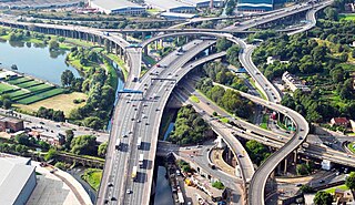
Spaghetti junction is a nickname sometimes given to a complex or massively intertwined road traffic interchange that is said to resemble a plate of spaghetti. Such interchanges may incorporate a variety of interchange design elements in order to maximize connectivity.

U.S. Route 421 is a diagonal northwest–southeast United States Numbered Highway in the states of North Carolina, Tennessee, Virginia, Kentucky, and Indiana. The highway runs for 941 miles (1,514 km) from Fort Fisher, North Carolina, to US 20 in Michigan City, Indiana. Along its routing, US 421 serves several cities including Wilmington, North Carolina; Greensboro, North Carolina; Bristol, Tennessee and Virginia; Lexington, Kentucky; and Indianapolis, Indiana. US 421 is a spur route of US 21, which it meets west of Yadkinville, North Carolina.
Interstate 475 (I-475) is a north–south auxiliary Interstate Highway in the US state of Michigan. I-475 is a 16.9-mile (27.2 km) bypass route that serves the downtown area of Flint while its parent, I-75, passes through the west side of the city. I-475 starts southwest of Grand Blanc and runs through suburbs of Flint before passing through downtown. There, it intersects I-69 and crosses the Flint River. The freeway turns westerly to connect back to I-75 north of Flint near Mount Morris.

A vast network of interconnected freeways in the megaregion of Southern California serves a population of over 23 million people. The Master Plan of Metropolitan Los Angeles Freeways was adopted by the Regional Planning Commission in 1947 and construction began in the early 1950s. The plan hit opposition and funding limitations in the 1970s, and by 2004, only some 61% of the original planned network had been completed.

Interstate 375 (I-375) is a north–south auxiliary Interstate Highway in Detroit, Michigan, United States. It is the southernmost leg of the Walter P. Chrysler Freeway and a spur of I-75 into Downtown Detroit, ending at the unsigned Business Spur I-375, better known as Jefferson Avenue. The freeway opened on June 12, 1964. At only 1.062 miles (1.709 km) in length, it once had the distinction of being the shortest signed Interstate Highway in the country before I-110 in El Paso, Texas, was signed. The Michigan Department of Transportation (MDOT) announced in 2021 plans to convert the freeway to a boulevard. Details of that project were revealed in April 2023 with MDOT reaffirming that construction is scheduled to begin in 2025.

Interstate 275 (I-275) is an auxiliary Interstate Highway in the US state of Michigan that acts as a western bypass of the Detroit metropolitan area. The Michigan Department of Transportation (MDOT) maintains the highway as part of the larger State Trunkline Highway System. The freeway runs through the western suburbs near Detroit Metropolitan Wayne County Airport, and crosses several rivers and rail lines in the area. The southern terminus is the interchange with I-75 near Newport, northeast of Monroe. MDOT considers the Interstate to run to an interchange with I-96, I-696 and M-5 on the Farmington Hills–Novi city line, running concurrently with I-96 for about five miles (8.0 km). This gives a total length of about 35.03 miles (56.38 km), which is backed up by official signage. According to the Federal Highway Administration (FHWA), the length is 29.97 miles (48.23 km) because that agency considers I-275 to end at the junction with I-96 and M-14 along the boundary between Livonia and Plymouth Township. All other map makers, like the American Automobile Association, Rand McNally and Google Maps follow MDOT's practice.

Interstate 75 (I-75) is a part of the Interstate Highway System that runs north–south from Miami, Florida, to Sault Ste. Marie in the Upper Peninsula of the US state of Michigan. I-75 enters the state from Ohio in the south, north of Toledo, and runs generally northward through Detroit, Flint, and Bay City, crosses the Mackinac Bridge, and ends at the Canadian border in Sault Ste. Marie. The freeway runs for approximately 396 miles (637 km) on both of Michigan's major peninsulas. The landscapes traversed by I-75 include Southern Michigan farmland, northern forests, suburban bedroom communities, and the urban core of Detroit. The freeway also uses three of the state's monumental bridges to cross major bodies of water. There are four auxiliary Interstates in the state related to I-75, as well as nine current or former business routes, with either Business Loop I-75 or Business Spur I-75 designations.
The Gerald R. Ford Freeway refers to Interstate Highways named for former President Gerald R. Ford in Omaha and Michigan :
Interstate 94 (I-94) is a part of the Interstate Highway System that runs from Billings, Montana, to the Lower Peninsula of the US state of Michigan. In Michigan, it is a state trunkline highway that enters the state south of New Buffalo and runs eastward through several metropolitan areas in the southern section of the state. The highway serves Benton Harbor–St. Joseph near Lake Michigan before turning inland toward Kalamazoo and Battle Creek on the west side of the peninsula. Heading farther east, I-94 passes through rural areas in the middle of the southern Lower Peninsula, crossing I-69 in the process. I-94 then runs through Jackson, Ann Arbor, and portions of Metro Detroit, connecting Michigan's largest city to its main airport. Past the east side of Detroit, the Interstate angles northeasterly through farmlands in The Thumb to Port Huron, where the designation terminates on the Blue Water Bridge at the Canada–United States border.

Interstate 69 (I-69) is a part of the Interstate Highway System that will eventually run from the Mexican border in Texas to the Canadian border at Port Huron, Michigan. In Michigan, it is a state trunkline highway that enters the state south of Coldwater and passes the cities of Lansing and Flint in the Lower Peninsula. A north–south freeway from the Indiana–Michigan border to the Lansing area, it changes direction to east–west after running concurrently with I-96. The freeway continues to Port Huron before terminating in the middle of the twin-span Blue Water Bridge while running concurrently with I-94 at the border. There are four related business loops for I-69 in the state, connecting the freeway to adjacent cities.

U.S. Route 421 (US 421) is part of the United States Numbered Highway System that runs from Fort Fisher, North Carolina to Michigan City, Indiana. In the U.S. state of North Carolina, US 421 travels 328 miles (528 km) from its southern terminus at Fort Fisher to the Tennessee state line near the community of Zionville, North Carolina. US 421 traverses the state from east to west travelling from the coastal plains to Appalachian Mountains. It provides an important connection between the cities of Wilmington, Sanford, Greensboro, Winston-Salem, and Boone. Despite being signed as north–south, much of the routing of US 421 in North Carolina runs in an east–west direction, particularly between Greensboro and the Tennessee state line. Portions of US 421 have been upgraded to freeway standards including the majority of its routing between Sanford and North Wilkesboro.