Blue Water Bridge

Last updated

Blue Water Bridge
Bluewater Bridge.JPG
Blue Water Bridge, newer bridge in foreground
Coordinates 42°59′55″N82°25′25″W / 42.99861°N 82.42361°W / 42.99861; -82.42361
Carries6 lanes of I-69.svgI-94.svg I-69  / I-94 and Ontario 402 crown.svg Highway 402 (westbound span, 3 lanes; eastbound span, 3 lanes)
Crosses St. Clair River
Locale Port Huron, Michigan and Point Edward, Ontario
Official nameBlue Water Bridge
Maintained by MDOT and Federal Bridge Corporation
Characteristics
Design Cantilever truss (westbound)
Continuous tied arch (eastbound)
Total length6,178 ft (1,883 m) (westbound)
6,109 ft (1,862 m) (eastbound)
Width38 ft (12 m) (westbound)
51 ft (16 m) (eastbound)
Height210 ft (64 m) (westbound)
233 ft (71 m) (eastbound)
Longest span871 ft (265 m) (westbound)
922 ft (281 m) (eastbound)
Clearance below 152 ft (46 m) (westbound)
155 ft (47 m) (eastbound)
History
OpenedOctober 10, 1938;85 years ago (1938-10-10) (westbound)
July 22, 1997;26 years ago (1997-07-22) (eastbound)
Statistics
Daily traffic
  • 13,100 (2015)
  • 14,700 (2014)
  • 14,800 (2013) [1]
TollCars: US$3.00 or C$4.00 (to Canada) and US$3.25 or C$4.25 (to US) As of January 28,2020

Extra axles: US$3.00 or C$4.00 (to Canada) and US$3.25 or C$4.25 (to US)

Trucks & buses: US$3.25 or C$4.25 per axle (to Canada) and US$3.50 or C$4.50 per axle (to US). C$4.25 per axle with Prepaid Account (to US).

Contents

Location
Blue Water Bridge
North Span North Span Bluewater Bridge (Port Huron Mich).jpg
North Span
The Blue Water Bridge during the winter. Blue Water Bridge 3.jpg
The Blue Water Bridge during the winter.

The Blue Water Bridge is a twin-span international bridge across the St. Clair River that links Port Huron, Michigan, United States, and Point Edward, Ontario, Canada. The Blue Water Bridge connects Highway 402 in Ontario with both Interstate 69 (I-69) and Interstate 94 (I-94) in Michigan.

Description

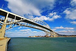
The original span is a cantilever truss bridge with a total length of 6,178 ft (1,883 m) and a main span of 871 ft (265 m). The second, newer span is a continuous bowstring arch bridge with a total length of 6,109 ft (1,862 m) and a main span of 922 ft (281 m).

The Blue Water Bridges are jointly owned and maintained by Canada and the United States: Federal Bridge Corporation, a Crown corporation of the Government of Canada, is in charge of the Canadian side, [2] while the Michigan Department of Transportation (MDOT) is in charge of the US side. [3] A toll is charged to cross the bridges, which is used to pay for maintenance and operations.

Together, the two bridges connect Chicago and the Midwestern United States with Toronto and the Northeastern United States, one of the four shortest routes of land travel between the US Midwest and Northeast. They are the second-busiest commercial crossing on the Canada–United States border, after the Ambassador Bridge at Detroit-Windsor, [4] and the fourth-busiest overall international crossing in Ontario in terms of total number of vehicles [5] at 4.7 million annually as of 2011. [6] In Canada, they are the third-busiest bridges after the Champlain Bridge in Montreal and the Ambassador Bridge.

Border crossing

The Port Huron–Point Edward Border Crossing connects the cities of Port Huron, Michigan, and Point Edward, Ontario, at the Blue Water Bridge. Both the US and Canada border stations are open 24 hours per day. The US Customs and Border Protection upgraded its inspection facilities in 2011, and Canada Border Services Agency upgraded its facilities in 2012. In 2017, inspectors at Port Huron processed 1,579,646 cars and 826,288 trucks. [7]

History

A US Port of Entry was established at the location in 1836, when a license to provide commercial ferry service between Port Huron and what then was known as Port Sarnia. The license was issued to a Canadian man named Crampton who operated a sailboat. In the 1840s, a man named Davenport, also from Port Sarnia, operated a pony-powered vessel. Steam-powered vessels and paddle wheelers soon followed, but the first vessel capable of carrying automobiles did not arrive until 1921. [8]

The first bridge was fully opened to traffic on October 10, 1938. [9] The lead engineer was Polish-born Ralph Modjeski. This bridge originally had two lanes for vehicles as well as sidewalks; the latter were removed in the 1980s to make room for a third lane for automobiles. The third lane for each direction started from the apex of the bridge in order to accommodate long lineups entering each side's border crossing.

In 1935, the Michigan Legislature passed a law (Public Act 147 of 1935 [10] ) creating a State Bridge Commission to finance the design and erection of the main bridge structure of the Blue Water Bridge. The commission was approved by the United States Congress in August 1935 (Public Law 411 of 1935 [11] ). The law permitted the commission to sell bonds that would be repaid by the revenue from the tolls ($0.25 toll for travelers) collected within 30 years. When the bridge and its associated bonds were paid off, Michigan Governor John Swainson used an executive order to cancel the $0.25 toll, eliminating the jobs of toll collectors, which included his own father. [12]

In 1937, after plans proposed in 1927 to build a bridge spanning the St. Clair River languished during the Great Depression, the Michigan Highway Commission and the Minister of Highways for Canada hired Ralph Modjeski and Frank H. Masters and their Canadian associates, Charles Monsarrat and Philip Louis Pratley to design and build what would become the Blue Water Bridge [13] . Ralph Modjeski, a Polish-born engineer who would become known as "America's greatest bridge builder", served as lead engineer for the project. In developing a design, Modjeski faced obstacles posed by the U.S. Army Corps of Engineers, which sought to ensure that the St. Clair River remain navigable for military and commercial vessels. Bridge construction could not interfere with navigation, bridge builders could not use floating platforms, and the completed span was required to clear the water by 150 ft (46 m). Originally, Modjeski proposed a mammoth suspension-style bridge with tall towers and massive cable anchorages; however, because of the 150 ft (46 m) vertical clearance requirement for shipping, he opted instead for a cantilevered through-truss design.[ citation needed ]

In 1964, the eastern terminus of I-94 was completed at the foot of the Blue Water Bridge on the American side. [14] Traffic volumes steadily increased, spurred by the completion of Highway 402 in 1982 which provided a continuous freeway link to Highway 401 on the Canadian side. In 1984, I-69 was completed to Port Huron which meant that three freeways converged on the three-lane bridge. [15] [16]

Twinning project

As a precursor to the upcoming twinning project, the customs and toll collection booths on both sides were extensively reconfigured in the early 1990s. On the American side, the I-beam girder overpass crossing Pine Grove Avenue was replaced by a much wider embankment, which also added a four-story customs office building in the center. On the Canadian side this necessitated the demolition of the original booths that had been in use since 1938; these were noted for their Art Deco style but they were too low to accommodate semi-trailer trucks which had been directed to the outside. [17] [18]

In 1992, it was determined that traffic on the bridge had exceeded its rated capacity, [19] [20] so bridge authorities decided to add a second span in order to accommodate the higher traffic.

During the debate over the form of the second span from 1994 to 1995, five possible designs were proposed. The parallel chord truss Bridge and the single-span tied-arch bridge proposals were the least popular as they were not visually appealing and dropped from further consideration. Over half of public opinion had favored a duplicate of the first bridge, while the cable-stayed bridge came in second with around 21% thanks to its "dramatic appearance and appeal to engineers because of their high structural redundancy". The Blue Water Bridge Authority had rejected both designs that topped public opinion, because the duplicate bridge would create a false sense of history, while the cable-stayed design would overshadow the existing bridge in height and proportion. The continuous-tied arch design, which was a distant third place in polls, was chosen for two reasons: one was that it blends in with the original span yet stands out on its own, and the other is lower maintenance costs because fewer spans are involved. [21]

The selection of the continuous-tied arch proposal was initially controversial as it did not have much public opinion support, and critics regarded this type as awkward. Consequently, the engineers changed design details to make it complement the existing bridge. For instance the use of concrete piers and steel tower supporting the anchor span, rather than the traditional concrete tower, gave the bridge a "less massive appearance, easing the difficult transition between the approach, anchor and main spans". The engineers also made "the main span attractive, but economical by settling on an innovative low arch design that merges the traffic deck with the bottom structural supporting steel for the portion of the bridge suspended over the water", which "eliminated the need for expensive bracing and contributes to the graceful appearance of the structure", while the flattened arch also better matches the old bridge. For the new bridge approaches the engineers selected concrete hammer-head piers over steel piers and deck trusses, not only for economical considerations, but it also "gives the new bridge a simpler look, making it easier to distinguish the old bridge from the new one" and "contributes to the clean lines of the new bridge and leaves the view of the old bridge's deck trusses uncluttered". Due to each country's manufacturing differences, the Americans used large pre-cast concrete beams (six beams for each segment) for the approaches while the Canadians used concrete pre-cast box girders (three box girders per segment). Despite this, the differing approach spans are the same depth and appear identical from the side view. [21]

The twinning project was a combined effort between Modjeski & Masters (American engineers) and Buckland & Taylor Ltd. (Canadian engineers). During the construction, two temporary masts were erected to assist in the construction of the tied arch; the towers were painted red and lighted, enabling them to be seen from afar. [22] The approaches to the new bridge use box girders, compared to the original which hold up the road deck with trusses. [23]

The second three-lane bridge, just south of the first bridge, opened on July 22, 1997. [24]

Rehabilitation of original bridge

After the new bridge opened for traffic, the original bridge was immediately closed for extensive renovation which involved, among other things, replacement of the bridge deck, guardrails, and lighting. During this period, the new span used a three-lane configuration reminiscent of the one employed on the original bridge. A flyover ramp on the U.S. side temporarily diverted westbound traffic from the new bridge to the toll plaza, which was blocked off after the original bridge was rehabilitated. [25] The original span was reopened on November 13, 1999, making the Blue Water Bridge the largest infrastructure-crossing project in North America. [26]

Since twinning

In 2007, in accordance with Federal Identity Program requirements, the Blue Water Bridge Authority agreed on a name for the federal Crown corporate organization: Blue Water Bridge Canada. [27]

In March 2009, the Canadian government announced that C$13.5 million (US$10.8 million) in funding would be allocated toward upgrading the border crossing facilities at the Blue Water Bridge. The work was scheduled to begin in May 2009. [28]

Construction was also underway in 2011 to widen and improve both Highway 402 on the Canadian side [29] and co-signed I-94/I-69 on the American side approaching the Blue Water Bridge. [30] The projects, completed the following year, added dedicated lanes separating Blue Water Bridge traffic from local traffic.

Blue water bridge.jpg
Blue Water Bridge, 2014

See also

Related Research Articles

<span class="mw-page-title-main">Sarnia</span> City in Ontario, Canada

Sarnia is a city in Lambton County, Ontario, Canada. It had a 2021 population of 72,047, and is the largest city on Lake Huron. Sarnia is located on the eastern bank of the junction between the Upper and Lower Great Lakes where Lake Huron flows into the St. Clair River in the Southwestern Ontario region, which forms the Canada–United States border, directly across from Port Huron, Michigan.

<span class="mw-page-title-main">St. Clair County, Michigan</span> County in Michigan, United States

St. Clair County is a county located in the U.S. state of Michigan and bordering the west bank of the St. Clair River. As of the 2020 census, the population was 160,383. It is the 13th-most populous county in the state. The county seat is Port Huron, located at the north end of the St. Clair River at Lake Huron. The county was created September 10, 1820, and its government was organized in 1821. It is located northeast of Detroit and is included within the Detroit–Warren–Dearborn Metropolitan Statistical Area by the Office of Management and Budget. It is also considered by the State of Michigan to be a part of The Thumb, a peninsula that is surrounded by Lake Huron in the east-central area of the state. This area is sometimes dubbed the Blue Water Area.

<span class="mw-page-title-main">Port Huron, Michigan</span> City in Michigan, United States

Port Huron is a city in the U.S. state of Michigan and the county seat of St. Clair County. The population was 28,983 at the 2020 census. The city is bordered on the west by Port Huron Township, but the two are administered autonomously.

<span class="mw-page-title-main">Ambassador Bridge</span> Suspension bridge connecting Detroit, Michigan, with Windsor, Ontario

The Ambassador Bridge is a tolled international suspension bridge across the Detroit River that connects Detroit, Michigan, United States, with Windsor, Ontario, Canada. Opened in 1929, it is the busiest international border crossing in North America in terms of trade volume, carrying more than 25% of all merchandise trade between the United States and Canada by value. A 2004 Border Transportation Partnership study showed that 150,000 jobs in the Detroit–Windsor region and US$13 billion in annual production depend on the Detroit–Windsor international border crossing.

<span class="mw-page-title-main">Sault Ste. Marie International Bridge</span> Bridge connecting Canada and the United States

The Sault Ste. Marie International Bridge spans the St. Marys River between the United States and Canada connecting the twin cities of Sault Ste. Marie, Michigan and Sault Ste. Marie, Ontario. The bridge is operated by the International Bridge Administration under the direction of the Sault Ste. Marie Bridge Authority, a bi-national governing body consisting of four directors appointed by the Governor of Michigan and four appointed by the Canadian government-owned Federal Bridge Corporation.

<span class="mw-page-title-main">Peace Bridge</span> Truss arch bridge connecting US to Canada

The Peace Bridge is an international bridge between Canada and the United States at the east end of Lake Erie at the source of the Niagara River, about 20 kilometres (12.4 mi) upriver of Niagara Falls. It connects Buffalo, New York, in the United States to Fort Erie, Ontario, in Canada. It is operated and maintained by the binational Buffalo and Fort Erie Public Bridge Authority.

<span class="mw-page-title-main">Southern Ontario</span> Primary region in Ontario, Canada

Southern Ontario is a primary region of the Canadian province of Ontario. It is the most densely populated and southernmost region in Canada, with approximately 13.5 million people, approximately 36% of Canada's population of 37 million. The region lies south of the province's other primary region, Northern Ontario, although the exact northern boundary of Southern Ontario is disputed. However, its core region is situated south of Algonquin Park, the latter being in an area of transition between coniferous forest north of the French and Mattawa Rivers and southern deciduous forest. It covers between 14 and 15% of the province, depending on the inclusion of the Parry Sound and Muskoka districts which also lie in the transitional area between northern and southern forest regions. Southern Ontario differs greatly from Northern Ontario, having a much higher population density, a different climate, and a different culture than its northern counterpart. It is broken into smaller subregions, including Central Ontario, Eastern Ontario, the Golden Horseshoe, and Southwestern Ontario.

<span class="mw-page-title-main">Lambton County</span> County in Ontario, Canada

Lambton County is a county in Southwestern Ontario, Canada. It is bordered on the north by Lake Huron, which is drained by the St. Clair River, the county's western border and part of the Canada-United States border. To the south is Lake Saint Clair and Chatham-Kent. Lambton County's northeastern border follows the Ausable River and Parkhill Creek north until it reaches Lake Huron at the beach community of Grand Bend. The county seat is in the Town of Plympton-Wyoming.

The Thumb is a region and a peninsula of the U.S. state of Michigan, so named because the Lower Peninsula is shaped like a mitten. The Thumb area is generally considered to be in the Central Michigan region, east of the Tri-Cities and north of Metro Detroit. The region is also branded as the Blue Water Area.

<span class="mw-page-title-main">Detroit–Windsor tunnel</span> International tunnel between United States and Canada

The Detroit–Windsor tunnel, also known as the Detroit–Canada tunnel, is an international highway tunnel connecting the cities of Detroit, Michigan, United States and Windsor, Ontario, Canada. It is the second-busiest crossing between the United States and Canada, the first being the Ambassador Bridge, which also connects the two cities, which are situated on the Detroit River.

King's Highway 402, commonly referred to as Highway 402 and historically as the Blue Water Bridge Approach, is a 400-series highway in the Canadian province of Ontario that connects the Blue Water Bridge international crossing near Sarnia to Highway 401 in London. It is one of multiple trade links between Ontario and the Midwestern United States. It is four lanes for much of its length, though the approach to the Blue Water Bridge is six lanes.

<span class="mw-page-title-main">St. Clair Tunnel</span>

The St. Clair Tunnel is the name for two separate rail tunnels which were built under the St. Clair River between Sarnia, Ontario and Port Huron, Michigan. The original, opened in 1891 and used until it was replaced by a new larger tunnel in 1995, was the first full-size subaqueous tunnel built in North America. It is a National Historic Landmark of the United States, and has been designated a civil engineering landmark by both US and Canadian engineering bodies.

<span class="mw-page-title-main">I-74 Bridge</span> Bridges across the Mississippi River between Iowa and Illinois

The Interstate 74 Bridge, officially known as the Iowa-Illinois Memorial Bridge, and often called The Twin Bridges, or the I-74 Bridge, are basket-handle, through arch twin bridges that carry Interstate 74 across the Mississippi River and connect Bettendorf, Iowa, and Moline, Illinois. It is located near the geographic center of the Quad Cities.

<i>International</i> (Amtrak train) American named passenger train (1982–2004)

The International was a named passenger train operated between Chicago and Toronto. It was originally an overnight train operated by the Grand Trunk Railway of Canada and its successors the Canadian National Railway and Grand Trunk Western Railroad, running as far as Montreal. The train was cut back to Port Huron, Michigan, in 1970 and discontinued in 1971.

King's Highway 40, commonly referred to as Highway 40, is a provincially maintained highway in the southwestern portion of the Canadian province of Ontario. The 91.4-kilometre (56.8 mi) route links Chatham and Sarnia via Wallaceburg, following close to the St. Clair River. The southern terminus is at Highway 401 south of Chatham, while the northern terminus is at Highway 402 in Sarnia. The portion of Highway 40 between Highway 401 and north of Wallaceburg is within the municipality of Chatham-Kent, while the portion north of there is within Lambton County.

<span class="mw-page-title-main">Interstate 94 in Michigan</span> Interstate Highway in Michigan, United States

Interstate 94 (I-94) is a part of the Interstate Highway System that runs from Billings, Montana, to the Lower Peninsula of the US state of Michigan. In Michigan, it is a state trunkline highway that enters the state south of New Buffalo and runs eastward through several metropolitan areas in the southern section of the state. The highway serves Benton Harbor–St. Joseph near Lake Michigan before turning inland toward Kalamazoo and Battle Creek on the west side of the peninsula. Heading farther east, I-94 passes through rural areas in the middle of the southern Lower Peninsula, crossing I-69 in the process. I-94 then runs through Jackson, Ann Arbor, and portions of Metro Detroit, connecting Michigan's largest city to its main airport. Past the east side of Detroit, the Interstate angles northeasterly through farmlands in The Thumb to Port Huron, where the designation terminates on the Blue Water Bridge at the Canada–United States border.

<span class="mw-page-title-main">Interstate 69 in Michigan</span> Interstate Highway in Michigan, United States

Interstate 69 (I-69) is a part of the Interstate Highway System that will eventually run from the Mexican border in Texas to the Canadian border at Port Huron, Michigan. In Michigan, it is a state trunkline highway that enters the state south of Coldwater and passes the cities of Lansing and Flint in the Lower Peninsula. A north–south freeway from the Indiana–Michigan border to the Lansing area, it changes direction to east–west after running concurrently with I-96. The freeway continues to Port Huron before terminating in the middle of the twin-span Blue Water Bridge while running concurrently with I-94 at the border. There are four related business loops for I-69 in the state, connecting the freeway to adjacent cities.

<span class="mw-page-title-main">Twin bridges</span> Set of two bridges running parallel to each other

Twin bridges are a set of two bridges running parallel to each other. A pair of twin bridges is often referred to collectively as a twin-span or dual-span bridge. Twin bridges are independent structures and each bridge has its own superstructure, substructure, and foundation. Bridges of this type are often created by building a new bridge parallel to an existing one in order to increase the traffic capacity of the crossing. While most twin-span bridges consist of two identical bridges, this is not always the case.

<span class="mw-page-title-main">Blue Water Bridge Authority</span>

The Blue Water Bridge Authority was a Canadian Crown corporation responsible for the operation and maintenance of the Canadian side of the Blue Water Bridge in Point Edward, Ontario. It was established on May 21, 1964 via the Blue Water Bridge Authority Act (Canada), which authorized it to provide highway traffic between Canada and the United States over the Blue Water Bridge. It was granted exclusive rights to levy tolls on westbound traffic from Canada to the United States in order to offset the costs of operation, maintenance, and construction.

<span class="mw-page-title-main">Port Huron–Sarnia Border Crossing</span> International border crossing

The Port Huron–Sarnia Border Crossing connects the cities of Port Huron, Michigan and Sarnia, Ontario. It is located at the Blue Water Bridge at the St. Clair River.

References

  1. "Blue Water Bridge". Federal Bridge Corporation. Archived from the original (XLS) on November 14, 2016. Retrieved November 14, 2016.
  2. "Corporate Amalgamation". Federal Bridge Corporation Limited. January 30, 2015. Retrieved November 14, 2016.
  3. "Blue Water Bridge Canada 2013-2014 Annual Report" (PDF). p. 2. Archived from the original (PDF) on November 13, 2016. Retrieved November 12, 2016.
  4. "Chapter 4: The Watery Boundary". United Divide: A Linear Portrait of the USA/Canada Border. The Center for Land Use Interpretation. Winter 2015.
  5. "Who We Are". Blue Water Bridge. Retrieved November 12, 2016.
  6. Sheridan, Margaret (June 24, 2011). "Port Huron: Gateway to Canada worth a stay". Chicago Tribune. Retrieved December 4, 2017.
  7. Bureau of Transportation Statistics. "Border Crossing/Entry Data". United States Department of Transportation. Retrieved March 1, 2019.
  8. Elford, Jean Turnbull. "Sarnia-Port Huron Ferries". Canada West’s Last Frontier. Retrieved August 22, 2018 via Sarnia Historical Society.
  9. "Official Program: Dedication and Opening of the Blue Water Bridge". Blue Water Bridge: Commemorative Number. Sarnia, Ontario: The Herald. October 8, 1938. n.p. Retrieved August 3, 2015 via Archive.org.
  10. 1935 PA 147: State Bridge Commission; Public Works
  11. Pub. L. Tooltip Public Law (United States)  74–411
  12. "People". Time . February 16, 1962. Archived from the original on October 18, 2007. Retrieved July 15, 2012.
  13. https://sah-archipedia.org/buildings/MI-01-SC13
  14. "I-94 Terminus Is Dedicated". The Holland Evening Sentinel . United Press International. October 14, 1964. p. 12. ISSN   1050-4044. OCLC   13440201 . Retrieved May 3, 2015 via Newspapers.com. Open Access logo PLoS transparent.svg
  15. Michigan Department of Transportation (1984). Say Yes to Michigan!: Official Transportation Map (Map). c. 1:918,720. Lansing: Michigan Department of Transportation. §§ K12–K14. OCLC   12701177 . Retrieved October 17, 2019 via Michigan History Center.
  16. Michigan Department of Transportation (1985). Yes Michigan: Official Transportation Map (Map). c. 1:918,720. Lansing: Michigan Department of Transportation. §§ K12–K14. OCLC   12701177 . Retrieved October 17, 2019 via Michigan History Center.
  17. "Ontario Highway 402 Photographs - Page 1 - History of Ontario's Kings Highways".
  18. Leiffer, Len (1967). Bluewater Bridge Customs Building. thekingshighway.ca (postcard). Point Edward, Ontario.
  19. "Corporate Plan 2011-2012 to 2015-2016" (PDF). Blue Water Bridge Canada. p. 9. Archived from the original (PDF) on November 13, 2016. Retrieved November 12, 2016.
  20. "My Favourite Way to Leave Michigan". April 3, 2005. Archived from the original on November 2, 2012. Retrieved May 1, 2010.
  21. 1 2 Construction History of the Blue Water Bridges (PDF). State of Michigan. pp. 4–6. Retrieved August 26, 2018.
  22. "Blue Water Bridge (Original/Westbound Span)". HistoricBridges.org. July 7, 2015. Retrieved February 27, 2016.
  23. Thoeun, Bun (December 20, 2010). "Bluewater Bridge Sarnia Ontario 1" . Retrieved February 27, 2016 via Flickr.
  24. Egan, Paul (July 23, 1997). "Just Another Day for Cars, Trucks as New Blue Water Bridge Opens". Times Herald. Port Huron, MI. p. 1A. OCLC   36177739 . Retrieved August 26, 2018 via Newspapers.com. Open Access logo PLoS transparent.svg
  25. "Blue Water Bridge Canada". Archived from the original on December 30, 2012. Retrieved January 17, 2013.
  26. "Construction of the Second Span". Blue Water Bridge. Retrieved November 13, 2016.
  27. "Corporate Plan Summary 2010-2011 to 2014-2015" (PDF). p. 7. Archived from the original (PDF) on December 26, 2010. Retrieved January 24, 2012.
  28. "Canadian PM announces funding for bridge connecting United States". March 21, 2009. Archived from the original on June 27, 2009. Retrieved March 20, 2009.
  29. "Hwy. 402 construction closes on/off ramps". The Sarnia Observer. Archived from the original on March 23, 2012. Retrieved September 16, 2011.
  30. "I-94/I-69 Reconstruction in St. Clair County". Michigan Department of Transportation. July 14, 2011. Archived from the original on September 17, 2011. Retrieved September 16, 2011.