Wisconsin Territory depicted on this 1835 Tourist's Pocket Map Of Michigan, showing a Menominee-filled Brown County, Wisconsin that spans the northern half of the territory.
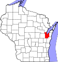
Brown County is one of Wisconsin's two original counties, along with Crawford County. It originally spanned the entire eastern half of the state when formed by the Michigan Territorial legislature in 1818.[citation needed] It was named for Major General Jacob Brown, a military leader during the War of 1812.[3][4]
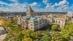
Several towns along the Fox River vied for the position of county seat in Brown County's early years. The first county seat was located at Menomoneeville (now a part of Allouez) in 1824. In 1837, a public referendum relocated the county seat to De Pere. The location was put up for the popular vote again in 1854, resulting in the establishment of the present county seat at Green Bay.[5]
The oldest known tree in Wisconsin, a 1,300-year-old cedar growing on the Niagara Escarpment, was found in Brown County.[6]
Geography
According to the U.S. Census Bureau, the county has a total area of 616 square miles (1,600km2), of which 530 square miles (1,400km2) is land and 86 square miles (220km2) (14%) is water.[7]
In 2017, there were 3,324 births, giving a general fertility rate of 65.6 births per 1000 women aged 15–44, which is above the Wisconsin average of 60.1.[9] Additionally, there were 168 reported induced abortions performed on women of Brown County residence, with a rate of 3.3 abortions per 1000 women aged 15–44, which is below the Wisconsin average rate of 5.2.[10]
U.S. Decennial Census[12] 1790–1960[13] 1900–1990[14] 1990–2000[15] 2010–2020[1]
2020 census
As of the 2020 census, the county had a population of 268,740, the median age was 37.9 years, 23.3% of residents were under the age of 18, and 15.7% were 65 years of age or older. For every 100 females there were 98.4 males, and for every 100 females age 18 and over there were 96.7 males age 18 and over.[16]
The population density was 507.0 peopleper square mile (195.8 people/km2). There were 112,908 housing units at an average density of 213.0 unitsper square mile (82.2 units/km2).[17]
There were 108,156 households in the county, of which 29.6% had children under the age of 18 living in them. Of all households, 47.8% were married-couple households, 18.7% were households with a male householder and no spouse or partner present, and 24.8% were households with a female householder and no spouse or partner present. About 29.4% of all households were made up of individuals and 11.1% had someone living alone who was 65 years of age or older.[16]
Of the 112,908 housing units, 4.2% were vacant. Among occupied housing units, 64.3% were owner-occupied and 35.7% were renter-occupied. The homeowner vacancy rate was 0.9% and the rental vacancy rate was 4.5%.[16]
83.4% of residents lived in urban areas, while 16.6% lived in rural areas.[19]
2010 census
At the 2010 census there were 248,007 people, 98,383 households, and 63,721 families living in the county. The population density was 403 peopleper square mile (156 people/km2). There were 104,371 housing units at an average density of 170 unitsper square mile (66 units/km2). The racial makeup of the county was 86.5% White, 2.2% Black or African American, 2.7% Native American, 2.7% Asian, 0.0004% Pacific Islander, 3.7% from other races, and 2.2% from two or more races. 7.3% of the population were Hispanic or Latino of any race.[20] Of the 98,383 households 31.0% had children under the age of 18 living with them, 50.0% were married couples living together, 10.2% had a female householder with no husband present, and 35.2% were non-families. 27.7% of households were one person and 8.9% were one person aged 65 or older. The average household size was 2.45 and the average family size was 3.02.
The age distribution was 24.1% under the age of 18, 10.8% from 18 to 24, 26.9% from 25 to 44, 26.6% from 45 to 64, and 11.6% 65 or older. The median age was 36.2 years. For every 100 females, there were 97.80 males. For every 100 females age 18 and over, there were 95.70 males.
2000 census
2000 Census Age Pyramid for Brown County
At the 2000 census there were 226,778 people, 87,295 households, and 57,527 families living in the county. The population density was 429 peopleper square mile (166 people/km2). There were 90,199 housing units at an average density of 171 unitsper square mile (66 units/km2). The racial makeup of the county was 91.14% White, 1.16% Black or African American, 2.29% Native American, 2.18% Asian, 0.03% Pacific Islander, 1.90% from other races, and 1.30% from two or more races. 3.84% of the population were Hispanic or Latino of any race. 33.8% were of German, 8.9% Polish, 7.8% Belgian and 6.8% Irish ancestry. 93.2% spoke only English at home, 3.8% spoke Spanish and 1.2% Hmong.[20] Of the 87,295 households 33.90% had children under the age of 18 living with them, 53.20% were married couples living together, 8.90% had a female householder with no husband present, and 34.10% were non-families. 26.50% of households were one person and 8.40% were one person aged 65 or older. The average household size was 2.51 and the average family size was 3.08.
The age distribution was 26.10% under the age of 18, 10.50% from 18 to 24, 31.90% from 25 to 44, 20.90% from 45 to 64, and 10.70% 65 or older. The median age was 34 years. For every 100 females, there were 98.90 males. For every 100 females age 18 and over, there were 96.90 males.
Government
The legislative branch of Brown County is the 26-member Board of Supervisors. Each member represents a single district and serves a two-year term, with elections held in the spring of even-numbered years. The Board of Supervisors elects a chairman and Vice Chairman from its membership.
The executive branch of Brown County is the County Executive, who is elected in the spring of every other odd-numbered year. The executive appoints department heads with the approval of the County Board. The current county executive is Troy Streckenbach.
Brown County has several other elected officials that are established under the Wisconsin State constitution and are referred to as the "constitutional officers". Constitutional officers are the only partisan elected officials within Brown County government, as the Executive and County Board are non-partisan positions.
Brown County and adjacent counties, in the early morning of January 1, 2018, taken from the International Space Station
Green Bay, center, is the seat of Brown County. The city of Oconto (half cut off at the bottom right) is the county seat of Oconto County. Slightly above and much further right of Oconto is Oconto Falls, also in Oconto County. The somewhat larger city above Oconto Falls is Pulaski, which is in Brown County at the very border with Shawano County. Shawano County extends between Pulaski and past the edge of the photograph.
The large city in the top right is Appleton, the county seat of Outagamie County. To the left of Appleton and across the northern edge of Lake Winnebago is Brillion in Calumet County.
The village directly to the left of Green Bay and its immediate suburbs is Denmark, in Brown County. The smaller communities above and slightly to the left of Denmark (including Cooperstown, Maribel, and Kellnersville) are in Manitowoc County.
Luxembourg (larger village in lower left) and Casco (half cut off at lower far left) are in Kewaunee County.
Politics
Brown County is rather conservative for an urban county. Since 1968, Brown County has voted for the Republican presidential candidate in all but two elections, 1996 and 2008. Democratic strength is concentrated in the city of Green Bay, while the suburban and rural areas typically vote Republican.[21]
United States presidential election results for Brown County, Wisconsin[22]
↑Reported Induced Abortions in Wisconsin, Office of Health Informatics, Division of Public Health, Wisconsin Department of Health Services. Section: Trend Information, 2013-2017, Table 18, pages 17-18
This page is based on this Wikipedia article Text is available under the CC BY-SA 4.0 license; additional terms may apply. Images, videos and audio are available under their respective licenses.