Coppens Corner, Wisconsin | |
|---|---|
 Coppens Corner  Coppens Corner | |
| Coordinates: 44°27′30″N87°47′08″W / 44.45833°N 87.78556°W | |
| Country | |
| State | |
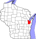
| County | Brown |
| Town | Eaton |
| Elevation | 899 ft (274 m) |
| Time zone | UTC-6 (Central (CST)) |
| • Summer (DST) | UTC-5 (CDT) |
| Area code | 920 |
| GNIS feature ID | 1577558 [1] |
Coppens Corner is an unincorporated community in the Town of Eaton, Brown County, Wisconsin, United States. [1]
It is located at the corner of County Trunk JJ and County Trunk P. [2] The community was named for Phil and Catherine Coppens, who owned land in the area in the 1860s. [3]