Holland, Brown County, Wisconsin

Last updated

Holland, Wisconsin
Holland Brown County Wisconsin town hall.jpg
Town hall for Holland
Brown County Wisconsin incorporated and unincorporated areas Holland highlighted.svg
Location in Brown County and the state of Wisconsin.
Coordinates: 44°16′21″N88°7′35″W / 44.27250°N 88.12639°W / 44.27250; -88.12639
Country Flag of the United States.svg  United States
State Flag of Wisconsin.svg  Wisconsin
County Brown
Area
  Total3 sq mi (93.2 km2)
  Land3 sq mi (93.2 km2)
  Water0.0 sq mi (0.0 km2)
Elevation
[1]
768 ft (234 m)
Population
 (2010)
  Total1,519
  Density42/sq mi (16.3/km2)
Time zone UTC-6 (Central (CST))
  Summer (DST) UTC-5 (CDT)
Area code 920
FIPS code 55-35325 [2]
GNIS feature ID1583400 [1]
Website www.holland-wi.us
Looking south at the unincorporated village of Hollandtown HollandWisconsinBrownCounty1.jpg
Looking south at the unincorporated village of Hollandtown
The sign for Hollandtown HollandWisconsinBrownCountySign.jpg
The sign for Hollandtown

Holland is a town in Brown County in the U.S. state of Wisconsin. The population was 1,519 at the 2010 census. [3] The unincorporated communities of Askeaton and Hollandtown are located in the town.

Contents

Geography

Holland occupies the southwest corner of Brown County, with Outagamie County to the west and Calumet and Manitowoc counties to the south.

According to the United States Census Bureau, the town has a total area of 36.0 square miles (93.2 km2), all of it land. [3]

Demographics

As of the census [2] of 2000, there were 1,339 people, 433 households, and 352 families residing in the town. The population density was 37.2 people per square mile (14.4/km2). There were 444 housing units at an average density of 12.3 per square mile (4.8/km2). The racial makeup of the town was 98.58% White, 0.07% African American, 0.37% Native American, 0.67% Asian, and 0.30% from two or more races. Hispanic or Latino of any race were 0.52% of the population.

There were 433 households, out of which 42.7% had children under the age of 18 living with them, 71.6% were married couples living together, 3.5% had a female householder with no husband present, and 18.5% were non-families. 14.3% of all households were made up of individuals, and 5.1% had someone living alone who was 65 years of age or older. The average household size was 3.09 and the average family size was 3.45.

In the town, the population was spread out, with 31.9% under the age of 18, 8.4% from 18 to 24, 31.5% from 25 to 44, 20.2% from 45 to 64, and 8.1% who were 65 years of age or older. The median age was 34 years. For every 100 females, there were 106.3 males. For every 100 females age 18 and over, there were 110.1 males.

The median income for a household in the town was $56,406, and the median income for a family was $63,594. Males had a median income of $38,333 versus $24,803 for females. The per capita income for the town was $20,481. About 2.8% of families and 3.6% of the population were below the poverty line, including 5.7% of those under age 18 and none of those age 65 or over.

Related Research Articles

<span class="mw-page-title-main">Fairview, Alabama</span> Town in Alabama, United States

Fairview is a town in Cullman County, Alabama, United States. At the 2010 census the population was 446, down from 522 in 2000. It incorporated in 1968.

<span class="mw-page-title-main">Douglas, Alabama</span> Town in Alabama, United States

Douglas is a town in Marshall County, Alabama, United States. Douglas, a part of the Huntsville–Decatur Combined Statistical Area, had a population of 761 as of the 2020 census. The town incorporated in 1978.

<span class="mw-page-title-main">Lacoochee, Florida</span> CDP in Florida, United States

Lacoochee is a census-designated place (CDP) in Pasco County, Florida, United States. The population was 1,345 at the 2000 census.

<span class="mw-page-title-main">Vidette, Georgia</span> City in Georgia, United States

Vidette is a city in Burke County, Georgia, United States. The population was 112 at the 2010 census. It is part of the Augusta, Georgia metropolitan area.

<span class="mw-page-title-main">Hope, Idaho</span> City in Idaho, United States

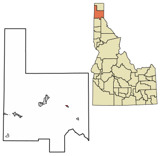
Hope is a city in Bonner County, Idaho, United States. The population was 86 at the 2010 census.

<span class="mw-page-title-main">Hopkinton, Iowa</span> City in Iowa, United States

Hopkinton is a city in Delaware County, Iowa, United States. The population was 622 at the time of the 2020 census.

Newark Township is a civil township of Gratiot County in the U.S. state of Michigan. The population was 1,149 at the 2000 census.

<span class="mw-page-title-main">Plainview, Minnesota</span> City in Minnesota, United States

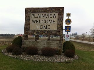
Plainview is a city in Wabasha County, Minnesota, United States. The population was 3,340 at the 2010 census. The author Jon Hassler was raised in Plainview and some of the places in his writing are based on the town.

<span class="mw-page-title-main">Plantersville, Mississippi</span> Town in Mississippi, United States

Plantersville is a town in Lee County, Mississippi. The population was 868 at the 2020 census.

East Randolph is a hamlet, census-designated place, and former village in Cattaraugus County, New York, United States. The population was 620 at the 2010 census. East Randolph is adjacent to the northeast part of the former village of Randolph and is mostly within the town of Randolph, with a small part inside the town of Conewango. Their area code is 716.

<span class="mw-page-title-main">Gerry, New York</span> Town in New York, United States

Gerry is a town in Chautauqua County, New York, United States. The population was 1,789 at the 2020 census. The town is named after Elbridge Gerry, the fifth Vice President of the United States. The town is centrally located in the county and is north of Jamestown.

Fort McKinley is an unincorporated community in Harrison Township in Montgomery County, Ohio, United States. It was delineated as a census-designated place (CDP) at the 2000 census, when its population was 3,989. It was not delineated as a CDP for the 2010 census.

<span class="mw-page-title-main">Daugherty Township, Beaver County, Pennsylvania</span> Township in Pennsylvania, United States

Daugherty Township is a township in Beaver County, Pennsylvania, United States. The population was 3,078 at the 2020 census. It is part of the Pittsburgh metropolitan area.

<span class="mw-page-title-main">Madison, Pennsylvania</span> Borough in Pennsylvania, United States

Madison is a borough in Westmoreland County, Pennsylvania, United States. The population was 397 at the 2010 census. The borough was named for James Madison, fourth President of the United States.

<span class="mw-page-title-main">Pittsfield, Wisconsin</span> Town in Wisconsin, United States

Pittsfield is a town in Brown County in the U.S. state of Wisconsin. The population was 2,608 at the 2010 census.

<span class="mw-page-title-main">Georgetown, Polk County, Wisconsin</span> Town in Wisconsin, United States

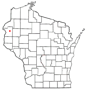
Georgetown is a town in Polk County, Wisconsin, United States. The population was 977 at the 2010 census. The unincorporated communities of Bunyan and Fox Creek are located in the town.

Whitewater is a town in Walworth County, Wisconsin, United States. The population was 1,433 at the 2020 census.

Lowell is a town in Dodge County, Wisconsin, United States. The population was 1,169 at the 2000 census. The Village of Lowell and the unincorporated community of North Lowell are located in the town.

<span class="mw-page-title-main">Boscobel (town), Wisconsin</span> Town in Wisconsin, United States

Boscobel is a town in Grant County, Wisconsin, United States. The population was 433 at the 2000 census. The town borders the city of Boscobel.

<span class="mw-page-title-main">Hammond, Wisconsin</span> Village in Wisconsin, United States

Hammond is a village in St. Croix County, Wisconsin, United States. The population was 1,922 at the 2010 census. The village is located within the Town of Hammond. Hammond was home to the Running of the Llamas.

References

  1. 1 2 "US Board on Geographic Names". United States Geological Survey. October 25, 2007. Retrieved January 31, 2008.
  2. 1 2 "U.S. Census website". United States Census Bureau . Retrieved January 31, 2008.
  3. 1 2 "Geographic Identifiers: 2010 Demographic Profile Data (G001): Holland town, Brown County, Wisconsin". U.S. Census Bureau, American Factfinder. Archived from the original on February 12, 2020. Retrieved May 12, 2014.

44°14′55″N88°10′18″W / 44.24861°N 88.17167°W / 44.24861; -88.17167