Glenmore, Wisconsin

Last updated

Glenmore, Wisconsin
Brown County Wisconsin incorporated and unincorporated areas Glenmore highlighted.svg
Location in Brown County and the state of Wisconsin.
Coordinates: 44°22′23″N87°56′42″W / 44.37306°N 87.94500°W / 44.37306; -87.94500
Country Flag of the United States.svg  United States
State Flag of Wisconsin.svg  Wisconsin
County Brown
Area
[1]
  Total32.8 sq mi (85.1 km2)
  Land32.8 sq mi (85.0 km2)
  Water0.0 sq mi (0.1 km2)
Elevation
[2]
912 ft (278 m)
Population
 (2020) [3]
  Total1,045
  Density31.8/sq mi (12.3/km2)
Time zone UTC-6 (Central (CST))
  Summer (DST) UTC-5 (CDT)
Area code 920
FIPS code 55-29550 [4]
GNIS feature ID1583285 [2]
Website glenmorewisconsin.org

Glenmore is a town in Brown County in the U.S. state of Wisconsin. The population was 1,045 at the 2020 census. [3]

Contents

Communities

Geography

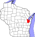
The Town of Glenmore, in Brown County, is located in Northeastern Wisconsin, approximately 10 miles southeast of Green Bay. Glenmore is primarily an agricultural community. According to the United States Census Bureau, the town has a total area of 32.8 square miles (85.0 km2), of which 0.023 square miles (0.06 km2), or 0.07%, is water. [5]

Demographics

As of the census [4] of 2000, there were 1,187 people, 375 households, and 322 families residing in the town. The population density was 36.3 people per square mile (14.0/km2). There were 382 housing units at an average density of 11.7 per square mile (4.5/km2). The racial makeup of the town was 99.33% White, 0.34% Asian, 0.08% Pacific Islander, and 0.25% from two or more races. Hispanic or Latino of any race were 0.51% of the population.

There were 375 households, out of which 45.6% had children under the age of 18 living with them, 76.8% were married couples living together, 4.5% had a female householder with no husband present, and 14.1% were non-families. 10.7% of all households were made up of individuals, and 4.0% had someone living alone who was 65 years of age or older. The average household size was 3.17 and the average family size was 3.41.

In the town, the population was spread out, with 31.8% under the age of 18, 8.4% from 18 to 24, 30.7% from 25 to 44, 20.8% from 45 to 64, and 8.3% who were 65 years of age or older. The median age was 33 years. For every 100 females, there were 105.4 males. For every 100 females age 18 and over, there were 103.5 males.

The median income for a household in the town was $51,466, and the median income for a family was $52,200. Males had a median income of $33,333 versus $22,262 for females. The per capita income for the town was $19,487. About 2.9% of families and 2.7% of the population were below the poverty line, including 4.7% of those under age 18 and none of those age 65 or over.

Economy

The wind farm Shirley Wind is located in the town, in the community of Shirley. [6]

Related Research Articles

<span class="mw-page-title-main">Vincent, Alabama</span> City in Alabama, United States

Vincent, originally known as Propel, is a city in Shelby, St. Clair, and Talladega counties in the U.S. state of Alabama. At the 2020 census, the population was 1,982. The community was first known as Propel, but later named Vincent in honor of the Vincent family, who were early settlers of the area. It was incorporated in 1897.

<span class="mw-page-title-main">Shirley, Indiana</span> Town in Indiana, United States

Shirley is a town in Brown Township, Hancock County and Greensboro Township, Henry County, Indiana, United States. The population was 830 at the 2010 census.

<span class="mw-page-title-main">Holland, Brown County, Wisconsin</span> Town in Wisconsin, United States

Holland is a town in Brown County in the U.S. state of Wisconsin. The population was 1,519 at the 2010 census. The unincorporated communities of Askeaton and Hollandtown are located in the town.

<span class="mw-page-title-main">Humboldt, Wisconsin</span> Town in Wisconsin, United States

Humboldt is a town in Brown County in the U.S. state of Wisconsin. The population was 1,311 at the 2010 census. The community name was chosen by Henry Fontaine.

<span class="mw-page-title-main">Ledgeview, Wisconsin</span> Town in Wisconsin, United States

Ledgeview is a town in Brown County in the U.S. state of Wisconsin. The population was 6,555 as of the 2010 census, up from 3,363 at the 2000 census.

<span class="mw-page-title-main">Morrison, Wisconsin</span> Town in Wisconsin, United States

Morrison is a town in Brown County in the U.S. state of Wisconsin. The population was 1,599 at the 2010 census.

<span class="mw-page-title-main">Pittsfield, Wisconsin</span> Town in Wisconsin, United States

Pittsfield is a town in Brown County in the U.S. state of Wisconsin. The population was 2,608 at the 2010 census.

<span class="mw-page-title-main">Rockland, Brown County, Wisconsin</span> Town in Wisconsin, United States

Rockland is a town in Brown County in the U.S. state of Wisconsin. The population was 1,734 at the 2010 census.

<span class="mw-page-title-main">Scott, Brown County, Wisconsin</span> Town in Wisconsin, United States

Scott is a town in Brown County in the U.S. state of Wisconsin. As of the 2020 census, the population was 3,636.

<span class="mw-page-title-main">Dewhurst, Wisconsin</span> Town in Wisconsin, United States

Dewhurst is a town in Clark County in the U.S. state of Wisconsin. The population was 323 at the 2010 census. The ghost town of Trow was located in the town.

<span class="mw-page-title-main">Fern, Wisconsin</span> Town in Wisconsin, United States

Fern is a town in Florence County, Wisconsin, United States. The population was 153 at the 2000 census.

<span class="mw-page-title-main">Curran, Wisconsin</span> Town in Wisconsin, United States

Curran is a town in Jackson County, Wisconsin, United States. The population was 343 at the 2010 census.

<span class="mw-page-title-main">Cold Spring, Wisconsin</span> Town in Wisconsin, United States

Cold Spring is a town in Jefferson County, Wisconsin, United States. The population was 727 in the recent 2010 census.

<span class="mw-page-title-main">Franklin, Kewaunee County, Wisconsin</span> Town in Wisconsin, United States

Franklin is a town in Kewaunee County, Wisconsin, United States. The population was 993 at the 2010 census.

<span class="mw-page-title-main">Montpelier, Wisconsin</span> Town in Wisconsin, United States

Montpelier is a town in Kewaunee County, Wisconsin, United States. The population was 1,306 at the 2010 census.

<span class="mw-page-title-main">Day, Wisconsin</span> Town in Wisconsin, United States

Day is a town in southwest Marathon County, Wisconsin, United States. It is part of the Wausau, Wisconsin Metropolitan Statistical Area. The population was 1,085 at the 2010 census. The unincorporated community of Rozellville is located in the town. The unincorporated community of Rangeline is also located partially in the town.

<span class="mw-page-title-main">Wien, Wisconsin</span> Town in Wisconsin, United States

Wien is a town in Marathon County, Wisconsin, United States. It is part of the Wausau, Wisconsin Metropolitan Statistical Area. The population was 825 at the 2010 census. The unincorporated community of Wien is located in the town.

<span class="mw-page-title-main">Spruce, Wisconsin</span> Town in Wisconsin, United States

Spruce is a town in Oconto County, Wisconsin, United States. The population was 835 at the 2010 census.

<span class="mw-page-title-main">Norway, Wisconsin</span> Town in Wisconsin, United States

The Town of Norway is located in Racine County, Wisconsin, United States. The population was 7,916 at the 2020 census. The census-designated place of Wind Lake is in the town. The unincorporated communities of North Cape and Union Church are also located partially in the town.

Bar Harbor is a census-designated place (CDP) in the town of Bar Harbor in Hancock County, Maine, United States. The CDP population was 2,552 at the 2010 census, out of a population of 5,235 in the town of Bar Harbor as a whole.

References

  1. "2020 U.S. Gazetteer Files". United States Census Bureau. Retrieved March 22, 2024.
  2. 1 2 "US Board on Geographic Names". United States Geological Survey. October 25, 2007. Retrieved January 31, 2008.
  3. 1 2 "Profile of General Population and Housing Characteristics: 2020 Demographic Profile Data (DP-1): Glenmore town, Brown County, Wisconsin". United States Census Bureau . Retrieved March 22, 2024.
  4. 1 2 "U.S. Census website". United States Census Bureau . Retrieved January 31, 2008.
  5. "Geographic Identifiers: 2010 Demographic Profile Data (G001): Glenmore town, Brown County, Wisconsin". U.S. Census Bureau, American Factfinder. Archived from the original on February 12, 2020. Retrieved May 12, 2014.
  6. Brown County Wind Turbine Battle Archived June 7, 2015, at the Wayback Machine

44°23′09″N87°55′38″W / 44.38583°N 87.92722°W / 44.38583; -87.92722