
Shawano County is a county located in the U.S. state of Wisconsin. As of the 2010 census, the population was 41,949. Its county seat is Shawano.

Outagamie is a county in the northeast region of the U.S. state of Wisconsin. As of the 2010 census, the population was 176,695. Its county seat is Appleton.
US Highway 141 (US 141) is a north–south United States Numbered Highway in the states of Wisconsin and Michigan. The highway runs north-northwesterly from an interchange with Interstate 43 (I-43) in Bellevue, Wisconsin, near Green Bay, to a junction with US 41/M-28 near Covington, Michigan. In between, it follows city streets in Green Bay and has a concurrent section with US 41 in Wisconsin. North of Green Bay, US 141 is either a freeway or an expressway into rural northern Wisconsin before downgrading to an undivided highway. In Michigan, US 141 is an undivided highway that runs through rural woodlands. The highway has two segments in each state; after running through Wisconsin for about 103 miles (166 km), it crosses into Michigan for approximately another 8 miles (13 km). After that, it crosses back into Wisconsin for about 14 1⁄2 miles (23 km) before crossing the state line one last time. The northernmost Michigan section is about 43 1⁄2 miles (70 km), making the overall length about 169 miles (272 km).
U.S. Highway 8 (US 8) is a United States Numbered Highway that runs primarily east–west for 280 miles (451 km), mostly within the state of Wisconsin. It connects Interstate 35 (I-35) in Forest Lake, Minnesota, to US 2 at Norway in the Upper Peninsula of Michigan near the border with Wisconsin. Except for the short freeway segment near Forest Lake, and sections near the St. Croix River bridge and Rhinelander, Wisconsin, it is mostly undivided surface road. As a state highway in the three states, US 8 is maintained by the Minnesota, Wisconsin and Michigan departments of transportation.
Interstate 41 (I-41) is a 176.33-mile-long (283.78 km) Interstate Highway connecting the interchange of I-94 and U.S. Route 41, located 0.9 miles (1.4 km) south of the Wisconsin–Illinois border at the end of the Tri-State Tollway in metropolitan Chicago, to an interchange with I-43 in metropolitan Green Bay, Wisconsin. The designation travels concurrently with US 41, I-894, US 45, I-43, and sections of I-94 in Wisconsin and Illinois. The route was officially added to the Interstate Highway System on April 7, 2015, and connects Milwaukee and the Fox Cities with Green Bay.
State Trunk Highway 172 is a state highway in the U.S. state of Wisconsin. It is a freeway from Interstate 41 (I-41) / U.S. Highway 41 to I-43, providing a southern bypass of Green Bay. West of I-41/US-41, it continues as a surface road past the Austin Straubel International Airport towards Highway 54.
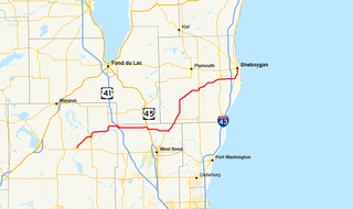
State Trunk Highway 28 is a state highway in the U.S. state of Wisconsin. It runs east–west in southeastern Wisconsin between Horicon and Sheboygan. The route is 59.77 miles (96.19 km) long and is generally two-lane road beyond portions of the road within the city of Sheboygan and the half-mile portion of the highway near Waldo which is concurrent with STH 57.

State Trunk Highway 111 is a state highway in the U.S. state of Wisconsin. It runs from U.S. Route 8 near Catawba north to Highway 13 south of Phillips. The highway is located entirely within Price County. Highway 111 is maintained by the Wisconsin Department of Transportation.
State Trunk Highway 125 is a 2.62-mile (4.22 km) state highway in Outagamie County in the U.S. state of Wisconsin. It runs from Interstate 41 in the Town of Grand Chute east to Wisconsin Highway 47 in Appleton; the route is located entirely within these two municipalities. Highway 125 is maintained by the Wisconsin Department of Transportation.
State Trunk Highway 156 is a 26.72-mile (43.00 km) state highway in the U.S. state of Wisconsin. The highway runs east–west through northeast Wisconsin, passing through Waupaca and Shawano counties. Highway 156 runs from Wisconsin Highway 22 in Clintonville east to Wisconsin Highway 29 at the Brown County line northwest of Green Bay. The highway is maintained by the Wisconsin Department of Transportation.

Greenleaf is an unincorporated census-designated place in Brown County, Wisconsin, United States, in the town of Wrightstown. As of the 2010 census it had a population of 607. Greenleaf was named for Emery B. Greenleaf, the general manager of the Milwaukee & Northern railroad at the time the Greenleaf post office was established in 1873.
Eleven special routes of U.S. Route 151 exist. Three of which are located in Iowa and the other eight are in Wisconsin.

Poland is an unincorporated community in the Town of Eaton, Brown County, Wisconsin, United States. It is located at the intersection of County Highway T and Wisconsin Highway 29 several miles east of Green Bay. It is located at latitude 44-26-37N and longitude 87-49-34W.

Minnesota Junction is an unincorporated community located, in the town of Oak Grove, in Dodge County, Wisconsin, United States. Minnesota Junction is located on Wisconsin Highway 26. It is located at latitude 43.452 and longitude -88.697 at 925 feet above mean sea level.
Askeaton is an unincorporated community located in the town of Holland, Brown County, Wisconsin, United States. Askeaton is located southeast of Wrightstown at the intersection of County Z and St. Pat's Church Road. The town hall for the Town of Holland is located in Askeaton.

County Line is an unincorporated community located on the border of Marinette and Oconto counties, in the U.S. state of Wisconsin. The Marinette County portion of the community is located in the town of Grover, while the Oconto County portion is located in the town of Little River. County Line is located on County Trunk Highway W near U.S. Highway 41, 6.5 miles (10.5 km) southwest of Peshtigo.
Henrysville is an unincorporated community in the Town of Eaton, Brown County, Wisconsin, United States. It is located at the junction of Wisconsin Highway 29 and County Highway P 12 miles (19 km) east-southeast of Green Bay. In May of 1879, John Henry Osterloh opened a post office in the community.

Brockway is an unincorporated community located in the town of Brockway, Jackson County, Wisconsin, United States. It is located at the intersection of U.S. Route 12 and Wisconsin Highway 27 and shares its northern border with Black River Falls, Wisconsin.
Coppens Corner is an unincorporated community in the Town of Eaton, Brown County, Wisconsin, United States.


