Sevastopol is a town in Door County, Wisconsin, United States. The population was 2,667 at the 2000 census.

Meeme is a town in Manitowoc County, Wisconsin, United States. The population was 1,538 at the 2000 census. Its Menominee name is Omīnīw which means "pigeon". The Menominee sold this land to the United States in the 1831 Treaty of Washington.

Newton is a town in Manitowoc County, Wisconsin, United States. The population was 2,241 at the 2000 census.
Greenville is a village in Outagamie County, Wisconsin. It is one of 18 communities that form the basis of the Fox Cities, the third largest metropolitan area in Wisconsin. The population was 12,619 in 2020.

Phelps is a town in Vilas County, Wisconsin, United States. The population was 1,238 in 2020. The unincorporated community of Phelps is located in the town.

State Trunk Highway 15 is a 14.8-mile (23.8 km)state highway in Outagamie County in the US state of Wisconsin that runs east–west and provides a shortcut to Appleton from U.S. Highway 45 (US 45) for travelers inbound from points north and west. Most of WIS 15 was once part of US 45, which was redirected south of New London to bypass Appleton and provide direct access to Oshkosh and points south.
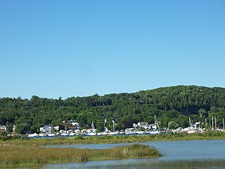
Fish Creek is an unincorporated community located in Door County, Wisconsin, United States, within the town of Gibraltar. It is located on Highway 42 along Green Bay.

State Trunk Highway 76 is a state highway in the U.S. state of Wisconsin. It runs north–south in east central Wisconsin from US Highway 45 near Bear Creek to a junction with US Highway 45 in downtown Oshkosh.

State Trunk Highway 122 is a 14.69-mile-long (23.64 km) state highway in the US state of Wisconsin. It runs north–south from WIS 77 in Upson to the Michigan border near Saxon; the route is located entirely within Iron County. WIS 122 is maintained by the Wisconsin Department of Transportation (WisDOT).

Greenleaf is a village in Brown County, Wisconsin, United States, in the town of Wrightstown.

Peebles, Wisconsin is an unincorporated community in the Town of Taycheedah in Fond du Lac County, Wisconsin. The community is located adjacent to the unincorporated community of Taycheedah. U.S. Route 151 runs through the community. Wisconsin Highway 149 used to run through the community at its western terminus until it was decommissioned in 2006. Taycheedah Correctional Institution is located in the town of Taycheedah several miles south of the community.
Stephensville is a small unincorporated community located entirely within the town of Ellington in west-central Outagamie County, Wisconsin, United States. Stephensville is classified as a Class U6 Community by the USGS, being a populated place located wholly or substantially outside the boundaries of any incorporated place or CDP with a recognized authoritative common name.

Alaska is an unincorporated community located on Wisconsin Highway 42 in the town of Pierce, Kewaunee County, Wisconsin. Alaska falls between East Alaska Lake and West Alaska Lake and is an important tourist and fishing spot. As well as home to Troop 3 Alaska in the area, it is also home to the Alaskan Golf Club, a public course located on East Alaska Lake.
Mather is an unincorporated community in the town of Kingston in Juneau County, Wisconsin, United States. It is located on Wisconsin Highway 173 (WIS 173) 16 miles (26 km) northeast of Tomah. Mather has a post office with ZIP code 54641.

Woodland is an unincorporated community located, in the towns of Herman and Rubicon, in Dodge County, Wisconsin, United States. It is located at the intersection of Wisconsin Highway 67 and County highway WS.

Poland is an unincorporated community in the Town of Eaton, Brown County, Wisconsin, United States. It is located at the intersection of County Highway T and Wisconsin Highway 29 several miles east of Green Bay. It is located at latitude 44-26-37N and longitude 87-49-34W. Poland was named for and by the many Polish immigrants that settled in the area during the 1870's. In 1881, community members built SS. Cyril and Methodius Catholic Church in the heart of Poland. The church was destroyed by fire in 1898, and a new church was constructed the following year.

Florence is a census-designated place in and the county seat of Florence County, Wisconsin, United States. Florence is located in northern Florence County, in the town of Florence. Florence has a post office with ZIP code 54121. The community was named a census-designated place in 2010. As of the 2010 census, its population was 592.

Burnett is an unincorporated census-designated place located in the town of Burnett, Dodge County, Wisconsin, United States. Burnett is located on Wisconsin Highway 26 5.5 miles (8.9 km) northwest of Horicon. Burnett has a post office with ZIP code 53922. As of the 2010 census, its population is 256.

Landstad is an unincorporated community located in the town of Lessor, Shawano County, Wisconsin, United States. Landstad is located on Wisconsin Highway 47 5.5 miles (8.9 km) south of Bonduel. The Landstad post office was established by its first postmaster, Sven G. Morgan, in June 1882. The community was likely named for Magnus Brostrup Landstad, a popular poet and hymnal writer at the time.

Brockway is an unincorporated community located in the town of Brockway, Jackson County, Wisconsin, United States. It is located at the intersection of U.S. Route 12 and Wisconsin Highway 27 and shares its northern border with Black River Falls, Wisconsin.


