Isaar, Wisconsin

Last updated

Isaar, Wisconsin
Downtown Isaar 09.JPG
Downtown Isaar (facing North on Isaar Rd)
USA Wisconsin location map.svg
Red pog.svg
Isaar, Wisconsin
Usa edcp location map.svg
Red pog.svg
Isaar, Wisconsin
Coordinates: 44°34′18″N88°17′4″W / 44.57167°N 88.28444°W / 44.57167; -88.28444
Country Flag of the United States.svg  United States
State Flag of Wisconsin.svg  Wisconsin
County Outagamie
Area
  Total1 km2 (0.4 sq mi)
  Land1 km2 (0.4 sq mi)
  Water0 km2 (0.0 sq mi)
Elevation
239 m (784 ft)
Population
  Total200 (Estimated)
Time zone UTC-6 (Central (CST))
  Summer (DST) UTC-5 (CDT)
Website Isaar Booster Club

Isaar is a small unincorporated community in the Town of Seymour in Outagamie County, the United States, about 10 miles from Green Bay. [1] Isaar has the same zip code as the City of Seymour and its schools are part of the Seymour Community School District.

Contents

Isaar was founded in 1867 by immigrants from Bavaria who settled there as part of the Homestead Act. The town was named by the new settlers after the Isar River in their homeland. Isaar became known for its St. Sebastian Catholic Church, [2] although in September 2007 the last resident priest left Isaar.

The community is home to a number of clubs, such as the snowmobile club, called the Isaar Trail Riders, and the Isaar Booster Club. The downtown area of Isaar is located at the intersection of County Hwy VV and Isaar Road. Isaar has always been known as a small farming community and continues this tradition today. Today the community has a tavern/restaurant, a construction company, a food processing plant, and a nursery, as well as few other businesses within its business district.

Transportation

County Highway VV, running east–west, is the main road that connects Isaar to other larger state highways. There are also snowmobile trails that run through the community.

Geography

Isaar is located at 44°34′18″N88°17′04″W / 44.57167°N 88.28444°W / 44.57167; -88.28444 (44.57167, -88.28444), [3] at an elevation of 830 feet (250 m).

The land around Isaar is flat and very fertile. This makes it an excellent choice for growing cabbage and corn in the area. There are multiple creeks that run through the area, often man-made creeks to prevent flooding and to keep the run-off from damaging the fields.

History of Isaar

Isaar is located in the northeastern corner of the Town of Seymour. Named after the Isar River, in Germany, the community was founded in the late 1860s by Bavarian immigrants. The town's founding families included Kroner, Hackl, Ebert, Liebhabers, Krause, Wirth, Schmidt, Brugger, Hartl, and Noll.

In 1893, the Isaar community's request for a church was granted by the Roman Catholic Bishop of the Diocese of Green Bay, Sebastian Gebhard Messmer. St. Sebastian Church, named in honour of Bishop Messmer's patron saint, was a wooden building constructed by Isaar citizens on John Kroner's land, which is believed to have been donated. This church was completed in 1893 at a cost of $100. A cemetery was established north of the church two years later. The rectory was constructed in 1916 and the Isaar church was no longer a mission. In late December 1929, a fire destroyed the original church. The brick church that stands today was built shortly after the wooden church burned down. It was built by the Eisenreich Construction Company of Isaar.

Ebert's Store, which was the general store, grocery store, saloon and dance hall, was constructed in 1900 and is today the Isaar Inn. South of Ebert's store was the blacksmith shop, built in the 1890s. Isaar's First School was built one mile north of Isaar in 1898, now known as Seymour School District No.7. In 1902 a tavern was opened by John Kroner to the north of the church cemetery. A sawmill was opened, by John Schmidt and Henry Wirth, 200 feet east of Kroner's Tavern in 1908. The first cheese factory was built in 1890 by Jacob Noll just a mile north of Isaar. In 1918 a cooperative cheese factory was begun by Isaar farmers. This factory, which is just north of the Isaar Inn, was operational until 1993. [4]

History of Church and Community Events

St. Sebastian church had at one time an annual church picnic where all parish members could spend the day playing baseball and other games. St. Sebastian was also known for its locally famous "Annual Porky and Pancake Supper". [5] This event was run by community volunteers and brought in revenue for the church youth organization. It was known for its potato pancakes, a favourite meal of the Isaar community. In 2002 St. Sebastian Church hosted the 50th anniversary of this event, which was the last Porky and Pancake Supper Isaar hosted. Low volunteer turnout has been attributed to the collapse of this event.

Related Research Articles

<span class="mw-page-title-main">Outagamie County, Wisconsin</span> County in Wisconsin

Outagamie County is a county in the Fox Cities region of the U.S. state of Wisconsin, located in the northeast of the state. As of the 2020 Census, the population was 190,705. Its county seat is Appleton.

<span class="mw-page-title-main">Coventry, Connecticut</span> Town in Connecticut, United States

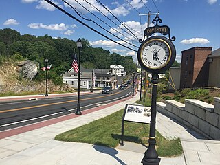
Coventry is a town in the Capitol Planning Region, Connecticut. The population was 12,235 at the 2020 census. The birthplace of Captain Nathan Hale, Coventry is home to the Nathan Hale Homestead, which is now a museum open to the public. Coventry was incorporated in May 1712.

<span class="mw-page-title-main">Ellenville, New York</span> Village in New York, United States

Ellenville is a village within the town of Wawarsing, Ulster County, New York, United States. Its population was 4,167 at the 2020 census.

<span class="mw-page-title-main">Shiocton, Wisconsin</span> Village in Wisconsin, United States

Shiocton is a village in Outagamie County, Wisconsin, United States. The population was 921 at the 2010 census. It is wholly surrounded by the Town of Bovina.

<span class="mw-page-title-main">New London, Wisconsin</span> City in Wisconsin, United States

New London is a city in Outagamie and Waupaca counties Wisconsin, United States. Founded in 1851, the population was 7,295 at the 2010 census. Of this, 5,685 were in Waupaca County, and 1,640 were in Outagamie County.

<span class="mw-page-title-main">Black Creek, Wisconsin</span> Village in Wisconsin, United States

Black Creek is a village in north-central Outagamie County, Wisconsin, United States. The population was 1,357 at the 2020 census. The village is located within the Town of Black Creek, but is governed independently. Origins of the community trace back to 1862 when it was settled by American Civil War veteran, Thomas J. Burdick and his son, Abraham. Initially, the village had been referred to as Middleburg, due to its geographical proximity to Green Bay, Shawano, and Appleton. However, the name was later changed to reflect the dark-colored creek along the outskirts of the community following village incorporation in 1904. Today, Black Creek hosts a variety of community events including the annual Family Daze celebration.

<span class="mw-page-title-main">Roman Catholic Archdiocese of Milwaukee</span> Latin Catholic ecclesiastical jurisdiction in Wisconsin, USA

The Archdiocese of Milwaukee is a Latin Church ecclesiastical territory, or archdiocese, of the Catholic Church in southeast Wisconsin in the United States.

<span class="mw-page-title-main">Strand, London</span> Major thoroughfare in the City of Westminster, London, England

Strand is a major thoroughfare in the City of Westminster, Central London. The street, which is part of London's West End theatreland, runs just over 34 mile (1.2 km) from Trafalgar Square eastwards to Temple Bar, where the road becomes Fleet Street in the City of London, and is part of the A4, a main road running west from inner London.

<span class="mw-page-title-main">Longyearbyen</span> Largest settlement and administrative centre of Svalbard, Norway

Longyearbyen is the world's northernmost settlement with a population greater than 1,000, and the largest inhabited area of Svalbard, Norway. It stretches along the foot of the left bank of the Longyear Valley and on the shore of Adventfjorden, the short estuary leading into Isfjorden on the west coast of Spitsbergen, the island's broadest inlet. As of 2002 Longyearbyen Community Council became an official Norwegian municipality. It is the seat of the Governor of Svalbard. The town's mayor is Arild Olsen.

<span class="mw-page-title-main">Pietro Perugino</span> Italian Renaissance painter (c. 1446/1452–1523)

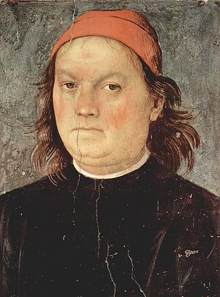
Pietro Perugino, born Pietro Vannucci, was an Italian Renaissance painter of the Umbrian school, who developed some of the qualities that found classic expression in the High Renaissance. Raphael was his most famous pupil.

<span class="mw-page-title-main">Hoggs Hollow</span> Neighbourhood in Toronto, Ontario, Canada

Hoggs Hollow is a residential neighbourhood in Toronto, Ontario, Canada. It is located to the south of York Mills Road, east of Yonge Street, and the western branch of the upper Don River flows through it.

<span class="mw-page-title-main">Farran's Point, Ontario</span> Ghost Town in Ontario, Canada

Farran's Point is an underwater ghost town in the province of Ontario, Canada. It is one of Ontario's Lost Villages, which were permanently flooded by the creation of the St. Lawrence Seaway in 1958.

<span class="mw-page-title-main">Old Salem</span> Historic district in North Carolina, United States

Old Salem is a historic district of Winston-Salem, North Carolina, United States, which was originally settled by the Moravian community in 1766. It features a living-history museum which interprets the restored Moravian community. The non-profit organization began its work in 1950, although some private residents had restored buildings earlier. As the Old Salem Historic District, it was declared a National Historic Landmark (NHL) in 1966, and expanded fifty years later. The district showcases the culture of the Moravian settlement in the Province of North Carolina during the colonial 18th century and post-statehood 19th century via its communal buildings, churches, houses and shops.

<span class="mw-page-title-main">Augusta, Ontario</span> Township in Ontario, Canada

Augusta Township is a township in the United Counties of Leeds and Grenville, located in eastern Ontario, Canada. Augusta is situated along the Saint Lawrence River, and extends back into rural hamlets. The township is located between the city of Brockville to the west, and the town of Prescott to the east.

<span class="mw-page-title-main">Roman Catholic Diocese of Green Bay</span> Latin Catholic ecclesiastical jurisdiction in Wisconsin, USA

The Roman Catholic Diocese of Green Bay is a Latin church diocese in the northeast region of Wisconsin in the United States. It is a suffragan diocese of the Archdiocese of Milwaukee. Its mother church is the Cathedral of Saint Francis Xavier in Green Bay.

Woodville is a community in Kawartha Lakes, Ontario, Canada. It is located west of Lindsay. The population is 718 (2021).

<span class="mw-page-title-main">Maitland, Ontario</span> Village in Ontario, Canada

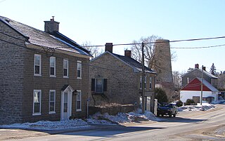
Maitland, Ontario is a small village within Augusta township in the United Counties of Leeds and Grenville, Canada. It is located along the St. Lawrence River approximately five kilometres (3 mi) east of the City of Brockville.

<span class="mw-page-title-main">Cathedral of St Michael and St George, Aldershot</span> Church in Hampshire, England

Cathedral Church of St Michael and St George serves as the Roman Catholic cathedral for the Bishopric of the Forces. Located on Queens Avenue in Aldershot, England, the building was originally intended to be the principal church for the Anglican chaplaincies of the British Army but since 1973 it has been the seat of the Roman Catholic Bishop of the Forces.

<span class="mw-page-title-main">Stone Mills</span> Township in Ontario, Canada

Stone Mills is a lower-tier township north of Greater Napanee in Lennox and Addington County, Ontario, Canada. According to the 2016 census, the township has a population of 7,702.

<span class="mw-page-title-main">Maribo Cathedral</span> Church in Lolland, Denmark

Maribo Cathedral is a Lutheran cathedral church built in the Gothic style in Maribo on the island of Lolland in the southeast of Denmark. It was originally part of Maribo Abbey which was founded in the early 15th century. The chancel, the oldest section of the cathedral, probably dates from 1416. The plan of the church is unusual in that the chancel is at the west end of the building rather than the east as a result of the design instructions left by Saint Bridget.

References

  1. "Isaar, Wisconsin". Geographic Names Information System . United States Geological Survey, United States Department of the Interior.
  2. Archived October 5, 2006, at the Wayback Machine
  3. "US Gazetteer files: 2010, 2000, and 1990". United States Census Bureau. February 12, 2011. Archived from the original on May 27, 2002. Retrieved April 23, 2011.
  4. Charles Ebert and Seymour Community Museum & Historical Society
  5. "The Compass newspaper - Calendar of Events". Thecompassnews.org. Retrieved December 18, 2011.