Parts of this article (those related to demographics) need to be updated.(March 2018) |
Hortonia, Wisconsin | |
---|---|
Coordinates: 44°21′35″N88°41′50″W / 44.35972°N 88.69722°W | |
Country | United States |
State | Wisconsin |
County | Outagamie |
Area | |
• Total | 19.4 sq mi (50.3 km2) |
• Land | 19.2 sq mi (49.7 km2) |
• Water | 0.2 sq mi (0.6 km2) |
Elevation | 840 ft (256 m) |
Population (2010) | |
• Total | 1,097 |
• Density | 55.4/sq mi (21.4/km2) |
Time zone | UTC-6 (Central (CST)) |
• Summer (DST) | UTC-5 (CDT) |
FIPS code | 55-35825 [2] |
GNIS feature ID | 1583410 [1] |
Website | http://www.townofhortonia.org |
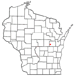
Hortonia is a town in Outagamie County, Wisconsin, United States. The population was 1,097 at the 2010 census.
According to the United States Census Bureau, the town has a total area of 19.4 square miles (50.3 km2), of which, 19.2 square miles (49.7 km2) of it is land and 0.2 square miles (0.6 km2) of it (1.18%) is water.
As of the census [2] of 2010, there were 1,097 people, 362 households, and 296 families residing in the town. The population density was 55.4 people per square mile (21.4/km2). There were 375 housing units at an average density of 19.5 per square mile (7.5/km2). The racial makeup of the town was 98.49% White, 0.66% Native American, 0.28% Asian, 0.19% from other races, and 0.38% from two or more races. Hispanic or Latino of any race were 0.56% of the population.
There were 362 households, out of which 38.4% had children under the age of 18 living with them, 76.2% were married couples living together, 3.3% had a female householder with no husband present, and 18.0% were non-families. 14.6% of all households were made up of individuals, and 5.8% had someone living alone who was 65 years of age or older. The average household size was 2.83 and the average family size was 3.13.
In the town, the population was spread out, with 27.3% under the age of 18, 6.0% from 18 to 24, 32.6% from 25 to 44, 25.2% from 45 to 64, and 8.8% who were 65 years of age or older. The median age was 37 years. For every 100 females, there were 103.3 males. For every 100 females age 18 and over, there were 103.4 males.
The median income for a household in the town was $59,904, and the median income for a family was $66,705. Males had a median income of $46,307 versus $25,938 for females. The per capita income for the town was $29,573. About 1.4% of families and 6.4% of the population were below the poverty line, including 3.1% of those under age 18 and 5.7% of those age 65 or over.
Amboy is a town in Jackson Township, Miami County, in the U.S. state of Indiana. The population was 317 at the 2020 census, down from 384 in 2010.
Lynn is a town in Washington Township, Randolph County, in the U.S. state of Indiana. The population was 1,097 at the 2010 census.
Hazleton is a city in Buchanan County, Iowa, United States. The population was 713 at the time of the 2020 census.
Treynor is a city in Pottawattamie County, Iowa, United States. The population was 1,032 as of the 2020 census.
Greenwood is a town in Oxford County, Maine, United States. The population was 774 at the 2020 census. The town was named for surveyor Alexander Greenwood. The village of Locke Mills, on State Route 26 in the northern part of Greenwood, is the town's urban center and largest settlement.
Carmel is a town in Penobscot County, Maine, United States. It is part of the Bangor Metropolitan Statistical Area. The population was 2,867 at the 2020 census.
Detroit is a town in Somerset County, Maine, United States. The population was 885 at the 2020 census.
Perry is a town in Washington County, Maine, United States, on the Canada–United States border. At the 2020 census, the town had a population of 802.
Rutland is a town in Jefferson County, New York, United States. The population was 3,038 at the 2020 census.
Curtisville is a census-designated place (CDP) in West Deer Township, Pennsylvania, United States. The population was 1,097 at the 2020 census.
Barry Township is a township in Schuylkill County, Pennsylvania. Formed in 1822, it is named for American Revolutionary War Commander John Barry and was formed from parts of Norwegian and Schuylkill Townships.
Franklin Township is a township in Susquehanna County, Pennsylvania, United States. The population was 833 at the 2020 census. Salt Springs State Park, a Pennsylvania state park, is in Franklin Township.
Granville is a town in Monongalia County, West Virginia, United States. The population was 1,355 at the 2020 census. It is included in the Morgantown metropolitan area.
Fall River is a village in Columbia County, Wisconsin, United States, along the North Fork of the Crawfish River. The population was 1,712 at the 2010 census. It is part of the Madison Metropolitan Statistical Area.
Marcellon is a town in Columbia County, Wisconsin, United States. The population was 1,024 at the 2000 census. The unincorporated community of Belle Fountain is located in the town.
Medina is a town in Dane County, Wisconsin, United States. The population was 1,235 at the 2000 census. The unincorporated community of Deansville is located in the town.
Watterstown is a town in Grant County, Wisconsin, United States. The population was 362 at the 2000 census.
Richland is a town in Richland County, Wisconsin, United States. The population was 1,364 at the 2000 census.
Waukechon is a town in Shawano County, Wisconsin, United States. The population was 928 at the 2000 census. The unincorporated community of Lunds is located in the town. Its Menominee name is Wākecānāpāēw, meaning "crooked beak man", a reference to the Thunderbird Clan of the Ho-Chunk.
Helvetia is a town in Waupaca County, Wisconsin, in the United States. As of the 2000 census, the town population was 649.