Little Suamico, Wisconsin

Last updated

Little Suamico, Wisconsin
WIMap-doton-Little Suamico.png
Location of Little Suamico, Wisconsin
Coordinates: 44°42′55″N88°2′45″W / 44.71528°N 88.04583°W / 44.71528; -88.04583
Country Flag of the United States.svg  United States
State Flag of Wisconsin.svg  Wisconsin
County Oconto
Area
  Total37.4 sq mi (96.9 km2)
  Land37.3 sq mi (96.7 km2)
  Water0.1 sq mi (0.2 km2)
Elevation
[1]
633 ft (193 m)
Population
 (2020)
  Total5,536
  Density103.8/sq mi (40.1/km2)
Time zone UTC-6 (Central (CST))
  Summer (DST) UTC-5 (CDT)
Area code 920
FIPS code 55-45275 [2]
GNIS feature ID1583586 [1]
Website http://www.townoflittlesuamico.com

Little Suamico is a town in Oconto County, Wisconsin, United States. The population was 5536 at the 2020 census.

Contents

Communities

History

The earliest records for the town date to 1859, when Ernst Kuntze was the town chair, clerk, and treasurer. [4]

The town established a post office in 1858, but it was discontinued in 1899. 2 years later in 1901, the town established a post office that still operates today. [5]

Geography

According to the United States Census Bureau, the town has a total area of 37.4 square miles (96.9 km2), of which, 37.3 square miles (96.7 km2) of it is land and 0.1 square miles (0.2 km2) of it (0.16%) is water.

Demographics

The 2020 US Census lists the town's population at 5536. Up from 4799 in 2010.

As of the census [2] of 2000, there were 3,877 people, 1,358 households, and 1,106 families residing in the town. The population density was 103.8 people per square mile (40.1/km2). There were 1,403 housing units at an average density of 37.6 per square mile (14.5/km2). The racial makeup of the town was 97.86% White, 0.59% African American, 0.54% Native American, 0.26% Asian, 0.03% Pacific Islander, 0.26% from other races, and 0.46% from two or more races. Hispanic or Latino of any race were 0.80% of the population.

There were 1,358 households, out of which 42.3% had children under the age of 18 living with them, 71.1% were married couples living together, 6.1% had a female householder with no husband present, and 18.5% were non-families. 13.6% of all households were made up of individuals, and 4.1% had someone living alone who was 65 years of age or older. The average household size was 2.85 and the average family size was 3.14.

In the town, the population was spread out, with 30.0% under the age of 18, 5.9% from 18 to 24, 35.3% from 25 to 44, 23.3% from 45 to 64, and 5.5% who were 65 years of age or older. The median age was 35 years. For every 100 females, there were 104.7 males. For every 100 females age 18 and over, there were 103.7 males.

The median income for a household in the town was $60,160, and the median income for a family was $64,973. Males had a median income of $39,846 versus $30,213 for females. The per capita income for the town was $22,520. About 2.1% of families and 3.9% of the population were below the poverty line, including 3.4% of those under age 18 and 8.7% of those age 65 or over.

Related Research Articles

<span class="mw-page-title-main">Island Falls, Maine</span> Town in the state of Maine, United States

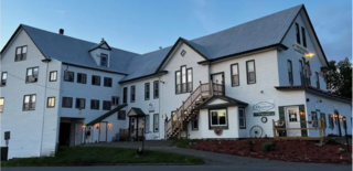
Island Falls is a town in Aroostook County, Maine, United States. The population was 758 at the 2020 census. The primary village of Island Falls in the town is situated at a falls in the West Branch Mattawamkeag River.

<span class="mw-page-title-main">Upton, Maine</span> Town in the state of Maine, United States

Upton is a town in Oxford County, Maine, United States. The population was 69 at the 2020 census.

<span class="mw-page-title-main">Fairbanks Township, Michigan</span> Civil township in Michigan, United States

Fairbanks Township is a civil township of Delta County in the U.S. state of Michigan. As of the 2020 census, the township population was 297, up from 281 at the 2010 census.

<span class="mw-page-title-main">Greenfield, Missouri</span> City in Missouri, United States

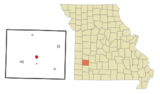
Greenfield is a city in Dade County, Missouri. The population was 1,220 at the 2020 census. It is the county seat of Dade County.

<span class="mw-page-title-main">Edgar, Nebraska</span> City in Nebraska, United States

Edgar is a city in Clay County, Nebraska, United States. The population was 498 at the 2010 census. It is part of the Hastings, Nebraska Micropolitan Statistical Area.

Wheatland Township is a township located in the northwest corner of Rice County, Minnesota, United States. The population was 1,358 at the 2000 census.

<span class="mw-page-title-main">Eaton, New York</span> Town in New York, United States

Eaton is a town in Madison County, New York, United States. The population was 4,284 at the 2020 census.

<span class="mw-page-title-main">Benton, New York</span> Town in New York, United States

Benton is a town in Yates County, New York, United States. The population was 2,836 at the 2010 census. The town is named after an early resident, Levi Benton (1746-1820)

<span class="mw-page-title-main">Richburg, South Carolina</span> Town in South Carolina, United States

Richburg is a town in Chester County, South Carolina, United States. The population was 275 at the 2010 census, down from 332 at the 2000 census.

<span class="mw-page-title-main">Mirrormont, Washington</span> Census-designated place in Washington, United States

Mirrormont is a census-designated place (CDP) in King County, Washington, United States, south of Issaquah. The population was 3,858 at the 2020 census. Within the last decade, the area has seen a shift in development as larger homes have been constructed in Cedar Grove, the Highlands at Tiger Mountain and Mirrormont.

<span class="mw-page-title-main">Garfield, Washington</span> Town in Washington, United States

Garfield is a city in Whitman County, Washington, United States. The population was 562 at the 2020 census.

<span class="mw-page-title-main">Suamico, Wisconsin</span> Village in Wisconsin, United States

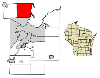
Suamico is a village in Brown County in the U.S. state of Wisconsin. The population was 12,820 at the time of the 2020 census. Suamico is part of the Green Bay Metropolitan Statistical Area, and contains the neighborhood community of Flintville.

<span class="mw-page-title-main">Bridgeport, Wisconsin</span> Town in Wisconsin, United States

Bridgeport is a town in Crawford County, Wisconsin, United States. The population was 946 at the 2000 census. The unincorporated community of Bridgeport is located in the town.

<span class="mw-page-title-main">How, Wisconsin</span> Town in Wisconsin, United States

How is a town in Oconto County, Wisconsin, United States. The population was 563 at the 2000 census. The unincorporated community of Hayes is located in the town. The town is named for Calvin F. How, Jr., an insurance and banking executive.

<span class="mw-page-title-main">Underhill, Wisconsin</span> Town in Wisconsin, United States

Underhill is a town in Oconto County, Wisconsin, United States. The population was 846 at the 2000 census.

Oneida is a town in Outagamie County, Wisconsin, United States. The population was 4,001 at the 2000 census. The unincorporated communities of Chicago Corners and Oneida are located in the town. The town occupies the Outagamie County portion of Wisconsin's Oneida Nation of Wisconsin.

<span class="mw-page-title-main">Tichigan, Wisconsin</span> Census-designated place in Wisconsin, United States

Tichigan is a census-designated place (CDP) in Racine County, Wisconsin, United States. The population was 5,277 at the 2020 census.

<span class="mw-page-title-main">Rock, Rock County, Wisconsin</span> Town in Wisconsin, United States

The Town of Rock is a located in Rock County, Wisconsin, United States. The population was 2,981 at the 2020 census. The unincorporated community of Afton is in the town.

<span class="mw-page-title-main">Brillion (town), Wisconsin</span>

Brillion is a town in Calumet County in the U.S. state of Wisconsin. The population was 1,486 at the 2010 census.

Olive Branch is an unincorporated census-designated place in Alexander County, Illinois, United States. It has a post office with the ZIP code 62969. Its population was 650 at the 2020 census.

References

  1. 1 2 "US Board on Geographic Names". United States Geological Survey. October 25, 2007. Retrieved January 31, 2008.
  2. 1 2 "U.S. Census website". United States Census Bureau . Retrieved January 31, 2008.
  3. ZIP Code Lookup
  4. Town of Little Suamico.
  5. "Post Offices by County - Postmaster Finder - Who we are - About.usps.com". about.usps.com. Retrieved July 7, 2024.

44°43′03″N88°00′33″W / 44.71750°N 88.00917°W / 44.71750; -88.00917