Oconto, Wisconsin

Last updated

Oconto, Wisconsin
City
Oconto County Courthouse.jpg
Oconto County Wisconsin Incorporated and Unincorporated areas Oconto Highlighted.svg
Location of Oconto in Oconto County, Wisconsin.
USA Wisconsin location map.svg
Red pog.svg
Oconto, Wisconsin
Location within the state of Wisconsin
Coordinates: 44°53′N87°52′W / 44.883°N 87.867°W / 44.883; -87.867
Country Flag of the United States.svg  United States
State Flag of Wisconsin.svg  Wisconsin
County Oconto
Government
  MayorMitchell Rice
Area
[1]
  Total7.14 sq mi (18.48 km2)
  Land6.79 sq mi (17.57 km2)
  Water0.35 sq mi (0.91 km2)
Population
 (2020) [2]
  Total4,609
  Density679.3/sq mi (262.3/km2)
Time zone UTC-6 (Central (CST))
  Summer (DST) UTC-5 (CDT)
ZIP codes
54153
Area code 920
FIPS code 55-59350
Website cityofoconto.com

Oconto is a city and county seat of Oconto County, Wisconsin, United States. The population was 4,609 at the 2020 census. It is part of the Green Bay Metropolitan Statistical Area. The city is located partially within the town of Oconto.

Contents

History

Oconto is home to Copper Culture State Park, which has remains dated to around 5000-6000 B.C. It is a burial ground of the Copper Culture Indians. This burial ground is considered to be the oldest cemetery in Wisconsin and one of the oldest in the nation. [3] Their descendants include the Menominee, who have lived here for thousands of years.

The first Europeans to come to the area were the French, who considered it to be part of New France. The French Jesuit, Roman Catholic priest, and missionary, Father Claude-Jean Allouez said the first Mass in Oconto on December 3, 1669. [4] The Menominee living here began participating in the fur trade network and converting to Christianity. [3] This area was included in the land ceded by the Menominee to the United States government in the 1836 Treaty of the Cedars. In this treaty, the Menominee ceded over four million acres of land after years of negotiations about how to accommodate the Oneida, Stockbridge-Munsee, and Brothertown peoples who were being removed from New York to Wisconsin. [5]

Following the treaty, the land became officially available for American settlement, although soldiers and lumberers had already been here for some time. The same year the Treaty of the Cedars was signed, George Lurwick bought a home and sawmill along the Oconto River, becoming the town's first private land owner now that the land had been sold to the United States. [3]

The city of Oconto was incorporated in 1869. [6] The city took its name from the nearby Oconto River. [7] The name Okāqtow is a Menominee name meaning "the place of the pike", one of several pike-related place-names in the area. [8]

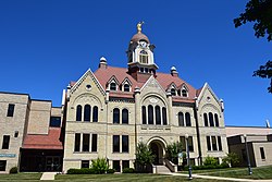
The first Christian Science church in the world was erected in 1886 in Oconto and still stands at the corner of Main Street and Chicago Street. The land was donated by Henry (1837–1904) and Victoria Sargent (1848–1930). [9] [10] [11] [12]

In 1891, the city hosted minor league baseball when the Oconto Log Drivers became charter members of the Wisconsin State League. [13] [14] [15] [16] The league began play on May 14, 1891 and the Log Drivers did not return after the first league season. [17]

In the summer of 1952, during a two-day period, an estimated 175,000,000 Leopard frogs emerged from nearby marshes and enveloped the town. The water level of Lake Michigan rose in the spring, flooding the wetlands. The Leopard frogs laid their eggs, and when the lake level receded with the heat of summer, most of the eggs would die. But in 1952, Lake Michigan remained high, and a huge number of frog eggs grew into live amphibians. [18]

Geography

ISS030-E-183973.jpg
Oconto, 1:10 AM CDT

Oconto is located at 44°53′N87°52′W / 44.883°N 87.867°W / 44.883; -87.867 (44.8877, -87.8704). [19]

According to the United States Census Bureau, the city has a total area of 7.14 square miles (18.49 km2), of which, 6.79 square miles (17.59 km2) is land and 0.35 square miles (0.91 km2) is water. [20]

Oconto is located at the mouth of the Oconto River, which feeds into Lake Michigan.

Climate

Climate data for Oconto, Wisconsin (1991–2020 normals, extremes 1893–present)
MonthJanFebMarAprMayJunJulAugSepOctNovDecYear
Record high °F (°C)58
(14)
63
(17)
83
(28)
90
(32)
98
(37)
102
(39)
105
(41)
102
(39)
98
(37)
89
(32)
75
(24)
63
(17)
105
(41)
Mean daily maximum °F (°C)26.0
(−3.3)
29.5
(−1.4)
40.4
(4.7)
53.1
(11.7)
66.2
(19.0)
76.0
(24.4)
80.5
(26.9)
79.0
(26.1)
71.7
(22.1)
58.3
(14.6)
43.9
(6.6)
31.3
(−0.4)
54.7
(12.6)
Daily mean °F (°C)17.5
(−8.1)
19.9
(−6.7)
30.5
(−0.8)
42.7
(5.9)
55.2
(12.9)
65.3
(18.5)
69.5
(20.8)
67.9
(19.9)
60.1
(15.6)
47.9
(8.8)
35.5
(1.9)
23.6
(−4.7)
44.6
(7.0)
Mean daily minimum °F (°C)8.9
(−12.8)
10.3
(−12.1)
20.6
(−6.3)
32.3
(0.2)
44.2
(6.8)
54.6
(12.6)
58.5
(14.7)
56.9
(13.8)
48.6
(9.2)
37.5
(3.1)
27.1
(−2.7)
15.8
(−9.0)
34.6
(1.4)
Record low °F (°C)−35
(−37)
−35
(−37)
−27
(−33)
5
(−15)
19
(−7)
31
(−1)
37
(3)
30
(−1)
22
(−6)
10
(−12)
−8
(−22)
−22
(−30)
−35
(−37)
Average precipitation inches (mm)1.53
(39)
1.34
(34)
2.13
(54)
3.10
(79)
3.51
(89)
4.00
(102)
4.10
(104)
3.33
(85)
3.48
(88)
3.19
(81)
2.15
(55)
1.95
(50)
33.81
(859)
Average snowfall inches (cm)10.5
(27)
11.1
(28)
7.9
(20)
4.9
(12)
0.1
(0.25)
0.0
(0.0)
0.0
(0.0)
0.0
(0.0)
0.0
(0.0)
0.2
(0.51)
2.3
(5.8)
14.5
(37)
51.5
(131)
Average precipitation days (≥ 0.01 in)7.85.66.99.610.210.210.58.68.58.67.07.8101.3
Average snowy days (≥ 0.1 in)6.75.23.31.90.10.00.00.00.00.21.75.824.9
Source: NOAA [21] [22]

Demographics

Historical population
CensusPop.Note
1860 885
1870 2,655200.0%
1880 4,17157.1%
1890 5,21925.1%
1900 4,646−11.0%
1910 5,62921.2%
1920 4,920−12.6%
1930 5,0302.2%
1940 5,3626.6%
1950 5,055−5.7%
1960 4,805−4.9%
1970 4,667−2.9%
1980 4,505−3.5%
1990 4,474−0.7%
2000 4,7085.2%
2010 4,513−4.1%
2020 4,6092.1%
U.S. Decennial Census [23]

The table with historical census data [24] indicates that the population has remained relatively flat throughout the 20th century.

2020 census

As of the census of 2020, [2] the population was 4,609. The population density was 679.3 inhabitants per square mile (262.3/km2). There were 2,175 housing units at an average density of 320.6 per square mile (123.8/km2). The racial makeup of the city was 91.8% White, 2.1% Native American, 0.5% Black or African American, 0.4% Asian, 0.7% from other races, and 4.5% from two or more races. Ethnically, the population was 3.1% Hispanic or Latino of any race.

2010 census

As of the census [25] of 2010, there were 4,513 people, 1,872 households, and 1,172 families residing in the city. The population density was 657.9 inhabitants per square mile (254.0/km2). There were 2,094 housing units at an average density of 305.2 per square mile (117.8/km2). The racial makeup of the city was 96.4% White, 0.7% African American, 1.1% Native American, 0.4% Asian, 0.4% from other races, and 1.2% from two or more races. Hispanic or Latino of any race were 2.4% of the population.

There were 1,872 households, of which 30.0% had children under the age of 18 living with them, 45.1% were married couples living together, 11.4% had a female householder with no husband present, 6.1% had a male householder with no wife present, and 37.4% were non-families. 32.2% of all households were made up of individuals, and 15.1% had someone living alone who was 65 years of age or older. The average household size was 2.35 and the average family size was 2.95.

The median age in the city was 39.6 years. 23.4% of residents were under the age of 18; 8.9% were between the ages of 18 and 24; 24.5% were from 25 to 44; 27.3% were from 45 to 64; and 15.8% were 65 years of age or older. The gender makeup of the city was 49.7% male and 50.3% female.

2000 census

As of the census [26] of 2000, there were 4,708 people, 1,870 households, and 1,221 families residing in the city. The population density was 683.7 people per square mile (263.8/km2). There were 2,040 housing units at an average density of 296.2 per square mile (114.3/km2). The racial makeup of the city was 97.79% White, 0.02% Black or African American, 0.85% Native American, 0.17% Asian, 0.06% Pacific Islander, 0.21% from other races, and 0.89% from two or more races. 0.79% of the population were Hispanic or Latino of any race.

There were 1,870 households, out of which 33.2% had children under the age of 18 living with them, 49.1% were married couples living together, 11.5% had a female householder with no husband present, and 34.7% were non-families. 29.3% of all households were made up of individuals, and 15.0% had someone living alone who was 65 years of age or older. The average household size was 2.44 and the average family size was 2.99.

In the city, the population was spread out, with 25.8% under the age of 18, 8.8% from 18 to 24, 27.8% from 25 to 44, 21.0% from 45 to 64, and 16.7% who were 65 years of age or older. The median age was 37 years. For every 100 females, there were 92.2 males. For every 100 females age 18 and over, there were 89.0 males.

The median income for a household in the city was $34,589, and the median income for a family was $43,676. Males had a median income of $27,455 versus $22,083 for females. The per capita income for the city was $20,717. About 5.2% of families and 8.8% of the population were below the poverty line, including 9.6% of those under age 18 and 10.5% of those age 65 or over.

Education

Welcome signs on U.S. Route 41 OcontoWisconsinSigns.jpg
Welcome signs on U.S. Route 41
Looking north at the eastern terminus of Wisconsin Highway 22 at U.S. Route 41 in Oconto OcontoWisconsinUS41WIS22EastTerminus.jpg
Looking north at the eastern terminus of Wisconsin Highway 22 at U.S. Route 41 in Oconto

The following schools are available in Oconto: [27]

Transportation

Major highways

Airport

J. Douglas Bake Memorial Airport (KOCQ) serves the city and surrounding communities.

Notable businesses

Notable people

Related Research Articles

<span class="mw-page-title-main">Oconto County, Wisconsin</span> County in Wisconsin, United States

Oconto County is a county in the U.S. state of Wisconsin. As of the 2020 census, the population was 38,965. Its county seat is Oconto. The county was established in 1851.

<span class="mw-page-title-main">Menominee County, Wisconsin</span> County in Wisconsin, United States

Menominee County is a county in the U.S. state of Wisconsin. As of the 2020 census, the population was 4,255, making it the least populous county in Wisconsin. Its county seat is in the community of Keshena.

<span class="mw-page-title-main">Marinette County, Wisconsin</span> County in Wisconsin, United States

Marinette County is a county in the U.S. state of Wisconsin. As of the 2020 census, the population was 41,872. Its county seat is Marinette. Marinette County is part of the Marinette, WI–MI Micropolitan Statistical Area.

<span class="mw-page-title-main">Norway, Michigan</span> City in Michigan, United States

Norway is a city in Dickinson County in the U.S. state of Michigan. The population was 2,840 at the 2020 census. It is part of the Iron Mountain, MI–WI micropolitan statistical area.

<span class="mw-page-title-main">Kewaunee, Wisconsin</span> City in Wisconsin, United States

Kewaunee is a city in Kewaunee County, Wisconsin, United States. The population was 2,837 at the 2020 census. Located on the northwestern shore of Lake Michigan, the city is the county seat of Kewaunee County. Its Menominee name is Kewāneh, an archaic name for a species of duck.

<span class="mw-page-title-main">Breed, Wisconsin</span> Town in Wisconsin, United States

Breed is a town in Oconto County, Wisconsin, United States. The population was 657 at the 2000 census.

<span class="mw-page-title-main">Pensaukee, Wisconsin</span> Town in Wisconsin, United States

Pensaukee is a town in Oconto County, Wisconsin, United States, on the coast of Green Bay. The population was 1,214 at the 2000 census.

<span class="mw-page-title-main">Stiles, Wisconsin</span> Town in Wisconsin, United States

Stiles is a town in Oconto County, Wisconsin, United States. The population was 1,465 at the 2000 census. The unincorporated communities of Stiles and Stiles Junction are located in the town. Situated within ancestral Menominee territory that was ceded to the United States in the 1836 Treaty of the Cedars, its Menominee name is Pæhkuahkiw which means "pointed hillock".

<span class="mw-page-title-main">Suring, Wisconsin</span> Village in Wisconsin, United States

Suring is a village in Oconto County, Wisconsin, United States, along the 45th parallel. The population was 544 at the 2010 census. It is part of the Green Bay Metropolitan Statistical Area.

<span class="mw-page-title-main">Underhill, Wisconsin</span> Town in Wisconsin, United States

Underhill is a town in Oconto County, Wisconsin, United States. The population was 846 at the 2000 census.

<span class="mw-page-title-main">Shiocton, Wisconsin</span> Village in Wisconsin, United States

Shiocton is a village in Outagamie County, Wisconsin, United States. The population was 921 at the 2010 census. It is wholly surrounded by the Town of Bovina.

<span class="mw-page-title-main">Clintonville, Wisconsin</span> City in Wisconsin, United States

Clintonville is a city in Waupaca County, Wisconsin, United States. The population was 4,591 at the 2020 census. The area that became Clintonville was first settled in March, 1855.

<span class="mw-page-title-main">Mishicot, Wisconsin</span> Village in Wisconsin, United States

Mishicot is a village in Manitowoc County, Wisconsin, United States. The population was 1,442 at the 2010 census. The village is adjacent to the Town of Mishicot.

<span class="mw-page-title-main">Mosinee, Wisconsin</span> City in Wisconsin, United States

Mosinee is a city in Marathon County, Wisconsin. It is part of the Wausau, Wisconsin Metropolitan Statistical Area. The population was 4,452 at the time of the 2020 census.

<span class="mw-page-title-main">Gillett, Wisconsin</span> City in Wisconsin, United States

Gillett is a city in Oconto County, Wisconsin, United States. The population was 1,386 at the 2010 census. It is part of the Green Bay Metropolitan Statistical Area. The city is adjacent to the Town of Gillett.

<span class="mw-page-title-main">Lena, Wisconsin</span> Village in Wisconsin, United States

Lena is a village in Oconto County, Wisconsin, United States. The population was 564 at the 2010 census. It is part of the Green Bay Metropolitan Statistical Area. The village is located within the Town of Lena.

<span class="mw-page-title-main">Oconto Falls, Wisconsin</span> City in Wisconsin, United States

Oconto Falls is a city in Oconto County, Wisconsin, United States. The population was 2,957 at the 2020 census. It is part of the Green Bay Metropolitan Statistical Area.

<span class="mw-page-title-main">Kaukauna, Wisconsin</span> City in Wisconsin, United States

Kaukauna is a city in Outagamie and Calumet counties, Wisconsin, United States. It is situated on the Fox River, approximately 100 miles (160 km) north of Milwaukee. The population was 17,089 at the 2020 census. It is a part of the Appleton, Wisconsin Metropolitan Statistical Area.

<span class="mw-page-title-main">Fremont, Wisconsin</span> Village in Wisconsin, United States

Fremont is a village in Waupaca County, Wisconsin, United States. It is surrounded by Town of Fremont. The population was 679 at the 2010 census. Fremont has been referred to as the "White Bass Capital of the World."

<span class="mw-page-title-main">Waupaca, Wisconsin</span> City in Wisconsin, United States

Waupaca is a city in and the county seat of Waupaca County in the U.S. state of Wisconsin. The population was 6,282 at the 2020 census.

References

  1. "2019 U.S. Gazetteer Files". United States Census Bureau. Retrieved August 7, 2020.
  2. 1 2 "2020 Decennial Census: Oconto city, Wisconsin". data.census.gov. U.S. Census Bureau. Retrieved August 6, 2022.
  3. 1 2 3 "History of Oconto". City of Oconto Wisconsin. Retrieved October 6, 2018.
  4. Hall, George E. 2009. A History of Oconto. 2nd ed., edited by Duane Ebert and Pamela Ann Loberger. Oconto, WI: Oconto County Historical Society, p. 33.
  5. "Menominee Treaties and Treaty Rights". Indian Country Wisconsin. Retrieved October 6, 2018.
  6. City-Data.com: Oconto, Wisconsin. Retrieved 2010-08-03.
  7. Chicago and North Western Railway Company (1908). A History of the Origin of the Place Names Connected with the Chicago & North Western and Chicago, St. Paul, Minneapolis & Omaha Railways. p. 109.
  8. Hoffman, Mike. "Menominee Place Names in Wisconsin". The Menominee Clans Story. Retrieved October 6, 2018.
  9. Nichols, Diane et al. West Main Street Historic District Oconto, Wisconsin (brochure). Oconto, WI: Oconto County Historical Society, no date, p. 6.
  10. Hall, George E. 2009. A History of Oconto. 2nd ed., edited by Duane Ebert and Pamela Ann Loberger. Oconto, WI: Oconto County Historical Society, p. 130.
  11. Chiat, Marilyn Joyce Segal. 1997. America's Religious Architecture: Sacred Places for Every Community. New York: John Wiley, p. 133.
  12. Cather, Willa & Georgine Milmine. 1909. The Life of Mary Baker G. Eddy and the History of Christian Science. New York: Doubleday, p. 364.
  13. "1891 Oconto Log Drivers Statistics". Baseball-Reference.com.
  14. "Page 16".
  15. "1891 Wisconsin State League". Baseball-Reference.com.
  16. "Article clipped from Atchison Daily Patriot". Atchison Daily Patriot. August 20, 1891. p. 3 via newspapers.com.
  17. "1891 Wisconsin State League (WSL) Minor League Baseball on StatsCrew.com". www.statscrew.com.
  18. "The Giant Frog Invasion Of 1952....It Happened in Oconto" . Retrieved January 23, 2019.
  19. "US Gazetteer files: 2010, 2000, and 1990". United States Census Bureau. February 12, 2011. Retrieved April 23, 2011.
  20. "2020 Gazetteer Files". census.gov. U.S. Census Bureau. Retrieved August 6, 2022.
  21. "NOWData - NOAA Online Weather Data". National Oceanic and Atmospheric Administration. Retrieved March 22, 2024.
  22. "Summary of Monthly Normals 1991-2020". National Oceanic and Atmospheric Administration. Retrieved March 22, 2024.
  23. "Census of Population and Housing". Census.gov. Retrieved June 4, 2015.
  24. "City of Oconto Comprehensive Outdoor Recreation Plan, Population Trends Table 2A and WDOA Population Projections Table 2B" (PDF). Archived from the original (PDF) on July 25, 2011. Retrieved August 3, 2010.
  25. "U.S. Census website". United States Census Bureau . Retrieved November 18, 2012.
  26. "U.S. Census website". United States Census Bureau . Retrieved January 31, 2008.
  27. City-Data.com: Schools in Oconto, Wisconsin. Retrieved 2010-08-03.