Townsend, Wisconsin

Last updated

Townsend, Wisconsin
WIMap-doton-Townsend.png
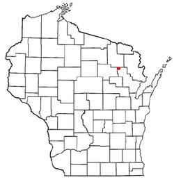
Location of Townsend, Wisconsin
Coordinates: 45°19′5″N88°36′57″W / 45.31806°N 88.61583°W / 45.31806; -88.61583
Country Flag of the United States.svg  United States
State Flag of Wisconsin.svg  Wisconsin
County Oconto
Area
  Total42.5 sq mi (110.0 km2)
  Land39.0 sq mi (101.0 km2)
  Water3.5 sq mi (9.0 km2)
Elevation
[1]
1,388 ft (423 m)
Population
 (2000)
  Total963
  Density24.7/sq mi (9.5/km2)
Time zone UTC-6 (Central (CST))
  Summer (DST) UTC-5 (CDT)
Area code(s) 715 & 534
FIPS code 55-80325 [2]
GNIS feature ID1584287 [1]
Website http://www.townsendwisconsin.org

Townsend is a town in Oconto County, Wisconsin, United States. The population was 963 at the 2000 census. The census-designated place of Townsend is located in the town.

Contents

Geography

According to the United States Census Bureau, the town has a total area of 42.5 square miles (109.9 km2), of which, 39.0 square miles (101.0 km2) of it is land and 3.5 square miles (9.0 km2) of it (8.15%) is surface water.

Demographics

As of the census [2] of 2000, there were 963 people, 436 households, and 313 families residing in the town. The population density was 24.7 people per square mile (9.5/km2). There were 1,450 housing units at an average density of 37.2 per square mile (14.4/km2). The racial makeup of the town was 97.51% White, 0.10% African American, 0.62% Native American, 0.10% Pacific Islander, 0.31% from other races, and 1.35% from two or more races. Hispanic or Latino of any race were 0.73% of the population.

There were 436 households, out of which 17.2% had children under the age of 18 living with them, 63.5% were married couples living together, 5.0% had a female householder with no husband present, and 28.0% were non-families. 24.1% of all households were made up of individuals, and 11.9% had someone living alone who was 65 years of age or older. The average household size was 2.21 and the average family size was 2.55.

In the town, the population was spread out, with 16.9% under the age of 18, 4.0% from 18 to 24, 17.9% from 25 to 44, 34.8% from 45 to 64, and 26.4% who were 65 years of age or older. The median age was 53 years. For every 100 females, there were 104.0 males. For every 100 females age 18 and over, there were 100.0 males.

The median income for a household in the town was $28,456, and the median income for a family was $36,875. Males had a median income of $32,000 versus $19,250 for females. The per capita income for the town was $16,680. About 3.9% of families and 6.8% of the population were below the poverty line, including 11.2% of those under age 18 and 2.0% of those age 65 or over.

Notable people

Related Research Articles

<span class="mw-page-title-main">Avra Valley, Arizona</span> CDP in Pima County, Arizona

Avra Valley is a census-designated place (CDP) in Pima County, Arizona, United States. The population was 6,050 at the 2010 census, up from 5,038 in 2000.

<span class="mw-page-title-main">Symerton, Illinois</span> Village in Illinois, United States

Symerton is a village in Will County, Illinois, United States. The population was 128 at the 2020 census. By population, it is the smallest village in Will County.

<span class="mw-page-title-main">Spiceland, Indiana</span> Town in Indiana, United States

Spiceland is a town in Spiceland Township, Henry County, Indiana, United States. The population was 890 at the 2010 census.

<span class="mw-page-title-main">Eagle Lake, Maine</span> Town in the state of Maine, United States

Eagle Lake is a town in Aroostook County, Maine, United States. The population was 772 at the 2020 census. The town was named by a body of troops heading from Bangor to the Aroostook War for the many eagles that they saw around the lake. A total of 49.0% of the population speaks French, reflecting a trend in Northeastern Maine.

Aurora is a town in Hancock County, Maine, United States. The town was named for the goddess of dawn. The population was 93 at the 2020 census.

<span class="mw-page-title-main">Hartford, Maine</span> Town in the state of Maine, United States

Hartford is a town in Oxford County, Maine, United States. Hartford is included in the Lewiston-Auburn, Maine metropolitan New England City and Town Area. The population was 1,203 at the 2020 census.

<span class="mw-page-title-main">Lake Shore, Minnesota</span> City in Minnesota, United States

Lake Shore is a city in Cass County, Minnesota, United States. The population was 1,056 at the 2020 census. It is part of the Brainerd Micropolitan Statistical Area.

Peace Township is a township in Kanabec County, Minnesota, United States. The population was 963 at the 2000 census.

<span class="mw-page-title-main">Lena, Mississippi</span> Town in Mississippi, United States

Lena is a town in Leake County, Mississippi, United States. The population was 148 at the 2010 census. The center of population of Mississippi is located in Lena.

Tribes Hill is a census-designated place (CDP) located in the Towns of Mohawk (80%) and Amsterdam (20%) in Montgomery County, New York, United States. The population was 1,003 at the 2010 census. One theory is the name is based on this location having been a gathering spot for the Mohawk nation, the dominant Iroquois tribe in the area during colonial times. Tribes Hill spans the border of the Town of Mohawk and Town of Amsterdam, approximately five miles west of the City of Amsterdam on Route 5.

<span class="mw-page-title-main">Aberdeen, Ohio</span> Village in Ohio, United States

Aberdeen is a village in Huntington Township, Brown County, Ohio, United States, along the Ohio River 50 miles (80 km) southeast of Cincinnati. The population was 1,515 at the 2020 census.

<span class="mw-page-title-main">Hilda, South Carolina</span> Town in South Carolina, United States

Hilda is a town in Barnwell County, South Carolina, United States. The population was 447 at the 2010 census..

<span class="mw-page-title-main">Wall, South Dakota</span> Town in South Dakota, United States

Wall is a town in Pennington County, South Dakota, United States. The population was 699 at the 2020 census.

<span class="mw-page-title-main">LeRoy, Wisconsin</span> Town in Wisconsin, United States

LeRoy is a town in Dodge County, Wisconsin, United States. The population was 1,116 at the 2000 census. The unincorporated communities of Farmersville and LeRoy are located in the town.

<span class="mw-page-title-main">Ross, Wisconsin</span> Town in Wisconsin, United States

Ross is a town in Forest County, Wisconsin, United States. The population was 132 at the 2020 census. The census-designated place of Newald is located in the town.

<span class="mw-page-title-main">Wabeno, Wisconsin</span> Town in Wisconsin, United States

Wabeno is a town in Forest County, Wisconsin, United States. The population was 1,166 at the 2010 census. The census-designated place of Wabeno and the unincorporated communities of Carter, Padus, and Soperton are located in the town. Wabeno is situated within Wisconsin's 7th congressional district.

<span class="mw-page-title-main">Lake Tomahawk, Wisconsin</span> Town in Wisconsin, United States

Lake Tomahawk is a town in Oneida County, Wisconsin, United States named for the adjacent freshwater lake of the same name. The population was 1,160 at the 2000 census. The census-designated place of Lake Tomahawk and the unincorporated community of Sunflower are located in the town.

<span class="mw-page-title-main">Brillion, Wisconsin</span> City in Wisconsin, United States

Brillion is a city in Calumet County in the U.S. state of Wisconsin. The population was 3,538 as of 2024. The city is located within the Town of Brillion, though it is politically independent.

Somerset is a town in St. Croix County, Wisconsin, United States. The population was 4,036 at the 2010 census. The Village of Somerset is adjacent to the town.

<span class="mw-page-title-main">Darien, Wisconsin</span> Village in Wisconsin, United States

Darien is a village in Walworth County, Wisconsin, United States. The population was 1,573 at the 2020 census. The village is located within the Town of Darien.

References

  1. 1 2 "US Board on Geographic Names". United States Geological Survey. October 25, 2007. Retrieved January 31, 2008.
  2. 1 2 "U.S. Census website". United States Census Bureau . Retrieved January 31, 2008.
  3. Baseball in Wartine-Russ Bauers

45°19′41″N88°35′22″W / 45.32806°N 88.58944°W / 45.32806; -88.58944