Wautoma, Wisconsin | |
|---|---|
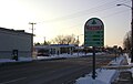
 Looking west at downtown Wautoma, Wisconsin | |
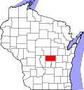
 Location of Wautoma in Waushara County, Wisconsin. | |
 Wautoma  Wautoma | |
| Coordinates: 44°4′17″N89°17′23″W / 44.07139°N 89.28972°W | |
| Country | |
| State | |
| County | Waushara |
| Area | |
• Total | 2.83 sq mi (7.34 km2) |
| • Land | 2.79 sq mi (7.23 km2) |
| • Water | 0.042 sq mi (0.11 km2) |
| Elevation | 863 ft (263 m) |
| Population | |
• Total | 2,209 |
| • Density | 791/sq mi (306/km2) |
| Time zone | UTC-6 (Central (CST)) |
| • Summer (DST) | UTC-5 (CDT) |
| ZIP Code | 54982 |
| Area code | 920 |
| FIPS code | 55-84625 |
| GNIS feature ID | 1576330 [2] |
| Website | http://www.cityofwautoma.com/ |
Wautoma is a city in and the county seat of Waushara County, Wisconsin, United States. The population was 2,209 at the 2020 census.
Contents
- Geography
- Demographics
- 2010 census
- 2000 census
- Transportation
- Media
- News media
- Radio
- High school sports
- Notable people
- Images
- See also
- References
- External links
The city consists of three noncontiguous areas: one is entirely surrounded by the Town of Wautoma, the second is entirely surrounded by the Town of Dakota, and the third and largest straddles the boundary between the two towns.
Wautoma calls itself the "Christmas tree capital of the world". [4] [5] [6] [7] The Kirk Company of Tacoma, Washington, operated the "Wautoma plantation" of more than 10,000 acres (4,000 ha) of Christmas trees, beginning in 1953. [8]
On August 29, 1992, the town was struck by a half-mile wide F-3 tornado, killing 2 people, injuring 30 others, and causing over $5 million in damage. [9]