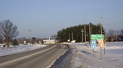
Wild Rose, Wisconsin

Last updated

Wild Rose, Wisconsin
Wild Rose sign.jpg
Waushara County Wisconsin Incorporated and Unincorporated areas Wild Rose Highlighted.svg
Location of Wild Rose in Waushara County, Wisconsin.
Coordinates: 44°10′37″N89°14′46″W / 44.17694°N 89.24611°W / 44.17694; -89.24611
Country Flag of the United States.svg  United States
State Flag of Wisconsin.svg  Wisconsin
County Waushara
Area
[1]
  Total1.48 sq mi (3.83 km2)
  Land1.45 sq mi (3.77 km2)
  Water0.02 sq mi (0.06 km2)
Elevation
[2]
950 ft (290 m)
Population
 (2010) [3]
  Total725
  Estimate 
(2019) [4]
684
  Density470.43/sq mi (181.67/km2)
Time zone UTC-6 (Central (CST))
  Summer (DST) UTC-5 (CDT)
Area code 920
FIPS code 55-87075 [5]
GNIS feature ID1576731 [2]
Website www.villageofwildrose.com

Wild Rose is a village in Waushara County, Wisconsin, United States. The population was 725 at the 2010 census.

Contents

History

A post office called Wild Rose has been in operation since 1873. [6] The village was named from wild rose bushes near the original town site, although many early settlers arrived from Rose, New York in the mid 1850's and the town may be named Wild Rose in reference to Rose, NY. [7]

The Wild Rose Historical Society maintains Pioneer Museum on Main Street in Wild Rose. [8]

Geography

Wild Rose is located at 44°10′37″N89°14′46″W / 44.17694°N 89.24611°W / 44.17694; -89.24611 (44.177054, -89.246242). [9]

According to the United States Census Bureau, the village has a total area of 1.55 square miles (4.01 km2), of which, 1.53 square miles (3.96 km2) of it is land and 0.02 square miles (0.05 km2) is water. [10]

Demographics

Historical population
CensusPop.Note
1880 25
1910 551
1920 5764.5%
1930 512−11.1%
1940 5599.2%
1950 5824.1%
1960 5942.1%
1970 585−1.5%
1980 74126.7%
1990 676−8.8%
2000 76513.2%
2010 725−5.2%
2019 (est.)684 [4] −5.7%
U.S. Decennial Census [11]

2010 census

As of the census [3] of 2010, there were 725 people, 316 households, and 174 families living in the village. The population density was 473.9 inhabitants per square mile (183.0/km2). There were 377 housing units at an average density of 246.4 per square mile (95.1/km2). The racial makeup of the village was 95.9% White, 0.7% Native American, 0.6% Asian, 1.8% from other races, and 1.1% from two or more races. Hispanic or Latino of any race were 4.8% of the population.

There were 316 households, of which 24.1% had children under the age of 18 living with them, 40.5% were married couples living together, 11.4% had a female householder with no husband present, 3.2% had a male householder with no wife present, and 44.9% were non-families. 42.4% of all households were made up of individuals, and 24.6% had someone living alone who was 65 years of age or older. The average household size was 2.05 and the average family size was 2.78.

The median age in the village was 49.4 years. 19.2% of residents were under the age of 18; 3.8% were between the ages of 18 and 24; 19.4% were from 25 to 44; 25.1% were from 45 to 64; and 32.4% were 65 years of age or older. The gender makeup of the village was 45.0% male and 55.0% female.

2000 census

As of the census [5] of 2000, there were 765 people, 312 households, and 186 families living in the village. The population density was 580.1 people per square mile (223.8/km2). There were 339 housing units at an average density of 257.0 per square mile (99.2/km2). The racial makeup of the village was 97.25% White, 0.78% African American, 0.13% Native American, 0.26% Asian, 0.92% from other races, and 0.65% from two or more races. Hispanic or Latino of any race were 2.22% of the population.

There were 312 households, out of which 29.5% had children under the age of 18 living with them, 43.9% were married couples living together, 11.2% had a female householder with no husband present, and 40.1% were non-families. 36.9% of all households were made up of individuals, and 19.6% had someone living alone who was 65 years of age or older. The average household size was 2.26 and the average family size was 2.97.

In the village, the population was spread out, with 23.5% under the age of 18, 5.8% from 18 to 24, 22.7% from 25 to 44, 21.3% from 45 to 64, and 26.7% who were 65 years of age or older. The median age was 43 years. For every 100 females, there were 83.5 males. For every 100 females age 18 and over, there were 76.7 males.

The median income for a household in the village was $30,655, and the median income for a family was $37,361. Males had a median income of $32,188 versus $20,438 for females. The per capita income for the village was $18,887. About 4.2% of families and 6.6% of the population were below the poverty line, including 4.1% of those under age 18 and 12.8% of those age 65 or over.

Notable people

Images

Related Research Articles

<span class="mw-page-title-main">Loughman, Florida</span> Census-designated place in Florida, United States

Loughman (LOFF-mǝn) is a census-designated place (CDP) in the northeast corner of Polk County, Florida, United States, near the Osceola county line. The population was 1,385 at the 2000 census. It is part of the Lakeland–Winter Haven Metropolitan Statistical Area. This area has grown rapidly since 2000 due, in large part, to its proximity to Walt Disney World and the Orlando, Florida area.

<span class="mw-page-title-main">Wilder, Idaho</span> City in Idaho, United States

Wilder is a city in Canyon County, Idaho, United States. The population was 1,533 at the 2010 census.

<span class="mw-page-title-main">Bradford, Illinois</span> Village in Illinois, United States

Bradford is a village in Stark County, Illinois, United States. The population was 768 at the 2010 census. Bradford is part of the Peoria, Illinois Metropolitan Statistical Area.

<span class="mw-page-title-main">Chance, Maryland</span> CDP in Maryland, United States

Chance is a census-designated place (CDP) in Somerset County, Maryland, United States. The population was 377 at the 2000 census. It is included in the Salisbury, Maryland-Delaware Metropolitan Statistical Area.

<span class="mw-page-title-main">Ellsworth, Michigan</span> Village in Michigan, United States

Ellsworth is a village in Antrim County in the U.S. state of Michigan. The population was 349 at the 2010 census. The village is located within Banks Township.

<span class="mw-page-title-main">Mansfield, Missouri</span> Town in Wright County

Mansfield is a city in Wright County, Missouri, United States. The population was 1,296 at the 2010 census.

<span class="mw-page-title-main">Roseland, Nebraska</span> Village in Nebraska, United States

Roseland is a village in Adams County, Nebraska, United States. The population was 260 at the 2020 census. It is part of the Hastings, Nebraska Micropolitan Statistical Area.

<span class="mw-page-title-main">Arcadia, Nebraska</span> Village in Valley County, Nebraska, United States

Arcadia is a village in Valley County, Nebraska, United States. The population was 311 at the 2010 census.

<span class="mw-page-title-main">Milan, New Mexico</span> Village in New Mexico, United States

Milan is a village in Cibola County, New Mexico, United States. The population was 3,245 at the 2010 census.

<span class="mw-page-title-main">Covington, Texas</span> City in Texas, United States

Covington is a city in Hill County in central Texas, United States. Located at the intersection of FM 67 and State Highway 171, 14 miles (23 km) north of Hillsboro, it is near the northern boundary of Hill County. It was founded by Colonel James Jackson Gathings, formerly of North Carolina and Mississippi, in the spring of 1852, and is named for his wife's family. Gathings secured about 10,000 acres (40 km2) of land in what is now Hill County, 100 of which were set aside for the new town of Covington. The population of Covington, 158 years later, was 269 at the 2010 census.

<span class="mw-page-title-main">Manchester Center, Vermont</span> Census-designated place in Vermont, United States

Manchester Center is a census-designated place (CDP) in the town of Manchester in Bennington County, Vermont, United States. As of the 2010 census, the CDP had a population of 2,120, out of 4,391 people in the entire town of Manchester.

<span class="mw-page-title-main">John Sam Lake, Washington</span> Former CDP in Washington, United States

John Sam Lake is a former census-designated place (CDP) in Snohomish County, Washington, United States. The population was 753 at the 2000 census. The CDP was discontinued at the 2010 census.

<span class="mw-page-title-main">Montrose, West Virginia</span> Town in West Virginia, United States

Montrose is a town in Randolph County, West Virginia, United States. The population was 141 at the 2020 census.

<span class="mw-page-title-main">Bay City, Wisconsin</span> Village in Wisconsin, United States

Bay City is a village on the Mississippi River in Pierce County, Wisconsin, United States. The population was 500 at the 2010 census.

<span class="mw-page-title-main">Nelsonville, Wisconsin</span> Village in Wisconsin, United States

Nelsonville is a village in Portage County, Wisconsin, United States. The population was 155 at the 2010 census.

<span class="mw-page-title-main">Mount Morris, Wisconsin</span> Town in Wisconsin, United States

Mount Morris is a town in central Waushara County, Wisconsin, United States. The population was 1,092 at the 2000 census. The unincorporated community of Mount Morris is located in the town.

<span class="mw-page-title-main">Clayton, Kansas</span> City in Decatur and Norton Counties of Kansas

Clayton is a city in Decatur and Norton counties in the U.S. state of Kansas. As of the 2020 census, the population of the city was 44.

<span class="mw-page-title-main">Pepin, Wisconsin</span> Village in Wisconsin, United States

Pepin is a village in Pepin County, Wisconsin, United States. The population was 837 at the 2010 census. The village is located within the Town of Pepin.

Plainfield is a town in Waushara County, Wisconsin, United States. The population was 533 at the 2000 census. The village of Plainfield is surrounded by the town. The ghost town of West Plainfield is located in the town.

<span class="mw-page-title-main">Wautoma (town), Wisconsin</span> Town in Wisconsin, United States

Wautoma is a town in Waushara County, Wisconsin, United States. The population was 1,312 at the 2000 census.

References

  1. "2019 U.S. Gazetteer Files". United States Census Bureau. Retrieved August 7, 2020.
  2. 1 2 U.S. Geological Survey Geographic Names Information System: Wild Rose, Wisconsin
  3. 1 2 "U.S. Census website". United States Census Bureau . Retrieved November 18, 2012.
  4. 1 2 "Population and Housing Unit Estimates". United States Census Bureau. May 24, 2020. Retrieved May 27, 2020.
  5. 1 2 "U.S. Census website". United States Census Bureau . Retrieved January 31, 2008.
  6. "Waushara County". Jim Forte Postal History. Retrieved April 1, 2015.
  7. Chicago and North Western Railway Company (1908). A History of the Origin of the Place Names Connected with the Chicago & North Western and Chicago, St. Paul, Minneapolis & Omaha Railways. p. 139.
  8. "History". Village of Wild Rose. Retrieved February 4, 2018.
  9. "US Gazetteer files: 2010, 2000, and 1990". United States Census Bureau. February 12, 2011. Retrieved April 23, 2011.
  10. "US Gazetteer files 2010". United States Census Bureau . Retrieved November 18, 2012.
  11. "Census of Population and Housing". Census.gov. Retrieved June 4, 2015.
  12. 'Wisconsin Blue Book 1948,' Biographical Sketch of Boyd A. Clark, p. 50.