Hancock, Wisconsin

Last updated

Hancock, Wisconsin
Waushara County Wisconsin Incorporated and Unincorporated areas Hancock Highlighted.svg
Location of Hancock in Waushara County, Wisconsin.
Coordinates: 44°6′55″N89°32′7″W / 44.11528°N 89.53528°W / 44.11528; -89.53528
Country Flag of the United States.svg  United States
State Flag of Wisconsin.svg  Wisconsin
County Waushara
Area
[1]
  Total1.05 sq mi (2.71 km2)
  Land1.05 sq mi (2.71 km2)
  Water0.00 sq mi (0.00 km2)
Elevation
[2]
1,086 ft (331 m)
Population
 (2010) [3]
  Total417
  Estimate 
(2019) [4]
405
  Density386.82/sq mi (149.35/km2)
Time zone UTC-6 (Central (CST))
  Summer (DST) UTC-5 (CDT)
Area code(s) 715 & 534
FIPS code 55-32450 [5]
GNIS feature ID1566028 [2]

Hancock is a village in Waushara County, Wisconsin, United States. The population was 417 at the 2010 census. The village is located within the Town of Hancock.

Contents

Geography

Hancock is located at 44°7′55″N89°30′55″W / 44.13194°N 89.51528°W / 44.13194; -89.51528 (44.132203, -89.515344). [6]

According to the United States Census Bureau, the village has a total area of 1.12 square miles (2.90 km2), of which 1.07 square miles (2.77 km2) of it is land and 0.05 square miles (0.13 km2) is water. [7]

Climate

Climate data for Hancock Experiment Farm (1991–2020 normals, extremes 1902–present)
MonthJanFebMarAprMayJunJulAugSepOctNovDecYear
Record high °F (°C)59
(15)
71
(22)
84
(29)
90
(32)
105
(41)
106
(41)
112
(44)
105
(41)
100
(38)
91
(33)
78
(26)
62
(17)
112
(44)
Mean daily maximum °F (°C)24.9
(−3.9)
29.6
(−1.3)
41.3
(5.2)
55.1
(12.8)
68.1
(20.1)
77.4
(25.2)
81.5
(27.5)
79.3
(26.3)
71.6
(22.0)
58.1
(14.5)
42.6
(5.9)
29.9
(−1.2)
54.9
(12.7)
Daily mean °F (°C)15.9
(−8.9)
19.6
(−6.9)
31.3
(−0.4)
44.0
(6.7)
56.6
(13.7)
66.3
(19.1)
70.1
(21.2)
68.3
(20.2)
60.4
(15.8)
47.8
(8.8)
34.1
(1.2)
21.8
(−5.7)
44.7
(7.1)
Mean daily minimum °F (°C)6.9
(−13.9)
9.7
(−12.4)
21.2
(−6.0)
32.9
(0.5)
45.2
(7.3)
55.2
(12.9)
58.8
(14.9)
57.3
(14.1)
49.3
(9.6)
37.4
(3.0)
25.6
(−3.6)
13.8
(−10.1)
34.4
(1.3)
Record low °F (°C)−43
(−42)
−40
(−40)
−39
(−39)
−3
(−19)
18
(−8)
29
(−2)
37
(3)
33
(1)
16
(−9)
0
(−18)
−19
(−28)
−32
(−36)
−43
(−42)
Average precipitation inches (mm)1.14
(29)
0.97
(25)
1.86
(47)
3.57
(91)
4.19
(106)
4.95
(126)
4.15
(105)
4.02
(102)
3.31
(84)
2.71
(69)
1.98
(50)
1.42
(36)
34.27
(870)
Average snowfall inches (cm)12.8
(33)
8.2
(21)
8.3
(21)
2.7
(6.9)
0.0
(0.0)
0.0
(0.0)
0.0
(0.0)
0.0
(0.0)
0.0
(0.0)
0.3
(0.76)
3.3
(8.4)
7.5
(19)
43.1
(109)
Average precipitation days (≥ 0.01 in)8.57.58.110.812.311.810.39.49.810.07.88.4114.7
Average snowy days (≥ 0.1 in)6.55.63.61.20.00.00.00.00.00.22.16.725.9
Source: NOAA [8] [9]

Demographics

Historical population
CensusPop.Note
1910 510
1920 443−13.1%
1930 420−5.2%
1940 48114.5%
1950 449−6.7%
1960 367−18.3%
1970 40410.1%
1980 4193.7%
1990 382−8.8%
2000 46321.2%
2010 417−9.9%
2019 (est.)405 [4] −2.9%
U.S. Decennial Census [10]

2010 census

As of the census [3] of 2010, there were 417 people, 186 households, and 107 families living in the village. The population density was 389.7 inhabitants per square mile (150.5/km2). There were 251 housing units at an average density of 234.6 per square mile (90.6/km2). The racial makeup of the village was 94.2% White, 0.5% African American, 0.2% Asian, 4.1% from other races, and 1.0% from two or more races. Hispanic or Latino of any race were 11.0% of the population.

There were 186 households, of which 26.3% had children under the age of 18 living with them, 43.0% were married couples living together, 10.8% had a female householder with no husband present, 3.8% had a male householder with no wife present, and 42.5% were non-families. 33.9% of all households were made up of individuals, and 17.3% had someone living alone who was 65 years of age or older. The average household size was 2.24 and the average family size was 2.88.

The median age in the village was 45.2 years. 20.6% of residents were under the age of 18; 8% were between the ages of 18 and 24; 21.1% were from 25 to 44; 30% were from 45 to 64; and 20.4% were 65 years of age or older. The gender makeup of the village was 48.9% male and 51.1% female.

2000 census

As of the census [5] of 2000, there were 463 people, 193 households, and 121 families living in the village. The population density was 423.3 people per square mile (164.0/km2). There were 254 housing units at an average density of 232.2 per square mile (90.0/km2). The racial makeup of the village was 92.22% White, 1.08% Native American, 0.22% Asian, 4.32% from other races, and 2.16% from two or more races. 8.64% of the population were Hispanic or Latino of any race.

There were 193 households, out of which 30.6% had children under the age of 18 living with them, 49.7% were married couples living together, 8.8% had a female householder with no husband present, and 36.8% were non-families. 30.1% of all households were made up of individuals, and 18.7% had someone living alone who was 65 years of age or older. The average household size was 2.40 and the average family size was 3.01.

In the village, the population was spread out, with 26.8% under the age of 18, 4.3% from 18 to 24, 24.2% from 25 to 44, 24.6% from 45 to 64, and 20.1% who were 65 years of age or older. The median age was 41 years. For every 100 females, there were 87.4 males. For every 100 females age 18 and over, there were 96.0 males.

The median income for a household in the village was $35,341, and the median income for a family was $36,250. Males had a median income of $31,250 versus $21,500 for females. The per capita income for the village was $14,889. About 5.7% of families and 9.5% of the population were below the poverty line, including 9.4% of those under age 18 and 15.5% of those age 65 or over.

Notable people

Related Research Articles

<span class="mw-page-title-main">Rodney Village, Delaware</span> CDP in Delaware, United States

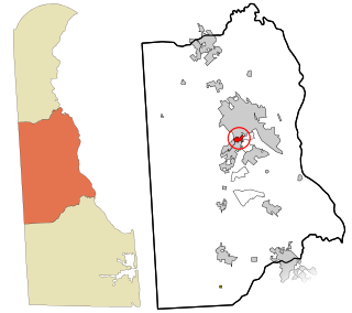
Rodney Village is a census-designated place (CDP) in Kent County, Delaware, United States. It is part of the Dover, Delaware Metropolitan Statistical Area. The population was 1,487 at the 2010 census.

<span class="mw-page-title-main">Ferris, Illinois</span> Village in Illinois, United States

Ferris is a village in Hancock County, Illinois, United States. The population was 156 at the 2010 census.

<span class="mw-page-title-main">West Point, Illinois</span> Village in Illinois, United States

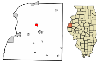
West Point is a village in Hancock County, Illinois, United States. The population was 178 at the 2010 census.

<span class="mw-page-title-main">Wilkinson, Indiana</span> Town in Indiana, United States

Wilkinson is a town in Brown Township, Hancock County, Indiana, United States. The population was 449 at the 2010 census.

<span class="mw-page-title-main">Hancock, Iowa</span> City in Iowa, United States

Hancock is a city in Pottawattamie County, Iowa, United States, along the West Nishnabotna River. The population was 200 at the time of the 2020 census.

<span class="mw-page-title-main">Franklin, Maine</span> Town in the state of Maine, United States

Franklin is a town in Hancock County, Maine, United States. The population was 1,567 at the 2020 census. The town's namesake is Benjamin Franklin.

Osborn is a town in Hancock County, Maine, United States. The population was 65 at the 2020 census.

<span class="mw-page-title-main">Fruitport, Michigan</span> Village in Michigan, United States

Fruitport is a village in Muskegon County in the U.S. state of Michigan. The population was 1,103 at the 2020 census. The community is located within Fruitport Charter Township.

<span class="mw-page-title-main">Arcadia, Ohio</span> Village in Ohio, United States

Arcadia is a village in Hancock County, Ohio, United States. The population was 564 at the 2020 census.

<span class="mw-page-title-main">Arlington, Ohio</span> Village in Ohio, United States

Arlington is a village in Hancock County, Ohio, United States. The population was 1,492 at the 2020 census.

<span class="mw-page-title-main">Benton Ridge, Ohio</span> Village in Ohio, United States

Benton Ridge is a village in Hancock County, Ohio, United States. The population was 272 at the 2020 census. It is within the boundaries of the Liberty-Benton Local School district.

<span class="mw-page-title-main">Jenera, Ohio</span> Village in Ohio, United States

Jenera is a village in Hancock County, Ohio, United States. The population was 257 at the 2020 census. It is surrounded by Van Buren Township and is part of the Cory-Rawson Local School District.

<span class="mw-page-title-main">Mount Blanchard, Ohio</span> Village in Ohio, United States

Mount Blanchard is a village in Hancock County, Ohio, United States. The population was 471 at the 2020 census.

<span class="mw-page-title-main">Mount Cory, Ohio</span> Village in Ohio, United States

Mount Cory is a village in Hancock County, Ohio, United States. The population was 225 at the 2020 census.

<span class="mw-page-title-main">Rawson, Ohio</span> Village in Ohio, United States

Rawson is a village in Hancock County, Ohio, United States. The population was 567 at the 2020 census.

<span class="mw-page-title-main">Vanlue, Ohio</span> Village in Ohio, United States

Vanlue is a village in Hancock County, Ohio, United States. The population was 341 at the 2020 census.

<span class="mw-page-title-main">Neosho, Wisconsin</span> Village in Wisconsin, United States

Neosho is a village in Dodge County, Wisconsin, United States. The population was 574 at the 2010 census.

<span class="mw-page-title-main">Hancock (village), New York</span> Village in New York, United States

Hancock is a village in Delaware County, New York, United States. The population was 908 at the 2020 census. The village is in the west part of the town of Hancock at the junction of NY Routes 17 and 97.

Platteville is a town in Grant County, Wisconsin, United States. The population was 1,513 at the 2020 census. The city of Platteville is within the town, but is politically independent.

Hancock founded in 1850 is a town in Waushara County, Wisconsin, United States. The population was 531 at the 2000 census. The Village of Hancock is located within the town.

References

  1. "2019 U.S. Gazetteer Files". United States Census Bureau. Retrieved August 7, 2020.
  2. 1 2 U.S. Geological Survey Geographic Names Information System: Hancock, Wisconsin
  3. 1 2 "U.S. Census website". United States Census Bureau . Retrieved November 18, 2012.
  4. 1 2 "Population and Housing Unit Estimates". United States Census Bureau. May 24, 2020. Retrieved May 27, 2020.
  5. 1 2 "U.S. Census website". United States Census Bureau . Retrieved January 31, 2008.
  6. "US Gazetteer files: 2010, 2000, and 1990". United States Census Bureau. February 12, 2011. Retrieved April 23, 2011.
  7. "US Gazetteer files 2010". United States Census Bureau . Retrieved November 18, 2012.
  8. "NOWData - NOAA Online Weather Data". National Oceanic and Atmospheric Administration. Retrieved March 22, 2024.
  9. "Summary of Monthly Normals 1991-2020". National Oceanic and Atmospheric Administration. Retrieved March 22, 2024.
  10. "Census of Population and Housing". Census.gov. Retrieved June 4, 2015.
  11. Finding aid, M. Eleanor Fitzgerald Papers, 1915-1974, University of Wisconsin Milwaukee, UWM Libraries.