
Long Island is a densely populated island in the southeastern region of the U.S. state of New York, part of the New York metropolitan area. With over 8 million people, Long Island is the most populous island in the United States and the 18th-most populous in the world. The island begins at New York Harbor approximately 0.35 miles (0.56 km) east of Manhattan Island and extends eastward about 118 miles (190 km) into the Atlantic Ocean, with a maximum north-to-south width of 23 miles (37 km) between Long Island Sound and the Atlantic coast. With a land area of 1,401 square miles (3,630 km2), Long Island is the 11th-largest island in the United States, the largest island in the contiguous United States, and the 149th-largest island in the world.

Maryland is a state in the Mid-Atlantic region of the United States. It borders Virginia, West Virginia, and the District of Columbia to its south and west; Pennsylvania to its north; and Delaware and the Atlantic Ocean to its east. With a total land area of 12,407 square miles (32,130 km2), Maryland is the 8th smallest state by land area, but with a population of over 6,177,200, it ranks as the 18th most populous state and the 5th most densely populated. Baltimore is the largest city in the state, and the capital is Annapolis. Among its occasional nicknames are Old Line State, the Free State, and the Chesapeake Bay State. It is named after Henrietta Maria, the French-born queen of England, Scotland, and Ireland, who was known then in England as Mary.

Nevada is a state in the Western region of the United States. It is bordered by Oregon to the northwest, Idaho to the northeast, California to the west, Arizona to the southeast, and Utah to the east. Nevada is the 7th-most extensive, the 32nd-most populous, and the 9th-least densely populated of the U.S. states. Nearly three-quarters of Nevada's people live in Clark County, which contains the Las Vegas–Paradise metropolitan area, including three of the state's four largest incorporated cities. Nevada's capital is Carson City. Las Vegas is the largest city in the state.

New Jersey is a state situated within both the Mid-Atlantic and Northeastern regions of the United States. It is the most densely populated U.S. state, and is situated at the center of the Northeast megalopolis, the most populous American urban agglomeration. New Jersey is bordered on its north and east by the state of New York; on its east, southeast, and south by the Atlantic Ocean; on its west by the Delaware River and Pennsylvania; and on its southwest by Delaware Bay and the state of Delaware. At 7,354 square miles (19,050 km2), New Jersey is the fifth-smallest state in land area, but with close to 9.3 million residents as of the 2020 United States census, its highest decennial count ever, ranks 11th in population. The state capital is Trenton, and the most populous city is Newark. New Jersey is the only U.S. state in which every county is deemed urban by the U.S. Census Bureau, with 13 counties included in the New York metropolitan area, seven counties in the Philadelphia metropolitan area, and with Warren County constituting part of the rapidly industrializing Lehigh Valley metropolitan area.

Orange County, often known by its initials O.C., is located in the Los Angeles metropolitan area in Southern California. As of the 2020 census, the population was 3,186,989, making it the third-most-populous county in California, the sixth-most-populous in the United States, and more populous than 19 American states and Washington, D.C. Although largely suburban, it is the second-most-densely-populated county in the state behind San Francisco County. The county's three most-populous cities are Anaheim, Santa Ana, and Irvine, each of which has a population exceeding 300,000. Santa Ana is also the county seat. Six cities in Orange County are on the Pacific coast: Seal Beach, Huntington Beach, Newport Beach, Laguna Beach, Dana Point, and San Clemente.

Lancashire is a ceremonial county in North West England. The administrative centre is Preston, while Lancaster is the county town. The borders of the ceremonial county were created in 1974 by the Local Government Act 1972 and enclose a population of 1,449,300 and an area of 1,189 square miles (3,080 km2). However, the modern county is a smaller portion of the extent of the historic county palatine, which includes the cities of Manchester, Salford and Liverpool as well as the Furness and Cartmel peninsulas in the Lake District, and has an area of 1,909 square miles (4,940 km2). Many of these places still identify strongly with the county, particularly in areas of Greater Manchester where Lancashire is still used as part of the postal address. The population of Lancashire in the 1971 census was 5,118,405, making it the most heavily populated county in the United Kingdom at the time.

Southern California is a geographic and cultural region that generally comprises the southern portion of the U.S. state of California. It includes the Los Angeles metropolitan area, the second most populous urban agglomeration in the United States. The region generally contains ten of California's 58 counties: Imperial, Kern, Los Angeles, Orange, Riverside, San Bernardino, San Diego, Santa Barbara, San Luis Obispo and Ventura counties.
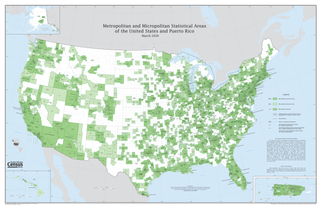
In the United States, a metropolitan statistical area (MSA) is a geographical region with a relatively high population density at its core and close economic ties throughout the area. Such regions are neither legally incorporated as a city or town would be, nor are they legal administrative divisions like counties or separate entities such as states; because of this, the precise definition of any given metropolitan area can vary with the source. The statistical criteria for a standard metropolitan area were defined in 1949 and redefined as metropolitan statistical area in 1983.

Los Angeles County, officially the County of Los Angeles, and sometimes abbreviated as L.A. County, is the most populous county in the United States, with 9,861,224 residents estimated in 2022. Its population is greater than that of 40 individual U.S. states. Comprising 88 incorporated cities and many unincorporated areas within a total area of 4,083 square miles (10,570 km2), it is home to more than a quarter of Californians and is one of the most ethnically diverse U.S. counties. The county's seat, Los Angeles, is the second most populous city in the United States, with about 3.9 million residents.

In the United States, a county or county equivalent is an administrative or political subdivision of a state that consists of a geographic region with specific boundaries and usually some level of governmental authority. The term "county" is used in 48 states, while Louisiana and Alaska have functionally equivalent subdivisions called parishes and boroughs, respectively. The specific governmental powers of counties vary widely between the states, with many providing some level of services to civil townships, municipalities, and unincorporated areas. Certain municipalities are in multiple counties; New York City is uniquely partitioned into five counties, referred to at the city government level as boroughs. Some municipalities have consolidated with their county government to form consolidated city-counties, or have been legally separated from counties altogether to form independent cities. Conversely, those counties in Connecticut, Rhode Island, eight of Massachusetts's 14 counties, and Alaska's Unorganized Borough have no government power, existing only as geographic distinctions.

Arlington County is a county in the U.S. state of Virginia. The county is located in Northern Virginia on the southwestern bank of the Potomac River directly across from Washington, D.C.. The county is coextensive with the U.S. Census Bureau's census-designated place of Arlington. Arlington County is the second-largest city in the Washington metropolitan area, although it does not have the legal designation of an independent city or incorporated town under Virginia state law.

The counties and areas for the purposes of the lieutenancies, also referred to as the lieutenancy areas of England and informally known as ceremonial counties, are areas of England to which lords-lieutenant are appointed. Legally, the areas in England, as well as in Wales and Scotland, are defined by the Lieutenancies Act 1997 as "counties and areas for the purposes of the lieutenancies in Great Britain", in contrast to the areas used for local government. They are also informally known as "geographic counties", to distinguish them from other types of counties of England.

Notts County Football Club is a professional association football club based in Nottingham, England. The team participate in the National League, the fifth tier of the English football league system. Founded on 25 November 1862, it is the oldest professional association football club in the world and predates the Football Association itself. The club became one of the 12 founder members of the Football League in 1888. They are nicknamed the "Magpies" due to the black and white colour of their home strip, which inspired Italian club Juventus to adopt the colours for their kit in 1903. After playing at different home grounds during its first fifty years, including Trent Bridge, the club moved to Meadow Lane in 1910 and remains there. Notts County has a local rivalry with city neighbour Nottingham Forest, as well as with other nearby clubs such as Mansfield Town.

The North American Central Time Zone is a time zone in parts of Canada, the United States, Mexico, Central America, some Caribbean islands, and part of the Eastern Pacific Ocean.

UTC−05:00 is an identifier for a time offset from UTC of −05:00. In North America, it is observed in the Eastern Time Zone during standard time, and in the Central Time Zone during the other eight months. The western Caribbean uses it year round.

Area code 920 is a telephone area code in the North American Numbering Plan (NANP) for a large area of eastern Wisconsin. The area code was created on July 26, 1997, in a split from area code 414, one of the original North American area codes of 1947. Area code 274 is scheduled to be overlaid with 920 on May 5, 2023.

New York City, the most populous city in the United States, is composed of five boroughs: The Bronx, Brooklyn, Manhattan, Queens, and Staten Island. Each borough is coextensive with a respective county of New York State. The boroughs of Queens and the Bronx are also Queens County and Bronx County. The other three counties are named differently from their boroughs: Manhattan is New York County, Brooklyn is Kings County, and Staten Island is Richmond County.
Nathaniel W. Milliken was a member of the Wisconsin State Assembly.


 Downtown Saxeville
 Welcome sign
 Saxeville/Springwater fire department


