Brushville, Wisconsin | |
|---|---|
 Brushville, Wisconsin  Brushville, Wisconsin | |
| Coordinates: 44°10′12″N88°59′45″W / 44.17000°N 88.99583°W | |
| Country | |
| State | |
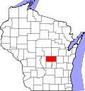
| County | Waushara |
| Elevation | 241 m (791 ft) |
| Time zone | UTC-6 (Central (CST)) |
| • Summer (DST) | UTC-5 (CDT) |
| Area code | 920 |
| GNIS feature ID | 1577528 [1] |
Brushville is an unincorporated community located in the Town of Bloomfield, Waushara County, Wisconsin, United States. [1] The community was founded around 1853 and was named for mill operators Herman and Eliphalet Brush. [2]