Poy Sippi (CDP), Wisconsin

Last updated

Poy Sippi
PoysippiWisconsinDowntownWIS49.jpg
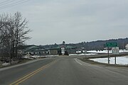
Looking north at downtown Poy Sippi
Poy Sippi (CDP), Wisconsin
Coordinates: 44°08′14″N88°59′43″W / 44.13722°N 88.99528°W / 44.13722; -88.99528
Country United States
State Wisconsin
County Waushara
Area
  Total
0.757 sq mi (1.96 km2)
  Land0.728 sq mi (1.89 km2)
  Water0.029 sq mi (0.08 km2)
Population
 (2010)
  Total
371
  Density490/sq mi (190/km2)
Time zone UTC-6 (Central (CST))
  Summer (DST) UTC-5 (CDT)
ZIP codes
54967
Area code 920

Poy Sippi is an unincorporated census-designated place in the town of Poy Sippi in Waushara County, Wisconsin, United States. [1] It is located at the intersection of Wisconsin Highway 49 and County H. [2] As of the 2010 census, its population is 371. [3]

Contents

History

The Pine River was called "Poygan Sippi" by Potawatomi Indians [4] because it flowed into Lake Poygan. The name was contracted to Poy Sippi. It is said to be a corruption of an Indian word meaning "Sioux river." [5] In the related Menominee language, it is called Pawāhnān-Sīpiah, "Wild Rice Gathering River", referring to the importance of wild rice as a staple crop to the local people. [6]

Images

References

  1. U.S. Geological Survey Geographic Names Information System: Poy Sippi (CDP), Wisconsin
  2. "Location of Poy Sippi". Mapquest . Retrieved April 20, 2010.
  3. "U.S. Census website". U.S. Census Bureau . Retrieved April 19, 2011.
  4. Poy Sippi Public Library website
  5. Fox, Edgar B.; Dudley, W. T. (1869). History and Directory of Green Lake and Waushara Counties, and the City of Ripon. p. 93.
  6. Hoffman, Mike. "Menominee Place Names in Wisconsin". The Menominee Clans Story. Retrieved October 6, 2018.