Richland Center, Wisconsin

Last updated

Richland Center
Richland Center August 2015.jpg
Richland Center's historic downtown, viewed from Court and Main Street
Richland County Wisconsin Incorporated and Unincorporated areas Richland Center Highlighted.svg
Location of Richland Center in Richland County, Wisconsin
USA Wisconsin location map.svg
Red pog.svg
Richland Center
Usa edcp location map.svg
Red pog.svg
Richland Center
Coordinates: 43°20′16″N90°23′5″W / 43.33778°N 90.38472°W / 43.33778; -90.38472
Country Flag of the United States.svg  United States
State Flag of Wisconsin.svg  Wisconsin
County Richland
Area
[1]
  Total4.77 sq mi (12.41 km2)
  Land4.69 sq mi (12.14 km2)
  Water0.08 sq mi (0.22 km2)
Elevation
[2]
728 ft (222 m)
Population
 (2020)
  Total5,114
  Density1,091/sq mi (421.3/km2)
Time zone UTC-6 (Central (CST))
  Summer (DST) UTC-5 (CDT)
ZIP Code
53581
Area code 608
FIPS code 55-67625 [3]
GNIS feature ID1578616 [2]
Website ci.richland-center.wi.us

Richland Center is a city in Richland County, Wisconsin, United States that also serves as the county seat. The population was 5,114 at the 2020 census. [4]

Contents

History

Richland Center was founded in 1851 by Ira S. Haseltine, a native of Andover, Vermont. Haseltine was drawn to the site because of its abundant water power, fertile prairies, and its proximity to the geographical center of Richland County. Haseltine offered to donate land to the county if Richland Center was voted the county seat. [5] In 1852 the Wisconsin Legislature formally declared Richland Center as the seat of justice for Richland County. [6] The present Richland County courthouse was built at Richland Center in 1889.

In 1876, a narrow gauge railroad branch connected Richland Center with the Chicago, Milwaukee & St. Paul Railroad at Lone Rock, Wisconsin, providing an outlet for the town's commerce. The line was originally constructed with maple rails, but it was rebuilt as a standard gauge iron railway in 1880. [7] On October 8, 1882, the town's railway depot was destroyed when an early morning fire ignited two kegs of gunpowder stored inside, causing an explosion that tore the roof from the building and scorched several nearby rail cars. [8] Another passenger depot, built in 1909, still stands today, serving as a visitor center for the community. [9]

Richland Center became an important location for the women's suffrage movement in Wisconsin after Laura Briggs James, Julia Bowen, and other residents founded the Richland Center Woman's Club in early 1882. The club quickly became the largest suffrage group in the state and was influential in organizing the movement throughout Wisconsin. [10] Susan B. Anthony visited Richland Center in 1886. Later, Laura James' daughter Ada James became influential in the movement, helping to found the Political Equality League in 1909 and advocating for women's rights, pacifism, birth control, and prohibition. [11] Locally, the women's club was the driving force behind the construction of the Richland Center City Auditorium, which served as the city hall from 1913 to 1998. [12] [13]

Frank Lloyd Wright was born in Richland Center in 1867. The A. D. German Warehouse, completed in 1921, is the only building designed by Wright in Richland Center and is an early representation of his Mayan Revival style.

Frank Lloyd Wright's A.D. German Warehouse, view from southeast A.D. German Warehouse view from SE.jpg
Frank Lloyd Wright's A.D. German Warehouse, view from southeast

The origin of GTE can be traced to the Richland Center Telephone Company. In 1918, three Wisconsin public utility accountants (Sigurd L. Odegard, John A. Pratt, and John F. O'Connell) purchased the Richland Center Telephone Company for $33,500. At that time, the modest company served only 1,466 telephones in southern Wisconsin. But in 1920, the three accountants formed the Commonwealth Telephone Company and engaged in an aggressive acquisition program, which dramatically expanded its services to more than 500,000 telephones in 25 states. Following bankruptcy during the Great Depression, the company reorganized into the General Telephone Corporation and continued to expand. After merging with Sylvania Electric Products in 1959, it once again changed its name, this time to General Telephone & Electronics Corporation (GT&E, later GTE). By 1969, GTE provided service to 10 million telephones across the nation, making it the largest independent telephone company in the United States.

Geography

Richland Center is located at 43°20′16″N90°23′5″W / 43.33778°N 90.38472°W / 43.33778; -90.38472 (43.337836, -90.384605). [14]

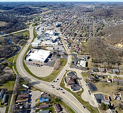
According to the United States Census Bureau, the city has a total area of 4.36 square miles (11.29 km2), of which 4.28 square miles (11.09 km2) is land and 0.08 square miles (0.21 km2) is water. [15]

The Pine River runs along the western edge of the town.

Demographics

Historical population
CensusPop.Note
1880 1,227
1890 1,81948.2%
1900 2,32127.6%
1910 2,65214.3%
1920 3,40928.5%
1930 3,6326.5%
1940 4,36420.2%
1950 4,6085.6%
1960 4,7463.0%
1970 5,0867.2%
1980 4,997−1.7%
1990 5,0180.4%
2000 5,1141.9%
2010 5,1841.4%
2020 5,114−1.4%
U.S. Decennial Census [16]

2020 census

As of the census of 2020, [17] the population was 5,114. The population density was 1,091.1 inhabitants per square mile (421.3/km2). There were 2,541 housing units at an average density of 542.1 per square mile (209.3/km2). The racial makeup of the city was 89.6% White, 1.3% Black or African American, 1.0% Asian, 0.3% Native American, 2.5% from other races, and 5.3% from two or more races. Ethnically, the population was 5.7% Hispanic or Latino of any race.

According to the American Community Survey estimates for 2016-2020, the median income for a household in the city was $41,724, and the median income for a family was $57,813. Male full-time workers had a median income of $42,995 versus $35,221 for female workers. The per capita income for the city was $24,829. About 12.0% of families and 16.5% of the population were below the poverty line, including 20.2% of those under age 18 and 13.7% of those age 65 or over. [18] Of the population age 25 and over, 90.2% were high school graduates or higher and 21.1% had a bachelor's degree or higher. [19]

2010 census

As of the census [20] of 2010, there were 5,184 people, 2,361 households, and 1,235 families residing in the city. The population density was 1,211.2 inhabitants per square mile (467.6/km2). There were 2,613 housing units at an average density of 610.5 per square mile (235.7/km2). The racial makeup of the city was 96.1% White, 0.7% African American, 0.2% Native American, 0.8% Asian, 1.2% from other races, and 0.9% from two or more races. Hispanic or Latino people of any race were 3.3% of the population.

There were 2,361 households, of which 25.5% had children under the age of 18 living with them, 37.4% were married couples living together, 10.8% had a female householder with no husband present, 4.1% had a male householder with no wife present, and 47.7% were non-families. 40.9% of all households were made up of individuals, and 21.1% had someone living alone who was 65 years of age or older. The average household size was 2.12 and the average family size was 2.87.

The median age in the city was 40 years. 22.1% of residents were under the age of 18; 10.1% were between the ages of 18 and 24; 23.2% were from 25 to 44; 24.3% were from 45 to 64; and 20.4% were 65 years of age or older. The gender makeup of the city was 46.4% male and 53.6% female.

2000 census

As of the census [3] of 2000, there were 5,114 people, 2,296 households, and 1,285 families residing in the city. The population density was 1,164.6 people per square mile (449.8/km2). There were 2,470 housing units at an average density of 562.5 per square mile (217.2/km2). The racial makeup of the city was 98.22% White, 0.16% African American, 0.25% Native American, 0.33% Asian, 0.35% from other races, and 0.68% from two or more races. Hispanic or Latino people of any race were 0.92% of the population.

There were 2,296 households, out of which 25.6% had children under the age of 18 living with them, 41.6% were married couples living together, 11.3% had a female householder with no husband present, and 44.0% were non-families. 38.2% of all households were made up of individuals, and 21.1% had someone living alone who was 65 years of age or older. The average household size was 2.15 and the average family size was 2.83.

In the city, the population was spread out, with 21.6% under the age of 18, 10.9% from 18 to 24, 24.2% from 25 to 44, 20.3% from 45 to 64, and 23.0% who were 65 years of age or older. The median age was 40 years. For every 100 females, there were 84.4 males. For every 100 females age 18 and over, there were 78.8 males.

Transportation

Richland Airport (93C) serves the city and surrounding communities.

Education

The city was home to the University of Wisconsin–Platteville Richland campus, which was a freshman-sophomore campus in the University of Wisconsin System. The college's last semester ended in May of 2023.

The city is served by the Richland School District.

Notable people

Sister cities

Richland Center has two sister cities: [21]

Related Research Articles

<span class="mw-page-title-main">Vernon County, Wisconsin</span> County in Wisconsin, United States

Vernon County is a county in the U.S. state of Wisconsin. As of the 2020 census, the population was 30,714. Its county seat is Viroqua.

<span class="mw-page-title-main">Richland County, Wisconsin</span> County in Wisconsin, United States

Richland County is a county in the U.S. state of Wisconsin. As of the 2020 census, the population was 17,304. Its county seat is Richland Center. The county was created from the Wisconsin Territory in 1842 and organized in 1850. It is named for the high quality of its soil.

<span class="mw-page-title-main">Iowa County, Wisconsin</span> County in Wisconsin, United States

Iowa County is a county in the U.S. state of Wisconsin. As of the 2020 census, the population was 23,709. Its county seat and largest city is Dodgeville. When created, it was part of the Michigan Territory. Iowa County is part of the Madison, Wisconsin, Metropolitan Statistical Area.

<span class="mw-page-title-main">Crawford County, Wisconsin</span> County in Wisconsin, United States

Crawford County is a county in the southwest part of the U.S. state of Wisconsin. As of the 2020 census, the population was 16,113. Its county seat is Prairie du Chien.

<span class="mw-page-title-main">Juneau, Wisconsin</span> City in Wisconsin, United States

Juneau is a city in Dodge County, Wisconsin, United States. The population was 2,658 at the 2020 census. It is the county seat of Dodge County.

<span class="mw-page-title-main">Lancaster, Wisconsin</span> City in Wisconsin, United States

Lancaster is a city in and the county seat of Grant County, Wisconsin, United States. The population was 3,907 at the 2020 census.

<span class="mw-page-title-main">Markesan, Wisconsin</span> City in Wisconsin, United States

Markesan is a city in Green Lake County, Wisconsin, United States. The population was 1,476 at the 2010 census. The center of population of Wisconsin is located in Markesan.

<span class="mw-page-title-main">Kewaunee, Wisconsin</span> City in Wisconsin, United States

Kewaunee is a city in Kewaunee County, Wisconsin, United States. The population was 2,837 at the 2020 census. Located on the northwestern shore of Lake Michigan, the city is the county seat of Kewaunee County. Its Menominee name is Kewāneh, an archaic name for a species of duck.

<span class="mw-page-title-main">Phillips, Wisconsin</span> City in Wisconsin, United States

Phillips is a city and the county seat of Price County, Wisconsin, United States. The population was 1,478 at the 2010 census.

<span class="mw-page-title-main">Buena Vista, Richland County, Wisconsin</span> Town in Wisconsin, United States

Buena Vista is a town in Richland County, Wisconsin, United States. The population was 1,807 at the 2020 census. The unincorporated communities of Gotham, and Sextonville are located within the town.

<span class="mw-page-title-main">Marshall, Richland County, Wisconsin</span> Town in Wisconsin, United States

Marshall is a town in Richland County, Wisconsin, United States. The population was 600 at the 2000 census. The unincorporated community of Gillingham is located in the town. The ghost town of McGrew was also located in the town.

<span class="mw-page-title-main">Sylvan, Wisconsin</span> Town in Wisconsin, United States

Sylvan is a town in Richland County, Wisconsin, United States. The population was 547 at the 2000 census. The unincorporated communities of Bosstown, Sabin, and Sylvan are located within the town. The ghost town of Mill Creek was also located in the town.

<span class="mw-page-title-main">Galesville, Wisconsin</span> City in Wisconsin, United States

Galesville is a city in Trempealeau County, Wisconsin, United States. The population was 1,662 at the 2020 census. A dam on Beaver Creek is located at Galesville, forming Lake Marinuka north of the city. The mayor is Vince Howe.

<span class="mw-page-title-main">Whitehall, Wisconsin</span> City in Wisconsin, United States

Whitehall is a city in Trempealeau County, Wisconsin, United States, along the Trempealeau River. The population was 1,645 at the 2020 census. It is the county seat of Trempealeau County.

<span class="mw-page-title-main">Westby, Wisconsin</span> City in Wisconsin, United States

Westby is a city in Vernon County, Wisconsin, United States. The population was 2,332 as of the 2020 census. The name "Westby" is a Norwegian name and literally translates to "Western city".

<span class="mw-page-title-main">Viola, Wisconsin</span> Village in Wisconsin, United States

Viola is a village in Richland (mostly) and Vernon counties in the U.S. state of Wisconsin. The population was 699 at the 2010 census. Of this, 477 were in Richland County, and 222 were in Vernon County.

<span class="mw-page-title-main">Washburn, Wisconsin</span> City in Wisconsin, United States

Washburn is a city and the county seat of Bayfield County, in the U.S. state of Wisconsin. The population was 2,051 at the 2020 census. The city is just east of and adjacent to the Town of Washburn. It is in northern Wisconsin, on the shore of Lake Superior's Chequamegon Bay.

<span class="mw-page-title-main">Merrill, Wisconsin</span> Place in Wisconsin, United States

Merrill is a city in and the county seat of Lincoln County, Wisconsin, United States. It is located to the south of and adjacent to the Town of Merrill. The population was 9,347, according to the 2020 census. Merrill is part of the United States Census Bureau's Merrill MSA, which includes all of Lincoln County. Together with the Wausau MSA, which includes all of Marathon County, it forms the Wausau-Merrill CSA.

<span class="mw-page-title-main">Black River Falls, Wisconsin</span> City in Wisconsin, United States

Black River Falls is a city in and the county seat of Jackson County, Wisconsin, United States. The population was 3,523 at the 2020 census. It is home to the administrative center of the Ho-Chunk Nation.

<span class="mw-page-title-main">Belle Center, Ohio</span> Village in Ohio, United States

Belle Center is a village in Logan County, Ohio, United States. The population was 809 at the 2020 census. It is a Tree City USA, one of the smallest in the state.

References

  1. "2019 U.S. Gazetteer Files". United States Census Bureau. Retrieved August 7, 2020.
  2. 1 2 "US Board on Geographic Names". United States Geological Survey. October 25, 2007. Retrieved January 31, 2008.
  3. 1 2 "U.S. Census website". United States Census Bureau . Retrieved January 31, 2008.
  4. "Census - Geography Profile: Richland Center city, Wisconsin". United States Census Bureau . Retrieved April 24, 2022.
  5. Butterfield, C. W. (1884). History of Crawford and Richland Counties, Wisconsin. Springfield, Illinois: Union Publishing Company. pp. 1150-1151.
  6. "An Act to Declare the County Seat of Richland County," Wisconsin Statutes 1852, c. 37.
  7. Butterfield (1884). pp. 948-950.
  8. Butterfield (1884). p. 1164
  9. "Richland Center Visitor Center." Richland Chamber & Development Alliance. Retrieved 2011-11-03.
  10. McBridge, Genevieve, G. (1993). On Wisconsin women: working for their rights from settlement to suffrage. Madison, Wisconsin: University of Wisconsin Press. pp. 101-102.
  11. "James, Ada Lois." Wisconsin Dictionary of History. Wisconsin Historical Society. Retrieved 2011-11-03.
  12. "National or State Registers Record: 182 N. Central Ave". Wisconsin Historical Society. January 1, 2012. Retrieved July 20, 2022.
  13. Hesselberg, George (August 2, 2013). "Donations launch effort for Richland Center auditorium". madison.com. Retrieved July 20, 2022.
  14. "US Gazetteer files: 2010, 2000, and 1990". United States Census Bureau. February 12, 2011. Retrieved April 23, 2011.
  15. "US Gazetteer files 2010". United States Census Bureau. Archived from the original on January 12, 2012. Retrieved November 18, 2012.
  16. "Census of Population and Housing". Census.gov. Retrieved June 4, 2015.
  17. "2020 Decennial Census: Richland Center city, Wisconsin". data.census.gov. U.S. Census Bureau. Retrieved July 20, 2022.
  18. "Selected Economic Characteristics, 2020 American Community Survey: Richland Center city, Wisconsin". data.census.gov. U.S. Census Bureau. Retrieved December 21, 2022.
  19. "Selected Social Characteristics, 2020 American Community Survey: Richland Center city, Wisconsin". data.census.gov. U.S. Census Bureau. Retrieved December 21, 2022.
  20. "U.S. Census website". United States Census Bureau . Retrieved November 18, 2012.
  21. "Richland Center Sister City Projects". Richland Center, Wisconsin. Retrieved September 6, 2020.