Gillingham, Wisconsin

Last updated
Gillingham, Wisconsin
GillinghamWisconsinSignWIS56.jpg
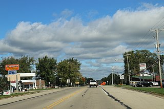
Sign for Gillingham on WIS 56
USA Wisconsin location map.svg
Red pog.svg
Gillingham, Wisconsin
Usa edcp location map.svg
Red pog.svg
Gillingham, Wisconsin
Coordinates: 43°25′35″N90°26′42″W / 43.42639°N 90.44500°W / 43.42639; -90.44500 Coordinates: 43°25′35″N90°26′42″W / 43.42639°N 90.44500°W / 43.42639; -90.44500
Country Flag of the United States.svg  United States
State Flag of Wisconsin.svg  Wisconsin
County Richland
Elevation
245 m (804 ft)
Time zone UTC-6 (Central (CST))
  Summer (DST) UTC-5 (CDT)
Area code(s) 608
GNIS feature ID1577610 [1]
Housing in Gillingham GillinghamWisconsinHousingWIS56.jpg
Housing in Gillingham

Gillingham ( /ˈɡɪlɪŋhæm/ , also /ˈɡɪlɪŋəm/ ) is an unincorporated community located in the town of Marshall, Richland County, Wisconsin, United States. Gillingham is located on Wisconsin Highway 56 7 miles (11 km) north-northwest of Richland Center. The post office was opened in 1880 with Hugh Morrow as the first postmaster. It was named for John Gillingham, who had encouraged Morrow to move to the area. [2]

Unincorporated area Region of land not governed by own local government

In law, an unincorporated area is a region of land that is not governed by a local municipal corporation; similarly an unincorporated community is a settlement that is not governed by its own local municipal corporation, but rather is administered as part of larger administrative divisions, such as a township, parish, borough, county, city, canton, state, province or country. Occasionally, municipalities dissolve or disincorporate, which may happen if they become fiscally insolvent, and services become the responsibility of a higher administration. Widespread unincorporated communities and areas are a distinguishing feature of the United States and Canada. In most other countries of the world, there are either no unincorporated areas at all, or these are very rare; typically remote, outlying, sparsely populated or uninhabited areas.

Marshall, Richland County, Wisconsin Town in Wisconsin, United States

Marshall is a town in Richland County, Wisconsin, United States. The population was 600 at the 2000 census. The unincorporated community of Gillingham is located in the town. The ghost town of McGrew was also located in the town.

Richland County, Wisconsin County in the United States

Richland County is a county in the U.S. state of Wisconsin. As of the 2010 census, the population was 18,021. Its county seat is Richland Center. The county was created from the Wisconsin Territory in 1842 and organized in 1850. It is named for the high quality of its soil. Some rural areas in the county have their power provided by the Richland Electric Cooperative.

Related Research Articles

Richlands, Virginia Town in Virginia, United States

Richlands is a town in Tazewell County, Virginia, United States. The population was 5,823 at the 2010 census. It is part of the Bluefield, WV-VA micropolitan area which has a population of 107,578.

Richland Center, Wisconsin City in Wisconsin, United States

Richland Center is a city in Richland County, Wisconsin, United States, which also serves as the county seat. The population was 5,184 at the 2010 census.

Bosstown, Wisconsin Unincorporated community in Wisconsin, United States

Bosstown is an unincorporated community located on U.S. Route 14 in the south-central part of the town of Sylvan in Richland County, Wisconsin, United States. The community was apparently named for shopkeeper and livestock dealer William H. Dosch who was popularly known as "Boss" Dosch.

University of Wisconsin–Platteville Richland

The University of Wisconsin–Platteville Richland is a two-year campus of the University of Wisconsin System located in Richland Center, Wisconsin, United States. The college is a satellite campus of the University of Wisconsin–Platteville.

Sandusky Township, Richland County, Ohio Township in Ohio, United States

Sandusky Township is one of the eighteen townships of Richland County, Ohio, United States. It is a part of the Mansfield Metropolitan Statistical Area. The 2000 census found 856 people in the township, 853 of whom lived in the unincorporated portions of the township.

Troy Township, Richland County, Ohio Township in Ohio, United States

Troy Township is one of the eighteen townships of Richland County, Ohio, United States. It is a part of the Mansfield Metropolitan Statistical Area. The 2000 census found 6,449 people in the township, 2,403 of whom lived in the unincorporated portions of the township.

Richland Township, Marion County, Ohio Township in Ohio, United States

Richland Township is one of the fifteen townships of Marion County, Ohio, United States. The 2010 census found 1,635 people in the township.

North Bloomfield Township, Morrow County, Ohio Township in Ohio, United States

North Bloomfield Township is one of the sixteen townships of Morrow County, Ohio, United States. The 2010 census found 1,863 people in the township.

Perry Township, Morrow County, Ohio Township in Ohio, United States

Perry Township is one of the sixteen townships of Morrow County, Ohio, United States. The 2010 census found 1,942 people in the township.

Gotham, Wisconsin Census-designated place in Wisconsin, United States

Gotham is an unincorporated census-designated place, in the town of Buena Vista, in Richland County, Wisconsin, United States. It is located at the intersection of Wisconsin Highway 60 and U.S. Route 14. It is just north of the Wisconsin River, northeast of Avoca and southeast of Richland Center. As of the 2010 census, its population was 191.

West Lima, Wisconsin Unincorporated community in Wisconsin, United States

West Lima is an unincorporated community in the Town of Bloom, Richland County, Wisconsin, United States. The community is located at the intersection of County Highway A and County Highway D.

Sextonville, Wisconsin Census-designated place in Wisconsin, United States

Sextonville is an unincorporated census-designated place located in the town of Buena Vista in Richland County, Wisconsin, United States. Sextonville is located on U.S. Route 14 southeast of Richland Center. Sextonville has a post office with ZIP code 53584. As of the 2010 census, its population is 551.

Excelsior, Richland County, Wisconsin Unincorporated community in Wisconsin, United States

Excelsior is an unincorporated community located in the town of Richwood, Richland County, Wisconsin, United States. Excelsior is located along County Highway F and Knapp Creek 5.5 miles (8.9 km) northwest of Blue River.

Tunnelville, Wisconsin Unincorporated community in Wisconsin, United States

Tunnelville is an unincorporated community in the counties of Richland and Vernon in the U.S. state of Wisconsin. The portion in Richland County is located in the town of Forest, and the portion in Vernon County is located in the town of Stark.

Basswood, Wisconsin Unincorporated community in Wisconsin, United States

Basswood is an unincorporated community located in the town of Eagle, Richland County, Wisconsin, United States. Basswood is located on County Highway E 7.5 miles (12.1 km) southwest of Richland Center.

Hub City, Wisconsin Unincorporated community in Wisconsin, United States

Hub City is an unincorporated community located in the town of Henrietta, Richland County, Wisconsin, United States. Hub City is located on Wisconsin Highway 80 9.5 miles (15.3 km) north of Richland Center.

Ash Ridge, Wisconsin Unincorporated community in Wisconsin, United States

Ash Ridge is an unincorporated community located in the towns of Bloom and Forest, Richland County, Wisconsin, United States. Ash Ridge is located on County Highway I 6.35 miles (10.22 km) east-southeast of Viola.

Ithaca (community), Wisconsin Unincorporated community in Wisconsin, United States

Ithaca is an unincorporated community located in the town of Ithaca, Richland County, Wisconsin, United States. Ithaca is located at the junction of Wisconsin Highway 58 and County Highway N 5.3 miles (8.5 km) east of Richland Center.

References

  1. U.S. Geological Survey Geographic Names Information System: Gillingham, Wisconsin
  2. Callary, Edward. Place Names of Wisconsin. Madison, WI: University of Wisconsin Press. p. 103. ISBN   978-0-299-30964-0.