
Prairies are ecosystems considered part of the temperate grasslands, savannas, and shrublands biome by ecologists, based on similar temperate climates, moderate rainfall, and a composition of grasses, herbs, and shrubs, rather than trees, as the dominant vegetation type. Temperate grassland regions include the Pampas of Argentina, Brazil and Uruguay, and the steppe of Ukraine, Russia and Kazakhstan. Lands typically referred to as "prairie" tend to be in North America. The term encompasses the area referred to as the Interior Lowlands of Canada, the United States, and Mexico, which includes all of the Great Plains as well as the wetter, hillier land to the east.

Pleasant Prairie is a village in Kenosha County, Wisconsin situated between Milwaukee and Chicago. The population was 19,719 at the 2010 census. The neighborhoods of Carol Beach, Dexter's Corner, Ranney, and Tobin are located within the village.

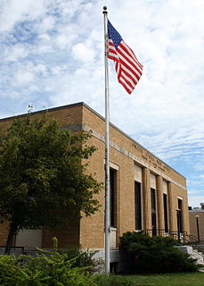
Sun Prairie is a city in Dane County in the U.S. state of Wisconsin. A suburb of Madison, it is part of the Madison Metropolitan Statistical Area. The city's population was 29,441 at the 2010 U.S. Census. It is the second most populous city in Dane County after Madison.
Prairie du Chien is a city in and the county seat of Crawford County, Wisconsin, United States. The population was 5,911 at the 2010 census. Its Zip Code is 53821.
Glacial Lake Wisconsin was a prehistoric proglacial lake that existed from approximately 18,000 to 14,000 years ago, at the end of the last ice age, in the central part of present-day Wisconsin in the United States.

The Wisconsin and Southern Railroad is a Class II regional railroad in southern Wisconsin and northeastern Illinois currently operated by Watco Companies. It operates former Chicago, Milwaukee, St. Paul and Pacific Railroad and Chicago and North Western Transportation Company (C&NW) trackage, mostly acquired by the state of Wisconsin in the 1980s.

The Driftless Area is a region in southeastern Minnesota, southwestern Wisconsin, northeastern Iowa, and the extreme northwestern corner of Illinois, of the American Midwest. The region escaped glaciation during the last ice age and, consequently, is characterized by steep, forested ridges, deeply-carved river valleys, and karst geology characterized by spring-fed waterfalls and cold-water trout streams. Ecologically, the flora and fauna of the Driftless Area are more closely related to those of the Great Lakes region and New England rather than those of the broader Midwest and central Plains regions. Colloquially, the term includes the incised Paleozoic Plateau of southeastern Minnesota and northeastern Iowa. The region includes elevations ranging from 603 to 1,719 feet at Blue Mound State Park and covers an area of 24,000 square miles (62,200 km2). The rugged terrain is due both to the lack of glacial deposits, or drift, and to the incision of the upper Mississippi River and its tributaries into bedrock.

The 608 area code currently covers much of southwestern Wisconsin, including the capital city of Madison as well as the cities of Waunakee, Mount Horeb, Verona, Sun Prairie, Monroe, Platteville, Lancaster, Portage, Baraboo, Wisconsin Dells, Beloit, Janesville, La Crosse, Prairie du Chien, Prairie du Sac, Sauk City, Viroqua and Sparta. It was created in 1955 as a split from area code 414, and was the third area code created in Wisconsin.
North American telephone area codes 715 and 534 are state of Wisconsin area codes covering most of the northern part of the state.

The University of Wisconsin–Madison Arboretum is a teaching and research facility of the University of Wisconsin–Madison and the site of historic research in ecological restoration. In addition to its 1,260 acres (5 km2) in Madison, Wisconsin, the Arboretum also manages 520 acres of remnant forests and prairies throughout Wisconsin.
Lake Wissota State Park is a 1,062-acre (430 ha) Wisconsin state park near the town of Chippewa Falls. The park is situated on the northeast shore of Lake Wissota, a reservoir on the Chippewa River. Camping, boating, and fishing are the most popular activities. Park lands are covered in a mix of pine/hardwood forests and prairie. Visitors can access the Old Abe State Trail and bike or hike 17.5 miles (28.2 km) to Brunet Island State Park.
The Drift Prairie is a geographic region of North Dakota and South Dakota. The gently rolling hills and shallow lakes were formed by glacial action, while the Badlands are characterized by the lack of this action, and the Red River Valley was a lake bed. This distinction causes the area considered as Drift Prairie to overlap somewhat with the Missouri Plateau, another of North Dakota's distinct geographic regions, but the Drift Prairie also includes the Souris River basin. Prairie grasses and wheat grow there making it a perfect place for ranchers. The prairie is filled with drift. Drift is soil consisting of clay, sand, and gravel.

Whitefish Dunes State Park is a 867-acre (351 ha) state park of Wisconsin, United States, on the eastern shore of the Door Peninsula. This day-use park preserves the most substantial sand dunes on the western shore of Lake Michigan. The remains of eight successive prehistoric Native American villages are on the National Register of Historic Places as Whitefish Dunes-Bay View Site.

Trempealeau National Wildlife Refuge is a 6,226-acre (25.20 km2) National Wildlife Refuge located along the Upper Mississippi River in extreme southern Buffalo County and extreme southwestern Trempealeau County in Wisconsin, United States.
The Long Tail Point Light, also known as the Tail Point Light, was a lighthouse in Green Bay, Wisconsin, USA. Long abandoned but still standing, it was succeeded by two further structures, both since destroyed.

Big Foot Prairie is an unincorporated community in both McHenry County, Illinois and Walworth County, Wisconsin, United States. The Illinois portion of the community, which is larger, is located in Chemung Township, while the Wisconsin portion is located in the Town of Walworth. Big Foot Prairie is located on U.S. Route 14, 5 miles (8.0 km) north of Harvard.
Spring Prairie is an unincorporated community located in the town of Spring Prairie, Walworth County, Wisconsin, United States. Spring Prairie is located at the intersection of Wisconsin Highway 11 and Wisconsin Highway 120 7.25 miles (11.67 km) east of Elkhorn.

Dunnville Barrens is a Wisconsin Department of Natural Resources-designated State Natural Area featuring a jack pine barrens plant community on a wide, sandy Chippewa River terrace. Open areas in the barrens contain scattered shrubs, such as beaked hazelnut, with a groundlayer composed of dry sand prairie species, including little bluestem, purple prairie clover, and fameflower. The eastern portion of the site contains an open area of swale topography, with areas of both wet and dry prairie. Plant composition in this area is diverse and includes species such as big bluestem, cream baptisia, Michigan lily, downy gentian, prairie alum-root, and Culver's root. Uncommon animal species include gorgone checkerspot, Leonard's skipper, and five-lined skink.
The Sand Prairie-Scrub Oak State Nature Preserve, formerly called the Mason County State Wildlife Refuge and Recreation Area, is a natural area located in the U.S. state of Illinois. Containing 1,460 acres, it is a dedicated state nature preserve. It is located in western Mason County. The nearest town is Kilbourne, Illinois and the nearest numbered highway is Illinois Route 97. It contains fragmentary examples of the ecosystem described in its name.


